 | Kranj-Stražišče (Šrotenturn) - Šmarjetna gora (east path)
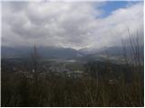
Šmarjetna gora is a panoramic peak rising above Kranj. From the summit, where the Church of St. Margaret and the Hotel Bellevue stand, a beautifu...
45 min |
| Kranj-Stražišče (Šrotenturn) - Šmarjetna gora (by cart track)
Šmarjetna gora is a panoramic peak rising above Kranj. From the summit, where the Church of St. Margaret and the Hotel Bellevue stand, a beautifu...
45 min |
 | Tičnica - Šmarjetna gora
Šmarjetna gora is a panoramic peak rising above Kranj. From the summit, where the Church of St. Margaret and the Hotel Bellevue stand, a beautifu...
50 min |
 | Strmica - Toško Čelo (via Brezarjevo brezno)
Toško Čelo is a 590-metre hill above the village of the same name. From the summit, or slightly below it, a beautiful view opens over part of Lju...
45 min |
 | Gradec - Osojnica
Osojnica is a forested hill located west of Pivka. The summit features a logbook box, stamp, and bench, but offers no views....
45 min |
 | Dobrič (Vedet) - Gora Oljka (by road)
Gora Oljka is a hill located east of Šmartno ob Paki. On the summit stands the Church of the Holy Cross, built in the mid-18th century. Just a fe...
50 min |
 | Pogorelec - Sedlata gorica (Pogorelec)
Sedlata gorica is a peak above the village of Podturn pri Dolenjskih Toplicah. It used to be forested, but today a clearing on the summit is used...
45 min |
 | Vilenica - Stari tabor (past Tupla jama)
Stari Tabor is a panoramic peak located west of Divača, north of Lokev, and south of the village of Povir. From the summit, which has a stamp and...
50 min |
 | Sežana - Zidovnik (Sedovnik) (by road)
Zidovnik is a 575-meter-high peak located west of Sežana. From the summit, which hosts a few transmitters, the view is limited by the forest and ...
1 h |
 | Poljana (Završnica) - Sveti Lovrenc above Zabreznica (via Mali vrh)
Sveti Lovrenc is a viewpoint with an eponymous chapel on the southern slope of the Brezniške peči ridge, 180 elevation meters above the village o...
1 h |
 | Rovte - Medvedje Brdo (via Trtovška grapa)
Medvedje Brdo is a small settlement located north of Hotedršica. The highest point of the village is a pleasant viewpoint on Šinkovcov grič (814 ...
1 h 10 min |
 | Kamnik - Visoka špica (via Stari grad)
An indistinct but clearly visible forested hill above Kamnik from everywhere. Due to the slightly lower Čokl, on which Kamnik Castle stands, it i...
50 min |
 | Kropa (Slovenska peč) - Sveti Primož in Felicijan (Jamnik)
The Church of St. Primož and Felicijan at Jamnik is located on a scenic grassy ridge rising between Kropa and Podblica. From the church or its ne...
1 h 10 min |
 | Zgornja Besnica (Nova vas) - Rovnik (east path)
Rovnik is a 707-meter-high peak located west of Zgornja Besnica. The summit features two benches, a wish bell, and a logbook box, but offers no v...
45 min |
 | Parje - Šilentabor
Šilentabor is a 751-meter-high peak just above the village of the same name. From the summit, near which there is a bench and a logbook box, ther...
1 h 15 min |
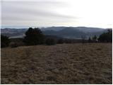 | Šembije - Vrh
Vrh is a 777-meter-high peak north of Šembije and southwest of Knežak. From the grassy summit, dotted with scattered bushes, fine views extend to...
45 min |
 | Činžat - Lobnikov vrh
Lobnikov vrh is a forested peak above the Dravska dolina valley, located between the settlements of Fala and Ruta. From the east, due to its remo...
1 h |
 | Kamnik - Castle Stari grad Kamnik (by road)
Stari grad Kamnik, formerly known as Zgornji grad (Oberstain), is located on a scenic hill east of Kamnik called Krniška gora. Today, only ruins ...
1 h |
 | Olševek - Apnišče (west path)
Apnišče is a 740 m high mountain between Možjanca and Štefanja gora. It is the highest point of the Šenčur municipality. The forested summit offe...
55 min |
 | Olševek - Apnišče (via Šterna)
Apnišče is a 740 m high mountain between Možjanca and Štefanja gora. It is the highest point of the Šenčur municipality. The forested summit offe...
55 min |
| Adergas - Apnišče (via Šterna)
Apnišče is a 740 m high mountain between Možjanca and Štefanja gora. It is the highest point of the Šenčur municipality. The forested summit offe...
1 h |
 | Radovljica - Lipnica Castle (Pusti grad above Lipnica) (via Ravnica)
Lipniški Castle, or Pusti grad above Lipnica (German: Waldenberg), is located on a panoramic hill above the Sava and Lipnica watercourses, more p...
1 h 5 min |
 | Železniki - Hujska (via Kres)
Hujska is a 706-meter-high peak located above Železniki, more precisely between the Dašnjica and Češnjica streams. At the summit there is a bench...
45 min |
 | Prevalje - Brinjeva gora (above Prevalje) (via Stations of the Cross)
Brinjeva gora is a popular excursion spot for Prevalje locals, located between the Meža River and Zelenbreški Stream. On the summit stands a smal...
1 h |
 | Mežica - Štalekarjev vrh (on ski slope)
Štalekarjev vrh is a hill above the former Mežica ski slope. There is no good view from the summit itself, but nice views open from the grassy ar...
45 min |
 | Sveta Barbara (Nova Hrastnica) - Sveti Andrej (above Zminec)
The Church of St. Andrew is located on a panoramic hill in the Sveti Andrej settlement. From the church, there is a fine view of the Škofjeloško ...
50 min |
 | Brzika - Joški vrh
Joški vrh is a 595-meter-high peak located on the northern side of Donačka gora. A short unmarked path leads to the summit, branching off from th...
1 h 15 min |
| Prelaz Vrhe - Joški vrh
Joški vrh is a 595-meter-high peak located on the northern side of Donačka gora. A short unmarked path leads to the summit, branching off from th...
1 h 5 min |
 | Stari Grad (Šega) - Dedni vrh (Šuštarica)
Dedni vrh, also known as Šuštarica, is a lesser-known peak in the Karawanks located north of Plešivec. The summit lies in the forest and offers l...
1 h |
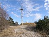
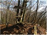
 | Slovenj Gradec - Rahtelov vrh (eastern path)
Rahtelov vrh is located north of Slovenj Gradec, above the left bank of the Mislinja River. On the summit there is a repeater facility and some t...
45 min |
| Slovenj Gradec - Rahtelov vrh (southeastern path)
Rahtelov vrh is located north of Slovenj Gradec, above the left bank of the Mislinja River. On the summit there is a repeater facility and some t...
45 min |
 | Škalnica - Pliševica (Way of the Cross)
Pliševica is a panoramic grassy summit above Škalnica, near the Slovenian border. From the top, marked by a concrete stone with a logbox, beautif...
50 min |