 | Ljubelj - Loibler Baba/Košutica (via koča na Ljubelju)
Košutica (also known as Ljubeljska Baba) is a panoramic mountain north of the western ridge of Košuta. From the summit, marked by a small cross a...
2 h 45 min |
 | Bučan - Loibler Baba/Košutica
Košutica (also known as Ljubeljska Baba) is a panoramic mountain north of the western ridge of Košuta. From the summit, marked by a small cross a...
2 h 45 min |
 | The Krma Valley - Mrežce
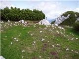
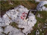
Mrežce is a panoramic peak near Lipanski vrh, which is visible on the other side of the gully between the two peaks. Since the slopes towards Pok...
2 h 55 min |
 | The Krma Valley - Lipanski vrh
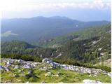
The panoramic Lipanski vrh is located above the Blejska koča on the Lipanca mountain pasture. From the summit, which drops steeply towards the Kr...
2 h 45 min |
 | Dom pod Storžičem - Storžič (via Škarjev rob)
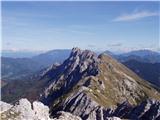
Storžič is a 2132 m high mountain located in the western part of the Kamnik-Savinja Alps. From the summit, where there is a cross, a beautiful vi...
3 h 5 min |
 | Jekarica - Storžič
Storžič is a 2132 m high mountain located in the western part of the Kamnik-Savinja Alps. From the summit, where there is a cross, a beautiful vi...
3 h |
 | Iličev rovt / Illitsch Rauth - Mittagskogel/Kepa (path 680)
Kepa (also Jepa, German: Mittagskogel) is a panoramic mountain in the western Karavanke, located on the border ridge between Slovenia and Austria...
3 h |
 | V Koncu - Kalška gora
Kalška gora lies between the Kalški greben and Kokrsko sedlo. From the grassy summit there is a beautiful view towards the nearby Kalški greben. ...
3 h 15 min |
 | The Krma Valley - Brda
Brda is a panoramic peak situated between Pokljuka and Krma. The summit has a stamp attached to a metal pole and offers a beautiful view towards ...
2 h 55 min |
 | Ravenska Kočna - Vratca (past the cableway)
The peak of Vratca stands west of Češka koča and is recognisable by its tower-like shape. There is little space on the very summit, but it offers...
2 h 15 min |
| Ravenska Kočna - Vratca (umik Žrela)
The peak of Vratca stands west of Češka koča and is recognisable by its tower-like shape. There is little space on the very summit, but it offers...
2 h 20 min |
| Ravenska Kočna - Vratca (via Štularjeva planina)
The peak of Vratca stands west of Češka koča and is recognisable by its tower-like shape. There is little space on the very summit, but it offers...
2 h 15 min |
| Makekova Kočna - Vratca
The peak of Vratca stands west of Češka koča and is recognisable by its tower-like shape. There is little space on the very summit, but it offers...
2 h 45 min |
 | Makekova Kočna - Veliki vrh
Veliki Vrh lies on the northwestern ridge of Kočna. The summit is unvegetated, offering a very fine view of neighbouring Kočna. Storžič and the K...
2 h 15 min |
 | Planina Jezerca - Vrh Korena (via Dom na Krvavcu)
Vrh Korena is located between Zvoh and Kalški greben near the Krvavec ski resort. The summit offers a beautiful view of the highest peaks in the ...
2 h 55 min |
 | Pod Krnico - Koschutnikturm (Košutnikov turn) (western way)
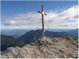
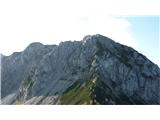
Košutnikov Turn is the highest peak in Košuta, the longest Slovenian ridge. The summit offers a beautiful view of the entire ridge. Austria and t...
2 h 15 min |
| Pod Krnico - Koschutnikturm (Košutnikov turn) (eastern way)
Košutnikov Turn is the highest peak in Košuta, the longest Slovenian ridge. The summit offers a beautiful view of the entire ridge. Austria and t...
2 h 30 min |
 | Planina Pungrat - Veliko Kladivo
Veliko Kladivo is a 2094 m high peak in the longest Slovenian ridge, Košuta. From the summit, which has a register box and stamp, there is a very...
2 h 15 min |
 | Bodenbauer - Ovčji vrh (Kozjak) / Geissberg (Kosiak) (direct way)
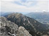
Ovčji Vrh or Kozjak, known in German as Geissberg or Kosiak, is a 2024 m high peak located north of the main Karawanks ridge. Rising above Celovš...
3 h |
| Ogris - Ovčji vrh (Kozjak) / Geissberg (Kosiak) (direct way)
Ovčji Vrh or Kozjak, known in German as Geissberg or Kosiak, is a 2024 m high peak located north of the main Karawanks ridge. Rising above Celovš...
3 h |
| Bodenbauer - Ovčji vrh (Kozjak) / Geissberg (Kosiak) (via Klagenfurter Hütte)
Ovčji Vrh or Kozjak, known in German as Geissberg or Kosiak, is a 2024 m high peak located north of the main Karawanks ridge. Rising above Celovš...
3 h 15 min |
| Ogris - Ovčji vrh (Kozjak) / Geissberg (Kosiak) (via Klagenfurter Hütte)
Ovčji Vrh or Kozjak, known in German as Geissberg or Kosiak, is a 2024 m high peak located north of the main Karawanks ridge. Rising above Celovš...
3 h 15 min |
 | Bodenbauer - Bielschitza/Svačica
Svačica is a less prominent peak in the main ridge of the Karawanks. It lies between Vrtača and Stol, slightly offset to the north. The summit, m...
3 h 15 min |
| Ogris - Bielschitza/Svačica
Svačica is a less prominent peak in the main ridge of the Karawanks. It lies between Vrtača and Stol, slightly offset to the north. The summit, m...
3 h 15 min |
 | Tolminske Ravne - Vogel (steep path)
Many associate the name Vogel first with the Vogel ski resort near the eponymous peak. From the north, it is recognizable by its pyramidal shape,...
3 h |
 | Podolševa (Rogar) - Govca (Olševa) (direct way)
Govca is the highest peak of the Olševa range, rising above Koprivna, Solčava, and Remšenik (Remšenik/Remschenig is a valley on the Austrian side...
2 h 10 min |
 | Podolševa (Sveti Duh, Strevc) - Govca (Olševa) (via Obel kamen)
Govca is the highest peak of the Olševa range, rising above Koprivna, Solčava, and Remšenik (Remšenik/Remschenig is a valley on the Austrian side...
2 h 30 min |
| Podolševa (Sveti Duh, Strevc) - Govca (Olševa)
Govca is the highest peak of the Olševa range, rising above Koprivna, Solčava, and Remšenik (Remšenik/Remschenig is a valley on the Austrian side...
2 h 15 min |
| Podolševa (Rogar) - Govca (Olševa) (via Obel kamen)
Govca is the highest peak of the Olševa range, rising above Koprivna, Solčava, and Remšenik (Remšenik/Remschenig is a valley on the Austrian side...
2 h 25 min |
 | Jochalm - Reißkofel (235-1)
Reißkofel is a 2371 m high mountain in the Gailtal Alps. The summit, marked by a cross, also features a summit register. The view is particularly...
3 h |
 | Jochalm - Reißkofel (path 235)
Reißkofel is a 2371 m high mountain in the Gailtal Alps. The summit, marked by a cross, also features a summit register. The view is particularly...
3 h 25 min |
 | Belopeška jezera - Mala Ponca / Ponza Piccola
Mala Ponca is a 1,925 m high peak between Planica and the Belopeška lakes. Though lower than neighboring Visoka Ponca, it offers fine viewsespeci...
2 h 45 min |
 | Spodnje Belopeško jezero - Mala Ponca / Ponza Piccola (on ridge)
Mala Ponca is a 1,925 m high peak between Planica and the Belopeška lakes. Though lower than neighboring Visoka Ponca, it offers fine viewsespeci...
3 h |
 | Plockenpass - Monte Floriz
Monte Floriz is a 2,184 m high grassy peak located south of the Marinelli hut. From the summit there is a very nice view of the Coglians group; i...
3 h |
 | The Krma Valley - Okroglež
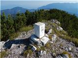
Okroglež is a peak covered with dwarf pines, located between Debela peč and Brda. From the summit, which has a stamp (no logbook), a nice view op...
3 h 10 min |
 | Sella Nevea - Monte Bila pec
Bela peč (Italian: Monte Bila pec) is a 2,146-meter-high mountain located north of the main Kanin ridge. From the summit, which has a logbook box...
2 h 45 min |
 | Ljubelj - Lokovnikov Grintovec / Grintoutz (via Koča na Ljubelju)
Lokovnikov Grintovec is a dwarf pine-covered peak north of Košutica, separated from it by Dovjakovo sedlo saddle (1,728 m). Its southwestern and ...
2 h 45 min |
 | Bučan - Lokovnikov Grintovec / Grintoutz
Lokovnikov Grintovec is a dwarf pine-covered peak north of Košutica, separated from it by Dovjakovo sedlo saddle (1,728 m). Its southwestern and ...
2 h 45 min |
 | Coot Parking Lot - Velika Baba (Kanin) (over Zg. Brda and saddle Med Baban)
Velika Baba is the southernmost two-thousander of the Kanin mountains. It is separated from the main ridge to the north by the saddle Med Baban, ...
3 h 15 min |
 | Podolševa (Sveti Duh, Strevc) - Obel kamen (Olševa) (west path)
Obel kamen is a 1,911-meter-high peak located in the ridge of Olševa. On the summit is a border stone marked RS XXII 1; a cross and summit logboo...
2 h |
| Podolševa (Rogar) - Obel kamen (Olševa) (west path)
Obel kamen is a 1,911-meter-high peak located in the ridge of Olševa. On the summit is a border stone marked RS XXII 1; a cross and summit logboo...
1 h 55 min |
 | Podolševa (Sveti Duh, Strevc) - Obel kamen (Olševa) (east path)
Obel kamen is a 1,911-meter-high peak located in the ridge of Olševa. On the summit is a border stone marked RS XXII 1; a cross and summit logboo...
2 h 15 min |
| Podolševa (Rogar) - Obel kamen (Olševa) (east path)
Obel kamen is a 1,911-meter-high peak located in the ridge of Olševa. On the summit is a border stone marked RS XXII 1; a cross and summit logboo...
2 h 10 min |