 | Ocinje - Sveta Ana pri Igu / Sankt Anna am Aigen
Sveta Ana pri Igu / Sankt Anna am Aigen is a settlement near the border with Slovenia where a church of St. Anne more than 300 years old stands. ...
40 min |
 | Ženavlje (memorial plaque) - Križarka
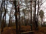
Križarka, also known as Klamnik, is the third highest peak in Prekmurje at 413 meters. The summit is located in a forest and does not offer a par...
1 h 5 min |
 | border crossing Sotina - Serdiški breg (Rdeči breg) (Austrian path)
Serdiški breg (Rdeči breg) is a 416 m high hill located right next to the Austrian border. From its grassy summit, which has a few benches and a ...
45 min |
 | border crossing Kramarovci - Serdiški breg (Rdeči breg)
Serdiški breg (Rdeči breg) is a 416 m high hill located right next to the Austrian border. From its grassy summit, which has a few benches and a ...
1 h |
 | Komare doline - Krog
Krog is a 418-meter-high hill located between Vrh križa and Kuk. From the summit, which is lightly wooded mainly with pines, there is a view of V...
50 min |
 | Zagorica pri Dobrniču - Sveti Križ (Liška gora)
The Church of the Holy Cross is located east of the slightly higher, forested Lisec. From the church, near which there is a large meadow, there i...
40 min |
 | Ljubljana (Botanični vrt) - Črni hrib (Golovec)
Črni hrib is a 440 m high hill in the central part of Golovec. The summit, which has a NOB monument and a bench with a table, is crossed by the T...
55 min |
| Ljubljana (Rakovnik) - Črni hrib (Golovec)
Črni hrib is a 440 m high hill in the central part of Golovec. The summit, which has a NOB monument and a bench with a table, is crossed by the T...
50 min |
 | Ljubljana (Gruberjeva brv) - Črni hrib (Golovec)
Črni hrib is a 440 m high hill in the central part of Golovec. The summit, which has a NOB monument and a bench with a table, is crossed by the T...
50 min |
| Ljubljana (Štepanja vas) - Črni hrib (Golovec)
Črni hrib is a 440 m high hill in the central part of Golovec. The summit, which has a NOB monument and a bench with a table, is crossed by the T...
50 min |
 | Podgrad - Castle Stari grad (Stari Osterberg) (via millstone quarry)
Stari grad, or Stari Osterberg, was first mentioned in the 12th century (less likely as early as 1015), at which time the castle belonged to the ...
45 min |
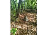
 | Podgrad - Murjevka
Murjevka is a 443-meter-high peak above the valley of the Besnica stream, south of Podgrad. The summit is located in the forest so it doesn't off...
40 min |
 | Ljubljana (Botanični vrt) - Mazovnik (Golovec)
Mazovnik, at 450 m, is the highest peak of Golovec, a hill range located on the southeastern outskirts of Ljubljana. Golovec remained bare until ...
1 h 5 min |
 | Ljubljana (London) - Mazovnik (Golovec)
Mazovnik, at 450 m, is the highest peak of Golovec, a hill range located on the southeastern outskirts of Ljubljana. Golovec remained bare until ...
35 min |
| Ljubljana (Rakovnik) - Mazovnik (Golovec)
Mazovnik, at 450 m, is the highest peak of Golovec, a hill range located on the southeastern outskirts of Ljubljana. Golovec remained bare until ...
55 min |
 | Ljubljana (Štepanja vas) - Mazovnik (Golovec)
Mazovnik, at 450 m, is the highest peak of Golovec, a hill range located on the southeastern outskirts of Ljubljana. Golovec remained bare until ...
1 h |
 | Podgrad - Lazarjev vrh
Lazarjev vrh is a 452-meter-high peak above the confluence of the Sava, Ljubljanica, and Kamniška Bistrica rivers, east of the Podgrad settlement...
50 min |
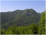 | Volče - Mengore
Mengore (453 m) rises between Most na Soči, Volče, and Tolmin. From the summit, where the Church of St. Mary stands alongside the St. Joseph's sh...
40 min |
 | Suhadole - Koseški hrib (by cart track)
Koseški hrib is located between Kuharjev boršt and Koseze, the settlement after which the peak is also named. From the summit, which has a table,...
40 min |
 | Sveti Lovrenc nad Dragomerom - Strmca (via Vrhovčev grič)
Strmca is a lesser-known forested hill located between the settlements of Brezje pri Dobrovi and Log pri Brezovici. Due to the forest cover, ther...
50 min |
 | Zlogonje - Vidikovac Vukovoj
Vidikovac Vukovoj is located on the eastern part of Ravna Gora. Built in 2025, it quickly became extremely popular among visitors and hikers from...
45 min |
 | Brezje pri Dobrovi - Vrhovčev grič (via Strmca)
Vrhovčev grič is an indistinct, forested peak located just a few meters off the marked trail between Debeli hrib and Strmca....
45 min |
 | Ruše - Kluže
Kluže (also Kluža) is a 496-meter-high hill situated between the right bank of the Drava and the left bank of the Lobnica. A short unmarked path ...
45 min |
 | Lake Gradišče - Sveti Mohor on Mohorjev hrib (via Prikrnica)
The church of St. Mohor is situated on a panoramic rise, the lower peak of Mohorjev hrib above Moravče. From the top, a beautiful view opens up t...
1 h 5 min |
 | Lake Gradišče - Sveti Mohor on Mohorjev hrib
The church of St. Mohor is situated on a panoramic rise, the lower peak of Mohorjev hrib above Moravče. From the top, a beautiful view opens up t...
50 min |
 | Sveti Mihovil (nad Komižo) - Mali Hum
Mali Hum is located on the island of Vis above the town of Komiža. A cairn marks the summit. Fine views extend to Hum, Komiža, and the nearby isl...
50 min |
 | Hraše - Smledniški hrib (Stari grad)
Stari grad (also known as Smlednik Castle) is located on a small hill southwest of Valburga. In recent years, the castle has been renovated and n...
45 min |
 | Donja Višnjica - Kukelj (direct steep path)
Kukelj is an indistinct summit between the villages of Donja Višnjica, Zlogonje, and Goranec. Rising to 521 meters, it is the highest peak in the...
45 min |
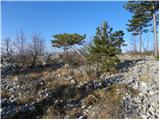
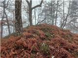 | Liboje - Kamčič (via organic farm Kralj - northern approach)
Kamčič is a wooded peak in the Posavje Hills, located north of Šmohor between Kotečnik to the left and Veliki Slomnik to the right. It is recogni...
45 min |
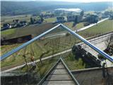
 | Buzet Railway Station - Kuk (above Buzet)
Kuk is a grassy peak above Buzet. It is located on the edge of the cliff above Buzet Railway Station. From the summit, a beautiful view opens up ...
35 min |
 | Dragomer - Vrh (Debeli hrib)
Vrh is a 540-meter-high hill on the Debeli hrib ridge, which lies between the Ljubljana Marshes and the Horjulščica river valley. The view from t...
40 min |
 | Church of St. Lovrenc above Dragomer - Vrh (Debeli hrib) (via Vrhovčev grič)
Vrh is a 540-meter-high hill on the Debeli hrib ridge, which lies between the Ljubljana Marshes and the Horjulščica river valley. The view from t...
45 min |
 | Vrzdenec - Gradišče above Žažar (via Žažar)
Gradišče above Žažar is a panoramic peak topped by a large wooden cross. From the summit, which also has a summit logbook with a stamp, there is ...
1 h |
| Vrzdenec - Gradišče above Žažar (via Plesa)
Gradišče above Žažar is a panoramic peak topped by a large wooden cross. From the summit, which also has a summit logbook with a stamp, there is ...
45 min |
 | Želimlje - Castle Stari grad above Želimlje
Stari grad above Želimlje is a forest-covered peak located between Želimlje and Rogatec above Želimlje....
50 min |
 | Bad Gleichenberg (Eichgraben Weg) - Bschaidkogel (via Mühlsteinbruch)
Bschaidkogel is a 563-meter-high mountain located northeast of the town of Bad Gleichenberg....
50 min |
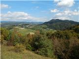
 | Povodje - Veliki vrh (Rašica)
Veliki vrh is a 568-meter-high hill located west of Vrh Staneta Kosca. Just a few meters below the otherwise forested summit lies a small abyss n...
45 min |