 | Jevnica - Janče
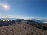
Janče is a 792-meter-high peak situated between the Sava River and the Besnica stream valley. From the summit, where a mountain hut stands and th...
1 h 45 min |
 | Breg (Liški potok) - Lisca
Lisca is a panoramic peak located north of Sevnica. From the summit, where a meteorological radar station stands, there are fine views of Posavsk...
2 h 5 min |
| Railway station Sevnica - Lisca (From Sevnica over Zajčja Gora to Lisca)
Lisca is a panoramic peak located north of Sevnica. From the summit, where a meteorological radar station stands, there are fine views of Posavsk...
2 h 50 min |
| Krakovo (Mastnak wine cellar) - Lisca (via Skalce)
Lisca is a panoramic peak located north of Sevnica. From the summit, where a meteorological radar station stands, there are fine views of Posavsk...
1 h 50 min |
| Krakovo (Mastnak wine cellar) - Lisca (Pastirčkova pot)
Lisca is a panoramic peak located north of Sevnica. From the summit, where a meteorological radar station stands, there are fine views of Posavsk...
1 h 55 min |
| Sevnica - Lisca (via Zajčja Gora and Skalce)
Lisca is a panoramic peak located north of Sevnica. From the summit, where a meteorological radar station stands, there are fine views of Posavsk...
2 h 55 min |
| Krakovo (Mastnak wine cellar) - Lisca (past Sveti Jošt)
Lisca is a panoramic peak located north of Sevnica. From the summit, where a meteorological radar station stands, there are fine views of Posavsk...
1 h 55 min |
 | Breg - Sveti Lovrenc (above Okroglice)
The Church of St. Lovrenc is located east of Zidani Most and northwest of Sevnica, above the village of Okroglice and near the Lovrenc peak. From...
1 h 45 min |
 | Rimske Toplice - Dom v Gorah (via Ogeški potok)
The Dom v Gorah mountain hut is located east of Hrastnik, just a few meters below the 786 m high peak where the church of St. Jurij stands. From ...
2 h 40 min |
| Rimske Toplice (Šmarjeta) - Dom v Gorah (via Lurd)
The Dom v Gorah mountain hut is located east of Hrastnik, just a few meters below the 786 m high peak where the church of St. Jurij stands. From ...
2 h 40 min |
 | Source of Hubelj - Navrše
Navrše is a little-known peak southeast of Otliško okno. It offers nice views of the Vipava Valley and the peaks surrounding it....
1 h 35 min |
 | Zidani Most - Veliko Kozje (mimo Gašperjeve koče)
Veliko Kozje is a mountain that rises steeply above the left bank of the Savinja River, descending more gently towards the Sava River. The highes...
2 h 40 min |
 | Gračnica - Veliko Kozje
Veliko Kozje is a mountain that rises steeply above the left bank of the Savinja River, descending more gently towards the Sava River. The highes...
2 h 15 min |
 | Laško - Dom na Šmohorju
The mountain lodge on Šmohor is located on a picturesque and scenic ridge between Laško, Liboje and Zabukovica. The lodge, a popular spot for bot...
2 h |
 | Tremerje - Dom na Šmohorju
The mountain lodge on Šmohor is located on a picturesque and scenic ridge between Laško, Liboje and Zabukovica. The lodge, a popular spot for bot...
2 h 15 min |
 | Laško - Malič
Malič is a 936-meter-high peak situated between Celje and Laško, more precisely above Spodnja Rečica. From the summit, which has a transmitter, b...
2 h 15 min |
 | Tremerje - Malič (on western ridge of Malič)
Malič is a 936-meter-high peak situated between Celje and Laško, more precisely above Spodnja Rečica. From the summit, which has a transmitter, b...
2 h |
 | Gradišče pri Vipavi - Gradiška Tura (via Plaz)
Gradiška Tura is a prominent 754-meter peak rising at the far western edge of the Nanos plateau directly above the Vipava Valley. Thanks to its e...
2 h |
 | Zamedveje - Korada
Korada is a panoramic peak west of the Soča River and on the northern edge of Goriška Brda. From the summit, which has a summit logbox, there is ...
2 h 30 min |
 | Podgozd - Sveti Peter
Sveti Peter is a partly forested peak in Suha Krajina above the village of Dvor. On the summit stands a small shelter (usually open on Sundays) a...
1 h 50 min |
 | Podsreda - Veliki Špiček (through Osredek pri Podsredi)
Veliki Špiček is the highest peak of Brežice municipality. From the top a nice view spreads towards the south and east. Most of Brežice municipal...
2 h 45 min |
 | Radeče - Nebeška gora
Nebeška gora is the highest peak of the Radeče ob Savi municipality. At the summit there is a logbook, stamp, luck bell, and some benchesall plac...
2 h 45 min |
| Zidani Most - Nebeška gora (eastern path)
Nebeška gora is the highest peak of the Radeče ob Savi municipality. At the summit there is a logbook, stamp, luck bell, and some benchesall plac...
2 h 40 min |
| Zidani Most - Nebeška gora (western path)
Nebeška gora is the highest peak of the Radeče ob Savi municipality. At the summit there is a logbook, stamp, luck bell, and some benchesall plac...
2 h 45 min |
 | Laško (cemetery Laško) - Govško brdo
Govško brdo is an 811-meter-high hill located west of the village of Huda Jama above Laško. From the summit, which features a logbook box and sta...
2 h 35 min |
 | Studenice - Plešivec (at Boč)
Peace, silence, varied terrain... these are characteristics of the peak at the crossroads of numerous paths between the Maribor, Celje, and Ptuj ...
2 h |
 | Studenice - Plešivec (at Boč) (final part on forest road)
Peace, silence, varied terrain... these are characteristics of the peak at the crossroads of numerous paths between the Maribor, Celje, and Ptuj ...
2 h |
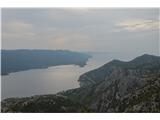 | Bilopolje - Sveti Ilija (Pelješac)
Sveti Ilija, also Zmijino brdo, is a 961-meter-high mountain and the highest peak of the Pelješac Peninsula. From the top, a nice view opens up o...
2 h 20 min |
 | Nakovana - Sveti Ilija (Pelješac)
Sveti Ilija, also Zmijino brdo, is a 961-meter-high mountain and the highest peak of the Pelješac Peninsula. From the top, a nice view opens up o...
2 h 45 min |
 | Zvekovica - Stražišće (by road)
Stražišće is a peak rising above Cavtat, offering a magnificent view of Cavtat, Konavle and Dubrovnik.A cross stands on the summit in memory of t...
2 h |
 | Railway station (Most na Soči) - Viewpoint Široko
The viewpoint lies at 755 m above Most na Soči in the namesake hamlet of Tolminski Lom. Access is possible by car to the nearby tourist farm or o...
1 h 40 min |
 | Rimske Toplice - Vrhe (at Gore) (via Ogeški potok)
Vrhe is a forested 781-meter-high peak located northwest of the Planinski dom hut in Gore....
2 h 50 min |
| Rimske Toplice (Šmarjeta) - Vrhe (at Gore) (via Lurd)
Vrhe is a forested 781-meter-high peak located northwest of the Planinski dom hut in Gore....
2 h 50 min |
 | Slake (Church of the Virgin Mary on Pesek) - Plešivec (Rudnica)
Plešivec is a forest-covered peak on Rudnica, its highest point. The summit has a summit register box, a bench, and a table....
2 h |
| Podčetrtek (Terme Olimia) - Plešivec (Rudnica) (past castle Podčetrtek)
Plešivec is a forest-covered peak on Rudnica, its highest point. The summit has a summit register box, a bench, and a table....
2 h 5 min |
 | Mošćenice - Kremenjak (past Kalvarija)
Kremenjak is a scenic rocky peak on Učka. The peak is a point on the Istrian Mountain Path. From the peak, which has a summit book box and a bord...
2 h 45 min |
| Mošćenice - Kremenjak (on marked path)
Kremenjak is a scenic rocky peak on Učka. The peak is a point on the Istrian Mountain Path. From the peak, which has a summit book box and a bord...
2 h 40 min |
 | Mošćenice - Planinsko zavetišče Kremenjak (past Kalvarija)
The Kremenjak Mountain Shelter is located on a small peak between Kremenjak and Brgud. The bivouac is of quite unusual shape and has some benches...
2 h 45 min |
| Mošćenice - Planinsko zavetišče Kremenjak (on marked path)
The Kremenjak Mountain Shelter is located on a small peak between Kremenjak and Brgud. The bivouac is of quite unusual shape and has some benches...
2 h 40 min |
 | Pišece (Pri mlinu) - Veliki vrh (Orlica)
Veliki vrh is the highest point of the Orlica hills at 701 meters above sea level, stretching along the border between Posavje and Kozjansko and ...
2 h 40 min |