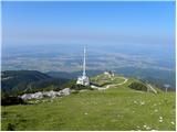
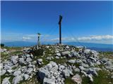
 | Dom na Gospincu - Veliki Zvoh
Veliki Zvoh is the highest point of the Krvavec ski resort. The cable car does not quite reach the summit but stops only a few metres short. A fe...
1 h 25 min |
| Kriška planina - Veliki Zvoh
Veliki Zvoh is the highest point of the Krvavec ski resort. The cable car does not quite reach the summit but stops only a few metres short. A fe...
1 h 25 min |
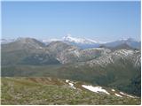
 | Snežniška Grda jama - Veliki Snežnik (via Mali Snežnik)
Veliki Snežnik, at 1796 meters, is the highest peak in the nearby and distant surroundings, offering beautiful views over much of Slovenia and ne...
1 h 25 min |
 | Gašperjev hrib - Veliki Snežnik
Veliki Snežnik, at 1796 meters, is the highest peak in the nearby and distant surroundings, offering beautiful views over much of Slovenia and ne...
1 h 30 min |
 | Gašperjev hrib - Veliki Snežnik
Veliki Snežnik, at 1796 meters, is the highest peak in the nearby and distant surroundings, offering beautiful views over much of Slovenia and ne...
1 h 30 min |
 | end of road on Vogar - Pršivec (direct way)
Pršivec is a panoramic mountain above Lake Bohinj. The view is extensive in all directions: Triglav and the surrounding mountains are clearly vis...
1 h 30 min |
 | Planina Dol - Konj
Konj is an 1803 m high peak located between Velika Planina and Presedljaj. From the summit there is a beautiful view of the highest peaks of the ...
1 h 30 min |
 | Ski hotel Vogel - Šija
Šija is located above the Vogel ski resort in the Lower Bohinj Mountains. From the summit, there is a nice view of the neighboring peaks in the s...
1 h 30 min |
 | Tonkina koča na Vršiču - Sovna glava (on old road)
Sovna Glava is a 1750-meter-high grassy peak situated between Prisank and the Vršič Pass. From the summit, there is a nice view of the peaks risi...
1 h 10 min |
 | Dom na Smrekovcu - Komen (Direct way)
At 1684 meters, Komen is the highest peak in the Smrekovec mountain range, which borders between Styria and Carinthia. In good weather, the summi...
2 h |
 | Planina Vodol - Veliki Travnik (Turnovka)
Veliki Travnik, also known as Turnovka by the locals, is located on the western edge of the Smrekovec mountain range. From the summit, which has ...
2 h |
 | Sviščaki - Mali Snežnik
Mali Snežnik is a peak on the western ridge of Snežnik. Covered with dwarf pines, the summit offers beautiful views of the neighboring Veliki Sne...
1 h 50 min |
 | Walischeben - Hofalmkogel (Packalpe) (past the cross)
Hofalmkogel is a less distinct peak in the ridge from Großenberg to Speikkogel. The summit is broad and mostly grassy. From the top, there is a b...
2 h 5 min |
 | Walischeben - Speikkogel (Packalpe)
Speikkogel is a spacious and grassy summit in the Packalpe mountain group. From the top, there is a beautiful view towards the Slovenian mountain...
2 h |
 | Salzstiegelhaus - Speikkogel (Packalpe)
Speikkogel is a spacious and grassy summit in the Packalpe mountain group. From the top, there is a beautiful view towards the Slovenian mountain...
1 h 15 min |
 | Panoramarestaurant Oben - Petzen (Kordeschkopf) (Peca (Kordeževa glava))
Kordeževa glava, better known as Peca, is the highest peak of the Peca range. It is located on the border with Austria above the Mežiška dolina v...
2 h 5 min |
 | Panoramarestaurant Oben - Petzen (Kordeschkopf) (Peca (Kordeževa glava)) (past old cotage)
Kordeževa glava, better known as Peca, is the highest peak of the Peca range. It is located on the border with Austria above the Mežiška dolina v...
2 h 5 min |
 | Rifugio Pelizzo - Monte Mataiur/Matajur (via Fonte Skrila)
Matajur is a panoramic mountain located on the border between Slovenia and Italy. From the summit there is a beautiful view of Kobariški or Bregi...
1 h 15 min |
 | Rosstratte - Dobratsch / Dobrač (by road)
Dobrač, or in German Dobratsch and also known as Villacher Alpen, is a 2166-meter-high mountain situated on the far eastern edge of the Gailtal A...
1 h 20 min |
 | Rosstratte - Dobratsch / Dobrač (by road)
Dobrač, or in German Dobratsch and also known as Villacher Alpen, is a 2166-meter-high mountain situated on the far eastern edge of the Gailtal A...
2 h |
 | Turracher Höhe - Kornock (northern way)
Kornock is a panoramic peak located west of the Turracherhöhe mountain pass. The summit, which is also the highest point of the Turracherhöhe ski...
1 h 15 min |
 | Turracher Höhe - Schoberriegel
Schoberriegel is a 2,208 m high peak located between the Turracher Höhe alpine pass and the slightly higher Gruft. From the summit, where a cross...
1 h 20 min |
 | Turracher Höhe - Gruft
Gruft is a grass-covered peak located southeast of the Turracher Höhe pass in the heart of the Gurktal Alps. From its 2,232 m high summit there a...
1 h 45 min |
 | Sporthotel Maltatal - Arlhöhe
Arlhöhe is an inconspicuous peak located north of the Kölnbreinspeicher reservoir (above the Maltatal valley). The summit features a panorama boa...
1 h 45 min |
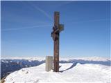
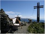
 | Planina Jezerca - Krvavec
Krvavec is a 1,853-meter-high peak located in the heart of the eponymous ski resort. From the summit, which is crisscrossed with cable cars, ther...
1 h 10 min |
 | Planina Loka - Lanež (eastern way)
Lanež is a less distinct peak on the eastern part of Raduha. From the spacious summit a nice view opens on nearby Mala Raduha, Olševa, Peca, Uršl...
1 h 25 min |
| Planina Loka - Lanež (via Durce)
Lanež is a less distinct peak on the eastern part of Raduha. From the spacious summit a nice view opens on nearby Mala Raduha, Olševa, Peca, Uršl...
1 h 25 min |
 | Panoramarestaurant Oben - Feistritzer Spitze
Bistriška špica is a 2113 m high peak located on the Austrian side of Peca. From the summit, which features a cross, there is a fine view of the ...
2 h 5 min |
 | Panoramarestaurant Oben - Feistritzer Spitze (past old cotage)
Bistriška špica is a 2113 m high peak located on the Austrian side of Peca. From the summit, which features a cross, there is a fine view of the ...
2 h |
 | Panoramarestaurant Oben - Končnikov vrh (Peca)
Končnikov vrh (German: Knieps) is a 2109 m high peak situated in the central part of Peca. From the grassy summit, there is a beautiful view of t...
1 h 20 min |
 | Panoramarestaurant Oben - Končnikov vrh (Peca) (past old cotage)
Končnikov vrh (German: Knieps) is a 2109 m high peak situated in the central part of Peca. From the grassy summit, there is a beautiful view of t...
1 h 15 min |
 | Torka - Gladki vrh (Ratitovec)
Gladki vrh (Ratitovec), at 1,667 meters, is the most visited peak in the Ratitovec range. From its bare summit, which features a panorama board, ...
1 h 20 min |
 | Pod Peco/Koprein-Petzen - Topitza
Topica, or Topitza in German, is a 1649-meter-high peak situated northeast of Železna Kapla. From the summit, where a cross stands, a nice view o...
1 h 15 min |
| Koprivna (Kumer) - Topitza
Topica, or Topitza in German, is a 1649-meter-high peak situated northeast of Železna Kapla. From the summit, where a cross stands, a nice view o...
2 h 10 min |
 | Heidi Alm - Schwarzkofel (ridge path)
Schwarzkofel is a 2168 m high peak located south of the Heidialm pasture. From the summit, where a small cross stands, a fine panorama opens up o...
2 h |
| Heidi Alm - Schwarzkofel (via Falkertscharte)
Schwarzkofel is a 2168 m high peak located south of the Heidialm pasture. From the summit, where a small cross stands, a fine panorama opens up o...
2 h 5 min |
 | Heidi Alm - Rodresnock (ridge path)
Rodresnock is a 2310 m high mountain rising southwest of Lake Falkertsee. From the summit, where a large cairn stands with a cross in its center,...
1 h 30 min |
 | Heidi Alm - Rodresnock (via Falkertscharte)
Rodresnock is a 2310 m high mountain rising southwest of Lake Falkertsee. From the summit, where a large cairn stands with a cross in its center,...
1 h 30 min |
 | Heidi Alm - Falkert (via Falkertscharte)
Falkert is a 2308 m high peak located west of the village and Lake Falkertsee. From the summit, which has a few benches, a summit logbox with sta...
1 h 30 min |
 | Heidi Alm - Falkert (direct way)
Falkert is a 2308 m high peak located west of the village and Lake Falkertsee. From the summit, which has a few benches, a summit logbox with sta...
1 h 15 min |
 | Heidi Alm - Falkert (via Hundsfeldscharte)
Falkert is a 2308 m high peak located west of the village and Lake Falkertsee. From the summit, which has a few benches, a summit logbox with sta...
1 h 30 min |
 | Ski hotel Vogel - Visoki Orlov rob
Visoki Orlov rob is a 1,800-meter-high peak located right next to the upper station of the Šija single-chair lift. From the summit, which lies sl...
1 h 15 min |
 | Weinebene - Hühnerstütze (Golica/Koralpe)
Hühnerstütze is a 1989 m high peak in the Golica / Koralpe range. From the indistinct, mostly grassy summit, nice views open up on Großer Speikko...
2 h |
 | parking below Weinebene - Hühnerstütze (Golica/Koralpe) (panoramic path)
Hühnerstütze is a 1989 m high peak in the Golica / Koralpe range. From the indistinct, mostly grassy summit, nice views open up on Großer Speikko...
2 h |
 | Weinebene Straße - Weberkogel
Weberkogel is a less prominent peak located north to northwest of the alpine pass Weinebene. On the 1805-meter-high summit stands a medium-sized ...
1 h 30 min |
| Gasthof Pfeifferstocker - Weberkogel
Weberkogel is a less prominent peak located north to northwest of the alpine pass Weinebene. On the 1805-meter-high summit stands a medium-sized ...
1 h 50 min |
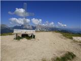
 | Rifugio Fedare - Monte Pore
Monte Pore or Spiz de Poure is a 2,405-meter-high grassy peak located west of the Averau and Nuvolau summits. From the top, where a large cross s...
1 h 30 min |
 | Eagles Nest - Mount Kosciuszko (Mt Kosciuszko Track)
Mount Kosciuszko is the highest mountain on mainland Australia, the easiest of the elite "Seven Summits", and it is also on the Ultra list. The m...
2 h |
 | Passo Campolongo - Stores
Stores is a 2,185-meter-high peak on the southeastern part of the Pralongia plateau. From the grassy summit where a cross stands, there is a very...
2 h |
 | Wiesser Alm - Mirnock (Path 184)
Mirnock is a 2,110 m high isolated and highly panoramic mountain massif in Carinthia. It is part of the Nockberge group in the Gurktal Alps, loca...
1 h 30 min |
 | parking below Weinebene - Steinmandl (Golica / Koralpe) (via Grünangerhütte)
Steinmandl is a panoramic peak in the Golica/Koralpe range, where numerous stone cairns have been built....
1 h 40 min |
 | Knödelhütte - Hirschegger Alm (southern peak)
The southern peak in the Hirschegger Alm ridge is located west of the settlement of Hirschegg. From the summit, where a cross stands, a beautiful...
1 h 35 min |
| Unterauerlinger Hütte - Hirschegger Alm (southern peak)
The southern peak in the Hirschegger Alm ridge is located west of the settlement of Hirschegg. From the summit, where a cross stands, a beautiful...
1 h 25 min |
 | Hebalm (Gasthaus Zur Rehbockhütte) - Barofen
Barofen is a panoramic peak between the Weinebene Pass and the mountain road to Hebalm. On its 1,720 m high summit stands a cross with a summit r...
2 h |
 | Weinebene Straße - Barofen
Barofen is a panoramic peak between the Weinebene Pass and the mountain road to Hebalm. On its 1,720 m high summit stands a cross with a summit r...
1 h 40 min |
| Gasthof Pfeifferstocker - Barofen
Barofen is a panoramic peak between the Weinebene Pass and the mountain road to Hebalm. On its 1,720 m high summit stands a cross with a summit r...
2 h |
 | Weinebene Straße - Renneiskogel
Renneiskogel is a lesser-known pathless peak in the Lavanttal Alps, north of the Weinebene Pass....
1 h 25 min |
| Gasthof Pfeifferstocker - Renneiskogel
Renneiskogel is a lesser-known pathless peak in the Lavanttal Alps, north of the Weinebene Pass....
1 h 45 min |
 | Nassfeld - Javornik / Auernig
Javornik (Italian Monte Auernig, German Auernig) is a 1864-meter-high peak above Mokrine on the border between Austria and Italy. The summit, cov...
1 h 30 min |
| Nassfeld - Javornik / Auernig (via Auernig Alm)
Javornik (Italian Monte Auernig, German Auernig) is a 1864-meter-high peak above Mokrine on the border between Austria and Italy. The summit, cov...
1 h 35 min |
 | Nassfeld - Garnitzenberg / Monte Carnizza (via Auernig Alm)
Krniška gora (Italian Monte Carnizza, German Garnitzenberg) is a 1950-meter-high mountain east of the Mokrine mountain pass. It is located on the...
1 h 50 min |
| Nassfeld - Garnitzenberg / Monte Carnizza (Auernig Höhenweg)
Krniška gora (Italian Monte Carnizza, German Garnitzenberg) is a 1950-meter-high mountain east of the Mokrine mountain pass. It is located on the...
2 h |
 | Kohlebnerstand - Windberg (northern path)
Windberg is a 1903-meter-high peak in the Schneealpe mountain group and, with its elevation, the highest peak of the group. From the summit, wher...
1 h 50 min |
| Kohlebnerstand - Windberg (southern path)
Windberg is a 1903-meter-high peak in the Schneealpe mountain group and, with its elevation, the highest peak of the group. From the summit, wher...
1 h 50 min |
 | Kohlebnerstand - Hoher Klapf
Hoher Klapf is a panoramic pathless peak in the Schneealpe mountain group, located near the group's highest peak, Windberg....
1 h 40 min |
 | Nassfeld - Kronalpe / Monte Corona
Koren (Italian Monte Corona, German Kronalpe) is a 1,832-meter-high peak east of the Mokrine Pass, more precisely above the Vrh Krnice saddle on ...
1 h 35 min |
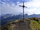
 | Raxalm-Berggasthof (Rax) - Preiner Wand (Rax)
Preiner Wand is a panoramic peak in the Rax mountain group, where a large cross stands....
1 h 40 min |
 | Panoramarestaurant Oben - Križnik (Peca)
Križnik is a 2,109-meter-high peak on Peca, located on the Austrian side of the mountain. From the summit, just a short way above the marked path...
1 h 40 min |
 | Seebergsattel - Seeleiten
Seeleiten is a panoramic peak with a cross on the Aflenzer Staritzen ridge, which belongs to the Hochschwab mountain group....
1 h 30 min |