 | Zali Log - Blegoš (via Potok)
Blegoš is a 1,562-metre-high mountain located between the Selška Sora and Poljanska Sora rivers. From the grassy summit, where there is a stamp a...
3 h |
 | Mače - Javorov vrh (Mačenska pot)
Javorov Vrh (recorded in some sources as Javorjev Vrh) is a 1,434 m high mountain northeast of Preddvor. The summit, with its registration box an...
2 h 55 min |
| Mače - Javorov vrh (via Kozjek)
Javorov Vrh (recorded in some sources as Javorjev Vrh) is a 1,434 m high mountain northeast of Preddvor. The summit, with its registration box an...
3 h 10 min |
 | Gornji Grad - Lepenatka (via Kal)
Lepenatka is a grassy peak located south of the 1557-metre-high Rogatec. From the summit, which has a summit register box and stamp, there is a b...
3 h |
 | Gornji Grad - Lepenatka (on ridge)
Lepenatka is a grassy peak located south of the 1557-metre-high Rogatec. From the summit, which has a summit register box and stamp, there is a b...
3 h |
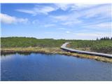
 | Podbrdo - Kobla
The summit is located in the Lower Bohinj Mountains between Črna prst and Soriška planina. Directly below it is a railway tunnel connecting Bohin...
3 h |
 | Podbrdo - Lajnar
Lajnar is a 1,549-metre-high mountain located north of Soriška Planina. From the summit, which is also the highest point of the ski resort, a bea...
2 h 55 min |
 | Podbrdo - Šavnik
Šavnik is a grassy peak situated between the ski resorts of Soriška Planina and Kobla. From the summit, which has a registration box with a stamp...
3 h |
 | Gornji Grad - Vivodnik (via Semprimožnik and Ovčji stan)
Vivodnik, at 1508 meters, is the highest peak of Menina planina, a plateau rising south of Gornji Grad. From the summit, which has a small observ...
3 h 30 min |
 | Lipa - Vivodnik
Vivodnik, at 1508 meters, is the highest peak of Menina planina, a plateau rising south of Gornji Grad. From the summit, which has a small observ...
3 h 30 min |
 | Tirosek (Nova Štifta) - Vivodnik
Vivodnik, at 1508 meters, is the highest peak of Menina planina, a plateau rising south of Gornji Grad. From the summit, which has a small observ...
4 h |
 | Gornji Grad - Vivodnik (past Strmčnik and cave Jespa)
Vivodnik, at 1508 meters, is the highest peak of Menina planina, a plateau rising south of Gornji Grad. From the summit, which has a small observ...
3 h 30 min |
| Gornji Grad - Vivodnik (via Borovnica and Ovčji stan)
Vivodnik, at 1508 meters, is the highest peak of Menina planina, a plateau rising south of Gornji Grad. From the summit, which has a small observ...
3 h 15 min |
| Gornji Grad - Vivodnik (via Borovnica and cave Jespa)
Vivodnik, at 1508 meters, is the highest peak of Menina planina, a plateau rising south of Gornji Grad. From the summit, which has a small observ...
3 h 25 min |
| Gornji Grad - Vivodnik (past Semprimožnik and cave Jespa)
Vivodnik, at 1508 meters, is the highest peak of Menina planina, a plateau rising south of Gornji Grad. From the summit, which has a small observ...
3 h 40 min |
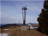
 | Vitanje - Rogla
Rogla is a peak in the middle of the eponymous ski resort. The peak is forested with a small clearing on which stands a lookout tower. The tower ...
4 h |
 | Mislinja - Rogla (via Tolsti Vrh)
Rogla is a peak in the middle of the eponymous ski resort. The peak is forested with a small clearing on which stands a lookout tower. The tower ...
4 h 15 min |
 | Lovrenc na Pohorju - Rogla
Rogla is a peak in the middle of the eponymous ski resort. The peak is forested with a small clearing on which stands a lookout tower. The tower ...
4 h 30 min |
 | Lovrenc na Pohorju - Lovrenška jezera
The Lovrenška jezera are located on a high bog in the middle of Pohorje between Rogla and Ribniško Pohorje. The smaller lakes, which receive wate...
3 h 35 min |
 | Mislinja - Mali Črni vrh
Mali Črni vrh is located above the Ribniška koča mountain hut. At the top, there is an artificial lake intended for snowmaking. From the top, the...
2 h 55 min |
 | Dovže - Črni vrh
Črni vrh is the highest peak of Pohorje. Because it is partly unvegetated, it offers a nice view toward Velika Kopa, Uršlja gora, and in the back...
3 h 45 min |
 | Dovže - Velika Kopa
Velika Kopa is a 1542-meter-high peak located between Grmovškov dom and the nearby Mala Kopa. From the top, which is only 1 meter lower than the ...
3 h 15 min |
 | Matke - Mrzlica (via Kočet and Kriška planina)
In recent years, Mrzlica has become an extremely popular excursion spot, especially for visitors from Savinjska valley and Zasavje. At 1,122 mete...
2 h 50 min |
 | Podbrdo - Krevl
Krevl is a 1515-meter-high peak situated south of the Kobla ski area, more precisely between the Kobla peak and Kravja Črna gora. From the summit...
3 h 15 min |
 | Bohinjska Bistrica - Krevl (via Planina za Črno goro)
Krevl is a 1515-meter-high peak situated south of the Kobla ski area, more precisely between the Kobla peak and Kravja Črna gora. From the summit...
2 h 55 min |
 | Bistriški jarek (border crossing Muta) - Huhnerkogel/Košenjak (via Bivak Piramida)
Košenjak is located north of Dravograd and the Drava River on the border with neighbouring Austria. Access to Košenjak is possible on foot or by ...
4 h 50 min |
| Bistriški jarek (border crossing Muta) - Huhnerkogel/Košenjak (via Sveti Urban)
Košenjak is located north of Dravograd and the Drava River on the border with neighbouring Austria. Access to Košenjak is possible on foot or by ...
4 h 35 min |
| Bistriški jarek (Glasbeni dom) - Huhnerkogel/Košenjak (via Bivak Piramida)
Košenjak is located north of Dravograd and the Drava River on the border with neighbouring Austria. Access to Košenjak is possible on foot or by ...
4 h 45 min |
| Bistriški jarek (Glasbeni dom) - Huhnerkogel/Košenjak (via Sveti Urban)
Košenjak is located north of Dravograd and the Drava River on the border with neighbouring Austria. Access to Košenjak is possible on foot or by ...
4 h 30 min |
 | Podmeja - Črni vrh (Čemšeniška planina)
Črni vrh is the highest peak of Čemšeniška planina and, at 1,204 m, the second-highest peak in Posavsko hribovje. The summit has a logbook box bu...
3 h 30 min |
| Dom pod Reško planino - Črni vrh (Čemšeniška planina)
Črni vrh is the highest peak of Čemšeniška planina and, at 1,204 m, the second-highest peak in Posavsko hribovje. The summit has a logbook box bu...
3 h |
 | Kopačnica - Bevkov vrh
Bevkov vrh, a control point on the Slovenian Mountain Trail, is located between Cerkno and Spodnja Idrija. The peak is forested, but the stamp is...
3 h 40 min |
 | Lovrenc na Pohorju - Klopni vrh (via Spodnji trg and on northern path)
From the northwest, Klopni vrh closes off the lower-lying extensive plateau on eastern Pohorje. The horizontal cross-sectional area at 1300 m is ...
3 h 5 min |
| Lovrenc na Pohorju - Klopni vrh (via Spodnji trg and on eastern path)
From the northwest, Klopni vrh closes off the lower-lying extensive plateau on eastern Pohorje. The horizontal cross-sectional area at 1300 m is ...
3 h 5 min |
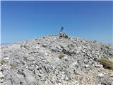
 | Kočevska Reka - Goteniški Snežnik
At 1,289 meters, Goteniški Snežnik is the highest peak of Goteniška gora. The forested summit offers a somewhat obstructed view. It has a logbook...
3 h 15 min |
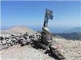
 | Gornji Grad - Špic (via Semprimožnik)
Špic is a 1,499-meter-high peak located right next to the Dom na Menini planini mountain hut. From the summit, near which transmitters are locate...
3 h 15 min |
 | Bezgovica - Cerk
Cerk, at 1,192 meters, is the highest peak of Borovška gora, a range situated between the Kolpa River valley and Goteniški Snežnik. From the summ...
2 h 55 min |
 | Rakitnica - Turn
Turn is the 1254 m highest peak of the 14 km long Velika gora plateau, rising between Ribniško polje and Liški potok. Despite partial tree cover,...
3 h |
 | Dolenji Novaki - Medrce
Medrce is a 1,410-meter-high peak located between Porezen and Hum. From the summit, which features an old bunker, there are nice views of Kojca, ...
3 h 15 min |
 | Slovenska vas - Ledenik
Ledenik, at 1,072 meters, is the highest peak of Stojna, a forested ridge situated between Kočevje and Kočevska Reka. On the summit there is a lo...
3 h 15 min |
 | Mislinja - Ostruščica (via Tolsti Vrh)
Ostruščica is a 1,498-meter-high peak located west of the ski slopes on Rogla....
4 h 15 min |
 | Bistriški jarek (border crossing Muta) - Kozji vrh (at Košenjak)
Kozji vrh is a 1,383-meter-high peak located above Pernice; it is also the highest peak in the Municipality of Muta....
2 h 50 min |
 | Bled (Velika Zaka) - Berjanca
Berjanca is a 1,264 m high peak above the namesake mountain pasture. An abandoned ski lift from the former Zatrnik ski area used to reach the sum...
3 h 10 min |
| Bohinjska Bela (St. Marjeta) - Berjanca
Berjanca is a 1,264 m high peak above the namesake mountain pasture. An abandoned ski lift from the former Zatrnik ski area used to reach the sum...
2 h 55 min |
 | Lovrenc na Pohorju - Pesek
Pesek is a 1,423-meter-high peak on Pohorje, located above Koča na Pesku....
4 h 8 min |
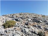
 | Kosmadei - Vigla (Kerkis) (Samos) (no. 11 / 10)
Vigla is at 1,443 m the highest peak of Mount Kerkis on the Greek island of Samos.There are several interesting spots on and near the mountain of...
4 h 15 min |
 | Kosmadei - Vigla (Kerkis) (Samos) (no. 9 / 10)
Vigla is at 1,443 m the highest peak of Mount Kerkis on the Greek island of Samos.There are several interesting spots on and near the mountain of...
5 h |
 | Kosmadei - Zastano (Samos) (no. 11 / 10)
Zastano (Gr. Ζάστανο), also Zestani (Gr. Ζεστάνι), is at 1,206 m the second-highest mountain on the Greek island of Samos. It is located in the K...
3 h 10 min |