 | Preval - Sveti Jakob
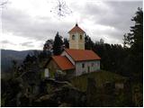
The Church of St. James is located on a scenic hill north of the village of Topol pri Medvodah. From the summit, which features a registration bo...
2 h 5 min |
 | Preska - Sveti Jakob (via Turnice)
The Church of St. James is located on a scenic hill north of the village of Topol pri Medvodah. From the summit, which features a registration bo...
3 h |
| Žlebe - Sveti Jakob (via Turnice)
The Church of St. James is located on a scenic hill north of the village of Topol pri Medvodah. From the summit, which features a registration bo...
2 h |
| Preska - Sveti Jakob (via Jeterbenk)
The Church of St. James is located on a scenic hill north of the village of Topol pri Medvodah. From the summit, which features a registration bo...
3 h 15 min |
| Žlebe - Sveti Jakob (via Jeterbenk)
The Church of St. James is located on a scenic hill north of the village of Topol pri Medvodah. From the summit, which features a registration bo...
2 h 15 min |
 | Slavkov dom na Golem Brdu - Sveti Jakob
The Church of St. James is located on a scenic hill north of the village of Topol pri Medvodah. From the summit, which features a registration bo...
2 h 5 min |
 | Phliški bajer - Rašica (Vrh Staneta Kosca) (ridge path)
Vrh Staneta Kosca, better known as Rašica, is located north of Ljubljana, more precisely above the villages of Rašica and Dobeno. From the summit...
2 h |
| Topole - Rašica (Vrh Staneta Kosca) (ridge path)
Vrh Staneta Kosca, better known as Rašica, is located north of Ljubljana, more precisely above the villages of Rašica and Dobeno. From the summit...
2 h 10 min |
| Mengeška koča na Gobavici - Rašica (Vrh Staneta Kosca) (ridge path)
Vrh Staneta Kosca, better known as Rašica, is located north of Ljubljana, more precisely above the villages of Rašica and Dobeno. From the summit...
2 h |
 | Mengeška koča na Gobavici - Rašica (Vrh Staneta Kosca) (lower path)
Vrh Staneta Kosca, better known as Rašica, is located north of Ljubljana, more precisely above the villages of Rašica and Dobeno. From the summit...
2 h |
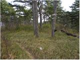
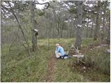
 | Preval - Jeterbenk
Jeterbenk is a 774-meter-high peak located between the Slavkov dom hut on Golo Brdo and Katarina (the village of Topol). From the summit, where t...
2 h 5 min |
 | Preska - Jeterbenk (via Turnice)
Jeterbenk is a 774-meter-high peak located between the Slavkov dom hut on Golo Brdo and Katarina (the village of Topol). From the summit, where t...
2 h 15 min |
 | Preska - Jeterbenk (on ridge)
Jeterbenk is a 774-meter-high peak located between the Slavkov dom hut on Golo Brdo and Katarina (the village of Topol). From the summit, where t...
2 h 15 min |
 | Kandrše (Trata) - Limbarska gora
Limbarska gora is located northeast of Moravče. From the summit, there is a beautiful view of the surrounding peaks, and in good weather, the Kam...
3 h 15 min |
| Blagovica - Limbarska gora (Blagovica - Limbarska gora - Blagovica)
Limbarska gora is located northeast of Moravče. From the summit, there is a beautiful view of the surrounding peaks, and in good weather, the Kam...
2 h 9 min |
 | Vrhnika-Tankovska cesta - Koča na Planini nad Vrhniko (Circular path Vrhnika-Planina-Lintvern-Vrhnika)
Planina nad Vrhniko is for Vrhnika locals something like Šmarna gora for those from Ljubljana. It is 733 m high, reachable by several paths from ...
2 h 20 min |
 | Besnica - Janče
Janče is a 792-meter-high peak situated between the Sava River and the Besnica stream valley. From the summit, where a mountain hut stands and th...
2 h 15 min |
 | Laze pri Dolskem - Janče
Janče is a 792-meter-high peak situated between the Sava River and the Besnica stream valley. From the summit, where a mountain hut stands and th...
2 h 15 min |
 | Kamnica - Sveti Miklavž above Sava (via Velika vas)
The Church of St. Miklavž is situated on a panoramic hill south of Moravče. From the summit, there is a beautiful view toward the nearby Limbarsk...
2 h 5 min |
 | Polzela - Gora Oljka (via Vimperk)
Gora Oljka is a hill located east of Šmartno ob Paki. On the summit stands the Church of the Holy Cross, built in the mid-18th century. Just a fe...
2 h 15 min |
 | Črni hribi - Trstelj
Trstelj is the highest peak in the ridge of Črni hribi. From the spacious summit, which has TV transmitters, the view is divided. From the north ...
2 h |
 | Pedrovo - Trstelj
Trstelj is the highest peak in the ridge of Črni hribi. From the spacious summit, which has TV transmitters, the view is divided. From the north ...
2 h |
 | Preska - Rog (via Turnice)
Rog is an 798-meter peak above the village of Topol, just 10 minutes from St. Katarina's Church. From the summit, where a large cross once stood,...
2 h 30 min |
| Preska - Rog (via Jeterbenk)
Rog is an 798-meter peak above the village of Topol, just 10 minutes from St. Katarina's Church. From the summit, where a large cross once stood,...
2 h 45 min |
 | Kozjak nad Pesnico - Tojzlov vrh
Tojzlov vrh is a forested hill on the eastern part of Kozjak. On the summit stands a small stone NOB monument and, more recently, also a summit l...
2 h 5 min |
 | Gorjuša - Murovica (via Dobovlje)
Murovica is a popular excursion point, accessible from the Posavje side, Domžale, or the Moravška Valley. On the summit there is a bench and a lo...
2 h 40 min |
 | Senožeti - Murovica (via Vrh pri Dolskem)
Murovica is a popular excursion point, accessible from the Posavje side, Domžale, or the Moravška Valley. On the summit there is a bench and a lo...
2 h 5 min |
 | Lokvica - Lešenjak
Lešenjak, at 552 meters, is among the highest peaks in the Črnih hribov ridge. Near the summit, which has a summit logbox, there are numerous tun...
2 h 45 min |
 | Lokvica - Stolovec
Stolovec is a forest-covered peak located west of the better-known Trstelj. The summit has a summit logbox but no stamp....
3 h 15 min |
 | Kandrše (Trata) - Golčaj
Golčaj is a 690 m high hill rising south of Blagovica. At the summit, which has a logbook box and stamp, stands a NOB monument; a few tens of met...
3 h 20 min |
 | Sveti Mavricij - Sveti Socerb (Artviže)
The Church of St. Socerb is located on a panoramic hill above the village of Artviže, which at 817 meters is the highest peak of the Brkini. From...
2 h 15 min |
 | Kozje - Brest (Bohor) (via Vetrnik)
Brest is a peak on Bohor, though it resembles more of a saddle. It is an important trail junction on Bohor, lying between more easterly Oslica an...
2 h |
 | Stari trg (Pilštanj) - Brest (Bohor)
Brest is a peak on Bohor, though it resembles more of a saddle. It is an important trail junction on Bohor, lying between more easterly Oslica an...
2 h 45 min |
 | Ponikva/Hotunje - Babček (via Sveta Uršula)
Babček is an indistinct peak on the hiking trail between Konjiška gora and Boč. An asphalt road runs practically right below the summit. There ar...
2 h 45 min |
 | Studenice - Plešivec (at Boč)
Peace, silence, varied terrain... these are characteristics of the peak at the crossroads of numerous paths between the Maribor, Celje, and Ptuj ...
2 h |
 | Studenice - Plešivec (at Boč) (final part on forest road)
Peace, silence, varied terrain... these are characteristics of the peak at the crossroads of numerous paths between the Maribor, Celje, and Ptuj ...
2 h |
 | Planinski dom Milana Šinkovca - Šenturška Gora
Šenturška Gora is a settlement located between Tunjiško gričevje and Krvavec. From the church, the village, or nearby agritourism, nice views ope...
2 h 15 min |
| Planinski dom Milana Šinkovca - Šenturška Gora (via Zaloški rob)
Šenturška Gora is a settlement located between Tunjiško gričevje and Krvavec. From the church, the village, or nearby agritourism, nice views ope...
2 h 15 min |
 | Muta (Spodnja Muta) - Sveti Trije Kralji (above Radlje ob Dravi)
The Church of the Holy Three Kings is located on an 820-meter-high hill rising above the right bank of the Radeljski Stream. From the church, a n...
2 h 30 min |
 | Radlje ob Dravi - Sveti Anton na MP Radelj / St. Anton am Radlpaß (via old castle)
The Church of St. Anton at the Radelj border crossing / St. Anton am Radlpaß is located on the Austrian side of Kozjak on a 720-meter-high hill r...
2 h 15 min |
 | Dravograd (Meža) - Anski vrh (above Pameče)
Anski vrh is a panoramic peak above Pameče, crowned by the Church of St. Anne. From the church or its surroundings, nice views open towards Uršlj...
3 h |
 | Loka pri Žusmu (Žamerk) - Plešivec (Rudnica)
Plešivec is a forest-covered peak on Rudnica, its highest point. The summit has a summit register box, a bench, and a table....
2 h |