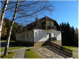
 | Koča pri Savici - Dom na Komni
The Dom na Komni, open all year round, is located on a subtle scenic rise west of Lake Bohinj. The hut is clearly visible from the lake and its s...
2 h 30 min |
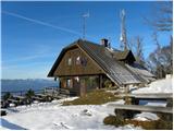
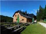
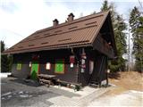
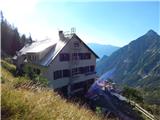
 | Tržič - Koča na Kriški gori
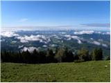
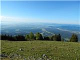
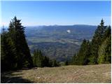
The mountain hut is located on the western side of Kriška gora. Since there is no forest to the south and west of the hut, there is a beautiful v...
2 h 15 min |
 | Golnik - Koča na Kriški gori
The mountain hut is located on the western side of Kriška gora. Since there is no forest to the south and west of the hut, there is a beautiful v...
2 h 30 min |
 | Križe - Koča na Kriški gori (steep path)
The mountain hut is located on the western side of Kriška gora. Since there is no forest to the south and west of the hut, there is a beautiful v...
2 h 40 min |
| Križe - Koča na Kriški gori (easier path)
The mountain hut is located on the western side of Kriška gora. Since there is no forest to the south and west of the hut, there is a beautiful v...
2 h 45 min |
| Zalog - Koča na Kriški gori
The mountain hut is located on the western side of Kriška gora. Since there is no forest to the south and west of the hut, there is a beautiful v...
2 h 50 min |
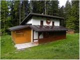
 | Zadnja vas - Koča na Dobrči
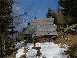
The mountain hut stands on the edge of the steep southern slope of Dobrča, offering an outstanding view eastward towards Kriška gora, Storžič and...
2 h 30 min |
 | Hudi Graben - Koča na Dobrči
The mountain hut stands on the edge of the steep southern slope of Dobrča, offering an outstanding view eastward towards Kriška gora, Storžič and...
2 h 30 min |
| Slatna - Koča na Dobrči
The mountain hut stands on the edge of the steep southern slope of Dobrča, offering an outstanding view eastward towards Kriška gora, Storžič and...
2 h 30 min |
 | Begunje (Preska) - Koča na Dobrči
The mountain hut stands on the edge of the steep southern slope of Dobrča, offering an outstanding view eastward towards Kriška gora, Storžič and...
2 h 30 min |
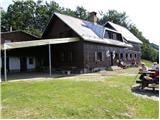
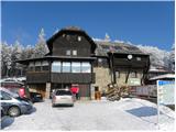
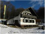
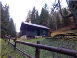
 | Tržič (Slap) - Dom pod Storžičem
Dom pod Storžičem is a mountain hut located northwest of Storžič, near the Jesenje mountain pasture. Mostly surrounded by forest, the hut offers ...
2 h 15 min |
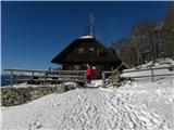
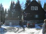
 | Gornji Grad - Bivak na Kalu
Bivak na Kalu is located at the foot of the steep slopes of the 1557-metre-high Rogatec. From the bivouac, owned by PD Gornji Grad, there is a be...
2 h 35 min |
 | Poljana (Završnica) - Valvasorjev dom pod Stolom (by road)
The mountain hut, managed by PD Radovljica, is located below the highest peak of the Karawanks. It is accessible by car, but the nearby forest si...
1 h 45 min |
 | Volaka - Zavetišče gorske straže na Jelencih
The shelter is located in a small clearing in the middle of the forest below Blegoš. Due to the nearby forest, there is no view of the surroundin...
1 h 35 min |
 | Javorje (Mala Črna) - Dom na Smrekovcu (via Bukov stan)
The Dom na Smrekovcu mountain hut is located below the summit of Smrekovec on the eastern edge of the Smrekovško pogorje range. Due to the nearby...
2 h 45 min |
 | Javorje (Mala Črna) - Dom na Smrekovcu (by road)
The Dom na Smrekovcu mountain hut is located below the summit of Smrekovec on the eastern edge of the Smrekovško pogorje range. Due to the nearby...
2 h 45 min |
 | Dovže - Grmovškov dom pod Veliko Kopo
Grmovškov dom pod Veliko Kopo is situated below the Pungart saddle, which lies between Velika Kopa (1542 m) and the less distinct peak Otiše (141...
2 h 45 min |
 | Smolnik (Marotov most) - Posestvo Šumik (through valley of Lobnica)
Posestvo Šumik is located in the immediate vicinity of the Šumik nature reserve with the Lobnica valley and the Mali and Veliki Šumik waterfalls....
2 h 35 min |
 | Žekovec - Mozirska koča na Golteh
The Mozirska koča hut is located southwest of Boskovec, the highest peak of the Golte plateau. As the area around the hut is mostly forested, vie...
2 h 15 min |
 | Radegunda (Žekovec) - Mozirska koča na Golteh (via Zagradiška puša)
The Mozirska koča hut is located southwest of Boskovec, the highest peak of the Golte plateau. As the area around the hut is mostly forested, vie...
2 h 15 min |
 | Dravograd - Dom na Košenjaku
The Dom na Košenjaku mountain hut is situated north of Dravograd on the southern slopes of Košenjak. The view from the hut is mainly limited to t...
2 h 30 min |
 | Gradišče - Koča pod Kremžarjevim vrhom
The mountain hut is located west of Kremžarjev vrh, just a few minutes' walk away. From the hut, a point on the Slovenian Mountain Trail, Uršlja ...
1 h 45 min |
 | Legen (Vinišnik) - Koča pod Kremžarjevim vrhom (čez Kremžarjev vrh)
The mountain hut is located west of Kremžarjev vrh, just a few minutes' walk away. From the hut, a point on the Slovenian Mountain Trail, Uršlja ...
1 h 40 min |
| Slovenj Gradec - Koča pod Kremžarjevim vrhom
The mountain hut is located west of Kremžarjev vrh, just a few minutes' walk away. From the hut, a point on the Slovenian Mountain Trail, Uršlja ...
2 h 5 min |
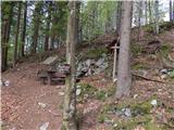
 | Drežnica - Bivak na Črniku
Bivak na Črniku is located west of the mighty Krn, along the lower part of the Silvo Koren path. Surrounded by forest, it offers no view but prov...
1 h 45 min |
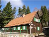
 | Trojane - Koča na Čemšeniški planini
The Dom dr. Franca Goloba mountain hut on Čemšeniška planina is located at the edge of a large grassy area from which a fine view opens toward Za...
2 h 30 min |
| Jelševica - Koča na Čemšeniški planini
The Dom dr. Franca Goloba mountain hut on Čemšeniška planina is located at the edge of a large grassy area from which a fine view opens toward Za...
2 h 30 min |
 | Dolina Zaplaninščice - Koča na Čemšeniški planini
The Dom dr. Franca Goloba mountain hut on Čemšeniška planina is located at the edge of a large grassy area from which a fine view opens toward Za...
2 h 40 min |
 | Col - Pirnatova koča na Javorniku
The Pirnatova koča mountain hut on Javornik is located on the eastern slopes of the summit. Nearby is a large meadow offering fine views to the e...
2 h 50 min |
 | Pivola (Reka) - Mariborska koča (via Petkovo sedlo and waterfall Skalca)
Mariborska koča is the first control point of the Slovenian Mountain Trail (SPP). It is located north of Slivniško Pohorje and west of Hočko Poho...
2 h 30 min |
 | Pivola (Reka) - Mariborska koča (via Hočka koča)
Mariborska koča is the first control point of the Slovenian Mountain Trail (SPP). It is located north of Slivniško Pohorje and west of Hočko Poho...
2 h 15 min |
 | Log - Mariborska koča
Mariborska koča is the first control point of the Slovenian Mountain Trail (SPP). It is located north of Slivniško Pohorje and west of Hočko Poho...
2 h 40 min |
 | Pivola (Reka) - Mariborska koča (via Petkovo sedlo)
Mariborska koča is the first control point of the Slovenian Mountain Trail (SPP). It is located north of Slivniško Pohorje and west of Hočko Poho...
2 h 15 min |
 | Veliko Tinje - Sveti Trije kralji
Sveti Trije Kralji is a popular excursion spot for Styrian and other mountaineers. Near the Church of the Holy Three Kings is the Jakec guesthous...
2 h |
 | Oplotnica - Sveti Trije kralji
Sveti Trije Kralji is a popular excursion spot for Styrian and other mountaineers. Near the Church of the Holy Three Kings is the Jakec guesthous...
2 h 45 min |
 | Činžat - Koča na Klopnem vrhu
The mountain hut stands on a panoramic clearing northeast of Klopni vrh. The pre-war hut was burned down by partisans in 1941 to prevent the occu...
2 h 30 min |
| Lovrenc na Pohorju - Koča na Klopnem vrhu (via spodnji trg)
The mountain hut stands on a panoramic clearing northeast of Klopni vrh. The pre-war hut was burned down by partisans in 1941 to prevent the occu...
2 h 50 min |
| Lovrenc na Pohorju - Koča na Klopnem vrhu (via Zgornji trg)
The mountain hut stands on a panoramic clearing northeast of Klopni vrh. The pre-war hut was burned down by partisans in 1941 to prevent the occu...
2 h 30 min |
 | Leše - Koča na Naravskih ledinah (via Kot pri Prevaljah)
Koča na Naravskih ledinah is located on the northern side of the western ridge of Uršlja gora. The hut, accessible by car, offers no views due to...
2 h 40 min |
| Prevalje - Koča na Naravskih ledinah (by road)
Koča na Naravskih ledinah is located on the northern side of the western ridge of Uršlja gora. The hut, accessible by car, offers no views due to...
2 h 55 min |
 | Spodnja Kokra - Zavetišče v Hudičevem borštu
In the middle of the southern slopes of Cjanovca (the slopes of Zaplata), which is a secondary peak of the better-known Srednji vrh, lies an inte...
2 h 55 min |
 | Mače - Zavetišče v Hudičevem borštu (Mačenska pot)
In the middle of the southern slopes of Cjanovca (the slopes of Zaplata), which is a secondary peak of the better-known Srednji vrh, lies an inte...
1 h 55 min |
| Mače - Zavetišče v Hudičevem borštu (via Kozjek)
In the middle of the southern slopes of Cjanovca (the slopes of Zaplata), which is a secondary peak of the better-known Srednji vrh, lies an inte...
2 h 10 min |
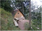
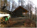
 | Podbrdo - Lovčev bivak Pri Koucah
Lovčev bivak Pri Koucah is a sort of hunting cabin (not used as a bivouac) located on a small clearing on the otherwise steep southwestern slopes...
1 h 55 min |
 | Drežnica - Italian military chapel on Planica
The Italian military chapel on Planica (also known as the Bes chapel) is located above a small cliff between Planica and Pleče. From the chapel, ...
2 h |
 | Tržič - Zavetišče na Kalu (via Kamnek)
The Zavetišče na Kalu shelter is located on the edge of the namesake saddle, more precisely between the Bela peč and Kobel peaks. From the saddle...
2 h 40 min |
 | Tržič (Čegelše) - Zavetišče na Kalu
The Zavetišče na Kalu shelter is located on the edge of the namesake saddle, more precisely between the Bela peč and Kobel peaks. From the saddle...
2 h |
 | Hinterstoder - Prielschutzhaus
Prielschutzhaus mountain hut is situated at an altitude of 1420 meters in the Totes Gebirge mountain group below the slopes of the highest peak G...
2 h 15 min |
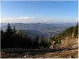
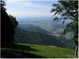
 | Parking above Scuglielârs - Mali Karman / Monte Cuarnan (CAI 717 - 715)
Mali Karman is the first more prominent rise in the far southwestern foothills of the Julian Alps. It lies parallel to the main ridge of Veliki K...
2 h 30 min |
 | Mežica - Bivak Suška bajta
Bivak Suška bajta is located between Suški vrh and Kot pri Prevaljah. Nearby Suška bajta there are numerous verses, figures of Tomažej (Tomažej -...
2 h 45 min |
 | Bistriški jarek (border crossing Muta) - Church of St. Simon and Judah Tadej (Pernice)
Pernice is a settlement located between Gortina, Kozji vrh and Bistriški jarek. In Pernice there is the church of St. Simon and Jude Thaddeus, a ...
1 h 50 min |
| Bistriški jarek (Glasbeni dom) - Church of St. Simon and Judah Tadej (Pernice)
Pernice is a settlement located between Gortina, Kozji vrh and Bistriški jarek. In Pernice there is the church of St. Simon and Jude Thaddeus, a ...
1 h 45 min |
 | Muta (Zgornja Muta) - Church of St. Simon and Judah Tadej (Pernice)
Pernice is a settlement located between Gortina, Kozji vrh and Bistriški jarek. In Pernice there is the church of St. Simon and Jude Thaddeus, a ...
2 h 45 min |
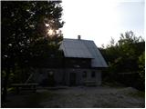
 | Bled (Velika Zaka) - Forestry cottage Mali Vokel
The forestry cottage Mali Vokel is located on the eastern slopes of Pokljuka, specifically along the marked trail from Bled to Pokljuka. There ar...
2 h 50 min |
| Bohinjska Bela (St. Marjeta) - Forestry cottage Mali Vokel
The forestry cottage Mali Vokel is located on the eastern slopes of Pokljuka, specifically along the marked trail from Bled to Pokljuka. There ar...
2 h 35 min |
 | Bohinjska Bela (St. Marjeta) - Hunting cottage Mali Vokel
The hunting cottage Mali Vokel lies along the marked trail from Bled to Pokljuka, between Rčitno and the Rečiška mountain pasture....
2 h 45 min |
 | Kropa - Partisan cyclostyle Tehnika Meta (via Berigla)
The partisan printing press Tehnika Meta on Jelovica is located at approximately 1,100 m elevation. At the site of the former Tehnika Meta there ...
1 h 50 min |
 | Vitanje - Chapel of Mary's Hand (Stenica)
The Chapel of Mary's Hand is located a few minutes below the summit of Stenica on Mala gora, which rises steeply above the settlement of Vitanje....
1 h 40 min |
 | Pivola (Reka) - Sveti Bolfenk (Mariborsko Pohorje) (via Petkovo sedlo and Mariborska koča)
The Church of St. Bolfenk on Mariborsko Pohorje is located near the upper station of the funicular and near the Hotel Bellevue....
2 h 50 min |
 | Glavaš - Planinsko zavetišče Martinova Košara
The Martinova Košara mountain shelter is situated in the middle of the vast grassy field of Donje Torine on the slopes of Jančje glavica, below C...
2 h 30 min |
 | Radegunda (Žekovec) - Ledenica na Golteh (via Zagradiška puša)
The Golte ice cave is just a few dozen steps off the marked trail leading from Mozirska Koča na Golteh to Dom na Smrekovcu....
2 h 25 min |
 | Bistriški jarek (Glasbeni dom) - Arl's Pine
Arlov bor has been protected since 2010 as a local, municipal, and natural landmark due to its unique and unusual growth.From the pine, where a v...
2 h |
| Bistriški jarek (border crossing Muta) - Arl's Pine
Arlov bor has been protected since 2010 as a local, municipal, and natural landmark due to its unique and unusual growth.From the pine, where a v...
2 h 5 min |
| Muta (Zgornja Muta) - Arl's Pine
Arlov bor has been protected since 2010 as a local, municipal, and natural landmark due to its unique and unusual growth.From the pine, where a v...
2 h 30 min |
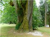 | Črna na Koroškem - Najevska lipa
The Najevska linden, regarded as Slovenia's thickest tree for decades, stands in Ludranski Vrh in the Municipality of Črna na Koroškem. It is a s...
2 h 10 min |