 | Nuskova - Serdiški breg (Rdeči breg)
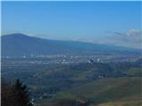
Serdiški breg (Rdeči breg) is a 416 m high hill located right next to the Austrian border. From its grassy summit, which has a few benches and a ...
50 min |
| Nuskova - Serdiški breg (Rdeči breg) (via Brunarjev breg)
Serdiški breg (Rdeči breg) is a 416 m high hill located right next to the Austrian border. From its grassy summit, which has a few benches and a ...
1 h |
| Serdica - Serdiški breg (Rdeči breg) (via Brunarjev breg)
Serdiški breg (Rdeči breg) is a 416 m high hill located right next to the Austrian border. From its grassy summit, which has a few benches and a ...
50 min |
 | Dolena (Stojana vas) - Janški vrh
Janški vrh is a 417-meter-high peak on which stands a small namesake settlement and the Church of St. John the Baptist from the 15th century. The...
50 min |
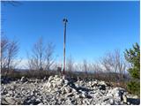
 | Sotina - Sotinski breg (Kugla) (via the source of mineral water)
Sotinski breg (Kugla) is the highest peak of Prekmurje at 418 m. From the summit, which features a wooden observation tower with a bell and cross...
50 min |
 | Pernica - Vavtošek
Vavtošek is a scenic summit in the Slovenske Gorice on which several transmitters stand. From the top there is a fine view mainly towards the sou...
1 h 5 min |
 | Lokvica - Fajti hrib
Fajti, also known in some records as Fajtji hrib, is a 433-meter-high hill located in the Črni hribi ridge. The summit is known mainly for the fi...
1 h |
 | Phliški bajer - Mengeška koča on Gobavica (ridge path)
Gobavica is a hill rising above Mengeš. Mengeška koča mountain hut stands on it, along with a goat pen. It is one of the starting points for the ...
1 h 10 min |
 | Phliški bajer - Mengeška koča on Gobavica (lower path)
Gobavica is a hill rising above Mengeš. Mengeška koča mountain hut stands on it, along with a goat pen. It is one of the starting points for the ...
1 h |
 | Vojnik - Sveti Tomaž above Vojnik
Sv. Tomaž is a church on a partly vegetated 444 m high summit near Vojnik. There is a logbook with a stamp at the top. Below the summit stands th...
1 h |
 | Ljubljana (Gruberjeva brv) - Mazovnik (Golovec)
Mazovnik, at 450 m, is the highest peak of Golovec, a hill range located on the southeastern outskirts of Ljubljana. Golovec remained bare until ...
1 h |
 | Ljubljana (Žabja vas) - Orle
Orle is a settlement in the Municipality of Škofljica, located on a small hill northeast of the Ljubljana Marshes. A few meters below the highest...
1 h 15 min |
| Ljubljana (Sveti Urh) - Orle
Orle is a settlement in the Municipality of Škofljica, located on a small hill northeast of the Ljubljana Marshes. A few meters below the highest...
1 h 10 min |
 | Stainz bei Straden - Rosenberg
Rosenberg is a panoramic peak located south of the Aussichtswarte Vulkanland observation tower, or just slightly above the settlement of Rožni Vr...
1 h 10 min |
 | Suhadole - Koseški hrib (via Mlinčki)
Koseški hrib is located between Kuharjev boršt and Koseze, the settlement after which the peak is also named. From the summit, which has a table,...
50 min |
| Bukovica pri Vodicah - Koseški hrib (via Mlinčki)
Koseški hrib is located between Kuharjev boršt and Koseze, the settlement after which the peak is also named. From the summit, which has a table,...
50 min |
 | Topole - Koseški hrib
Koseški hrib is located between Kuharjev boršt and Koseze, the settlement after which the peak is also named. From the summit, which has a table,...
55 min |
 | Stainz bei Straden - Aussichtswarte Vulkanland (Um die Mitte)
The 41-meter-high lookout tower Aussichtswarte Vulkanland (or Aussichtswarte Frutten-Gießelsdorf) is located above the settlement Frutten-Gießels...
1 h 30 min |
 | Snack Bar Zelena dolina - Church of Our Lady of Loreto in Ložno
The Church of Our Lady of Loreto at Ložno stands on a panoramic hill northeast of Rogaška Slatina. A chapel and an NOB monument stand by the chur...
1 h 5 min |
| Brzika - Church of Our Lady of Loreto in Ložno
The Church of Our Lady of Loreto at Ložno stands on a panoramic hill northeast of Rogaška Slatina. A chapel and an NOB monument stand by the chur...
55 min |
 | Brezje pri Dobrovi - Vrhovčev grič (via Strmca)
Vrhovčev grič is an indistinct, forested peak located just a few meters off the marked trail between Debeli hrib and Strmca....
50 min |
| Dragomer (bajer) - Vrhovčev grič (via Ferjanka and Strmca)
Vrhovčev grič is an indistinct, forested peak located just a few meters off the marked trail between Debeli hrib and Strmca....
1 h 10 min |
 | Zazid - Kuk
Kuk (also known as Ščukovec on some maps) is a 498-meter-high hill north of the village Movraž. From the summit, which features a small cross, th...
1 h |
 | Loka pri Žusmu (Žamerk) - Castle Žusem
Castle Žusem (German Sussenheim), of which only ruins remain today, is located east to northeast of Žusem, a peak with a lookout tower....
50 min |
 | Šentilj v Slovenskih goricah - Plački vrh
Plački vrh is a peak in Slovenske Gorice. It lies in the municipality of Kungota, right on the border with Austria.A 28-meter-high lookout tower ...
1 h |
 | Repnje - Smledniški hrib (Stari grad)
Stari grad (also known as Smlednik Castle) is located on a small hill southwest of Valburga. In recent years, the castle has been renovated and n...
1 h 15 min |
 | Stari trg (Pilštanj) - Vina gora (zahodna pot)
Vina Gora is a scenic hill rising east of the medieval market town of Pilštanj. Its summit has been converted into an attractive open-air museum ...
55 min |
| Lesično - Vina gora (zahodna pot)
Vina Gora is a scenic hill rising east of the medieval market town of Pilštanj. Its summit has been converted into an attractive open-air museum ...
55 min |
| Lesično - Vina gora (along the water educational trail and along the western path)
Vina Gora is a scenic hill rising east of the medieval market town of Pilštanj. Its summit has been converted into an attractive open-air museum ...
55 min |
 | Dom Frata - Ostri vrh (above Globodol)
Ostri vrh is a 523-meter-high peak located between Vrbovec, Rdeči Kal, Gorenji, Srednji, and Dolenji Globodol, Dolnji and Gornji Ajdovec, and Pod...
1 h 20 min |
| Rdeči Kal - Ostri vrh (above Globodol) (via Dom LD Dobrnič)
Ostri vrh is a 523-meter-high peak located between Vrbovec, Rdeči Kal, Gorenji, Srednji, and Dolenji Globodol, Dolnji and Gornji Ajdovec, and Pod...
1 h |
 | Liboje - Kamčič (via organic farm Kralj - southern approach)
Kamčič is a wooded peak in the Posavje Hills, located north of Šmohor between Kotečnik to the left and Veliki Slomnik to the right. It is recogni...
1 h 10 min |
 | Treskavac - Veli Vrh
Veli Vrh is not the highest peak on the island of Krk, but it offers the best view of the entire island, the Bay of Rijeka / Riješki zaliv, Učka,...
50 min |
 | Gaber pri Semiču - Smuk (via Semenič)
Smuk is a 545-meter-high peak above Semič. The summit features the Church of St. Lawrence, a hunting cabin, and nearby ruins of Smuk (or Turn) Ca...
1 h 10 min |
| Gaber pri Semiču - Smuk (via Smuška cesta)
Smuk is a 545-meter-high peak above Semič. The summit features the Church of St. Lawrence, a hunting cabin, and nearby ruins of Smuk (or Turn) Ca...
50 min |
| Vratca - Štanjel (Sveti Danijel) (Vratca - Sv. Danijel (Štanjel))
Štanjel (Sveti Danijel) is located east of Škabrijel (646 m). On the summit are remains of positions and trenches from World War I.On the summit ...
1 h |
 | Buzet Railway Station - Pilj (nad Buzetom)
Pilj is a grassy peak above Buzet. It is located on the edge of the cliff. From the summit, which has an inscription on the rock, a beautiful vie...
1 h |
 | Borovic (road on Hum) - Sveti Duh (Hum) (past Titova špilja)
Sveti Duh is a chapel located northeast of Hum, the highest peak on Vis island, though it is under military control and inaccessible. From the ch...
50 min |
 | Založe (Hotunjščica) - Sevčnik (Andraška pot (pri Vodostečni))
Sevčnik is a hill located northeast of Polzela along the PolzelaVelenje road. The nearest larger settlement is Andraž nad Polzelo. The summit off...
1 h 30 min |
 | Bad Gleichenberg (Eichgraben Weg) - Bschaidkogel (via Steinriegel)
Bschaidkogel is a 563-meter-high mountain located northeast of the town of Bad Gleichenberg....
1 h 30 min |
 | Špitalič pri Slovenskih Konjicah - Babček
Babček is an indistinct peak on the hiking trail between Konjiška gora and Boč. An asphalt road runs practically right below the summit. There ar...
50 min |
 | Velenje (Stari trg) - Veliko Gradišče
Gradišče is a hill above Pesje near Velenje.It has two peaks: Veliko Gradišče and Malo Gradišče.Veliko Gradišče lies west of the St. James church...
1 h |
 | Zreče (Terme Zreče) - Sveti Martin (Zlakova) (on PP1)
The Church of St. Martin is situated on a panoramic hill on the edge of Zlakova village. From the church, a nice view opens up towards part of Po...
55 min |
 | Preval Prosca - Visoki hrib
Visoki hrib is a 602-meter-high hill located south of Polhov Gradec. From the summit, which is partly overgrown with forest, a beautiful view ope...
50 min |
 | Povir - Stari tabor
Stari Tabor is a panoramic peak located west of Divača, north of Lokev, and south of the village of Povir. From the summit, which has a stamp and...
1 h 10 min |
 | Povir - Stari tabor (harder path)
Stari Tabor is a panoramic peak located west of Divača, north of Lokev, and south of the village of Povir. From the summit, which has a stamp and...
1 h 15 min |
 | Ressnig - Aussicht Petelinz
The Petelinz viewpoint (Aussicht Petelinz) is located northeast of Borovelj/Ferlach, north of or directly above the Drava/Drau River. From the vi...
1 h |
 | Zreče (Terme Zreče) - Golika
Golika is a 609-meter-high peak on Brinjeva gora, on which stands the church of St. Neža....
50 min |
 | Zreče (Terme Zreče) - Brinjeva gora (above Zreče) (via farm Pudgrošek)
Brinjeva gora is a prominent hill situated between Zreče and Oplotnica. It is known for several churches located along its entire ridge. Several ...
50 min |