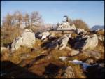
 | Podljubelj (Lajb) - Dobrča
Dobrča is a 1634-metre mountain located between Begunje and Tržič. From the summit, which has a registration box with a stamp, the view opens onl...
4 h 30 min |
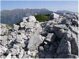
 | Zali Log - Blegoš (via Črni Kal)
Blegoš is a 1,562-metre-high mountain located between the Selška Sora and Poljanska Sora rivers. From the grassy summit, where there is a stamp a...
3 h 30 min |
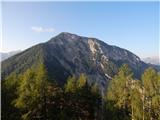
 | Povlje - Bašeljski vrh
Bašeljski vrh is a 1744-meter-high mountain located between Mali Grintovec and Storžič. From the summit, where there is a bench and a registratio...
3 h 50 min |
| Laško - Bašeljski vrh (via Sveti Lovrenc)
Bašeljski vrh is a 1744-meter-high mountain located between Mali Grintovec and Storžič. From the summit, where there is a bench and a registratio...
3 h 40 min |
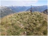
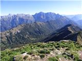
 | Kanonir - Kozji vrh
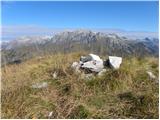
Kozji vrh lies northeast of Storžič and, thanks to its unvegetated summit, offers a beautiful view of all the mountains around Jezersko. Storžič,...
2 h 30 min |
 | Dol - Stegovnik (via Močnikovo sedlo)
Stegovnik (also Štegovnik) is a scenic ridge mountain between the valley of Tržiška Bistrica and Kokra. From the summit, there is a very nice vie...
2 h 30 min |
 | Hotel Plesnik - Strelovec (via Rkljeva peč)
This scenic peak is situated between two Alpine valleys: Logarska dolina and Robanov kot. The view from the summit is most beautiful towards the ...
3 h |
 | Hotel Plesnik - Strelovec (via Plesnikova planina)
This scenic peak is situated between two Alpine valleys: Logarska dolina and Robanov kot. The view from the summit is most beautiful towards the ...
3 h 30 min |
 | Breginj - Muzec - Musc (Mali Muzec)
Muzec or Musc (also Mali Muzec on maps) is a 1,612 m high mountain located north of Breginjski kot. From the summit, where there is a logbook box...
2 h 55 min |
 | Bohinjska Bela (Zgornja vas) - Galetovec (east path (via Iglica))
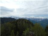
Galetovec is an indistinct peak on the southeastern part of the Pokljuka plateau. From the summit, which has a logbook, there is a nice view of t...
2 h 30 min |
 | Žekovec - Boskovec (via Požganija)
Boskovec is with 1587 m the highest peak of the Golte plateau. From the top on which a lookout tower stands, a view opens up on part of Kamnik Sa...
3 h 15 min |
 | Hotel Plesnik - Logarska peč (via Plesnikova planina)
Logarska peč is a peak or viewpoint a few meters below the summit, rising steeply above the Logarska Valley. From Logarska peč there is a very ni...
2 h 50 min |
 | Predmeja (tunnels) - Veliki Rob (Srednječavenska pot)
Veliki Rob is a panoramic peak situated between Kuclj (1237 m) and Čaven (1185 m). From the summit, where there is a cross, there is a nice view ...
3 h |
 | Breginj - Gabrovec (Veliki Muzec)
Gabrovec (also Veliki Muzec on maps) is a 1630-meter-high mountain located northwest of Breginj, Slovenia's westernmost village. From the summit,...
3 h |
 | Bajdiše (Gozdar) / Waidisch (forsthaus) - Matzen
Macna / Matzen is a 1627-meter-high peak located north of Košuta and south of the Drava River. From Macna, there is a fine view of the nearby Obi...
3 h |
 | Breginj - Nizki vrh
Nizki vrh is located at the crossroads between Breški Jalovec / Monte Maggiore (ITA) and Gabrovec near the state border; from the summit a beauti...
3 h |
 | Bajdiše / Waidisch - Borovski vrh (Žehtar) / Sechter
Borovski vrh (Žehtar) / Sechter is a 1,449-meter-high peak located between Grlovec / Ferlacher Horn and Borovlje / Ferlach. From the summit, wher...
3 h |
 | Prezid (at Gračac) - Crnopac
Crnopac is a panoramic peak at the end of South Velebit. It is located above the settlement of Gračac. The summit area is very rocky. From the to...
2 h 30 min |
 | Gornje Sitno - Ljubljan (via Klančac)
Ljubljan is one of the peaks on Mosor. The summit is an HPO point. Due to long approaches and karst terrain, the peak is rarely visited. From the...
3 h 30 min |
 | Gornje Sitno - Javorska (via Klančac)
Javorska is a lesser-known peak rising to 1,270 meters on the Mosor ridge. It lies along the marked trail between Ljubljan and Vickov stup. From ...
4 h 15 min |
 | Gornje Sitno - Vickov stup (via Ljuvač and past Kabal)
Vickov stup is a red decagonal tower located on a minor summit on Mosor, west of Ljubirna. Inside the tower are benches and a logbook. In bad wea...
3 h 30 min |
 | Gornje Sitno - Ljubirna (via Ljuvač and past Kabal)
Ljubirna is the second-highest peak on Mosor. It lies east of Vickov stup. A concrete pillar at the summit bears the peak's name and elevation. T...
3 h 25 min |
 | Gornje Sitno - Veliki Kabal (via Ljuvač)
Veliki Kabal is the highest peak of Mosor. It lies between Ljubirno and Velim. The summit features a large cross and a summit register with two s...
3 h |
 | Passo Tanamea - Monte Zajavor
Zajavor (Italian: Monte Zajavor or Monte Zaiavor) is a 1,815-meter-high peak in the eastern, grassier part of the Muzci ridge. From the summit, w...
3 h |