 | Selo pri Vodicah - Rašica (Vrh Staneta Kosca) (by road)
Vrh Staneta Kosca, better known as Rašica, is located north of Ljubljana, more precisely above the villages of Rašica and Dobeno. From the summit...
1 h 20 min |
 | Zaplana (Prezid) - Koča na Planini nad Vrhniko
Planina nad Vrhniko is for Vrhnika locals something like Šmarna gora for those from Ljubljana. It is 733 m high, reachable by several paths from ...
1 h 40 min |
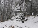
 | Dolenja vas (Kosmulj) - Ključ
Ključ is a forest-covered peak located north of the village Brezje pri Dobrovi and south of Dolenja vas. The summit, which has a stamp box with l...
1 h 10 min |
 | Krnice - Dom v Gorah
The Dom v Gorah mountain hut is located east of Hrastnik, just a few meters below the 786 m high peak where the church of St. Jurij stands. From ...
1 h 5 min |
 | Blečji vrh - Gradišče (via Kucelj)
Gradišče is a lesser-known peak situated north of Višnja gora. From the summit, where a large cross stands, there is a nice view of the surroundi...
1 h 30 min |
 | Mala Goričica - Obolno
Obolno is a 776-meter-high peak located southwest of the eponymous village. From the grassy summit, by which a radio club hut stands, there is a ...
1 h 10 min |
| Mala Goričica - Obolno (by road)
Obolno is a 776-meter-high peak located southwest of the eponymous village. From the grassy summit, by which a radio club hut stands, there is a ...
1 h 15 min |
 | Zgornja Slivnica - Pugled
Pugled is a 615-meter-high peak situated between Podlipoglav and Veliki Lipoglav. From the summit, where a large NOB monument stands, the view is...
1 h 30 min |
 | Hrpelje - Hrpeljska gora
Hrpeljska gora, also known as Mišja šoga, is a 737-meter-high peak located south of Hrpelje. From its partly vegetated summit, there are beautifu...
1 h 30 min |
 | Povir - Stari tabor
Stari Tabor is a panoramic peak located west of Divača, north of Lokev, and south of the village of Povir. From the summit, which has a stamp and...
1 h 10 min |
 | Povir - Stari tabor (harder path)
Stari Tabor is a panoramic peak located west of Divača, north of Lokev, and south of the village of Povir. From the summit, which has a stamp and...
1 h 15 min |
 | Vilenica - Stari tabor (Vilenica - Stari Tabor - Povir)
Stari Tabor is a panoramic peak located west of Divača, north of Lokev, and south of the village of Povir. From the summit, which has a stamp and...
1 h 40 min |
 | Velike Lašče - Kamen vrh
Kamen Vrh is a panoramic hill located on the northern edge of Mala Gora. From the summit, surrounded by low bushes, there are fine views of parts...
1 h 15 min |
 | Mekinje nad Stično - Pristava above Stična
Pristava nad Stično is a small village on a scenic rise north of Stična. Slightly above the village near the Partizanski dom lies a broad, panora...
1 h 5 min |
 | Mekinje nad Stično - Sveti Lambert
Sveti Lambert is located on an inconspicuous rise near the village of Pristava nad Stično. From the summit, once the site of a castle where Duche...
1 h 5 min |
 | Polhov Gradec - Visoki hrib
Visoki hrib is a 602-meter-high hill located south of Polhov Gradec. From the summit, which is partly overgrown with forest, a beautiful view ope...
1 h 15 min |
 | Ljubljanica - Sveti Andrej (Planina above Horjul)
The Church of St. Andrew stands on a panoramic hill just above Planina nad Horjulom. From the church, built in 1659, there is a beautiful view of...
1 h 15 min |
 | Pivka - Šilentabor
Šilentabor is a 751-meter-high peak just above the village of the same name. From the summit, near which there is a bench and a logbook box, ther...
1 h 30 min |
 | Ortnek - Sveti Gregor on Slemena
Sveti Gregor is a settlement on the panoramic Slemena. At its center stands the parish church of St. Gregory the Great, nearby a large sports fie...
1 h 10 min |
 | Gaber pri Semiču - Smuk (via Semenič)
Smuk is a 545-meter-high peak above Semič. The summit features the Church of St. Lawrence, a hunting cabin, and nearby ruins of Smuk (or Turn) Ca...
1 h 10 min |
 | Šahovec - Trebni vrh (Baragova pot)
Trebni vrh is a 581-meter-high hill located south or southwest of Trebnje. On the forested summit stands a bench, and nearby is a logbook box wit...
1 h 5 min |
 | Brezje pri Dobrovi - Vrh (Debeli hrib) (via Strmca)
Vrh is a 540-meter-high hill on the Debeli hrib ridge, which lies between the Ljubljana Marshes and the Horjulščica river valley. The view from t...
1 h 15 min |
 | Treskavac - Obzova
Obzova is the highest point on the island of Krk. Like the entire surrounding area, the summit is completely rocky. Interesting are the pools nea...
1 h 30 min |
 | Žička kartuzija - Babček (via crossing Podgranček)
Babček is an indistinct peak on the hiking trail between Konjiška gora and Boč. An asphalt road runs practically right below the summit. There ar...
1 h 10 min |
 | Žička kartuzija - Babček
Babček is an indistinct peak on the hiking trail between Konjiška gora and Boč. An asphalt road runs practically right below the summit. There ar...
1 h 10 min |
 | Travnarjev gozd (Hotenjsko podolje) - Šenčurjev vrh
Šenčurjev vrh is a 725-meter-high hill located above the settlement of Žibrše, which lies between Logatec, Hotedršica, and Rovte. At the summit, ...
1 h 50 min |
 | Velesovo - Apnišče (via Šterna)
Apnišče is a 740 m high mountain between Možjanca and Štefanja gora. It is the highest point of the Šenčur municipality. The forested summit offe...
1 h 10 min |
 | Okrog (Lazar) - Zaplaz
Zaplaz is a 543-meter-high hill located above Čatež, a settlement best known as the endpoint of the Levstik Trail (From Litija to Čatež). The sum...
1 h 10 min |
 | Radovljica - Lipnica Castle (Pusti grad above Lipnica) (on natural learning trail)
Lipniški Castle, or Pusti grad above Lipnica (German: Waldenberg), is located on a panoramic hill above the Sava and Lipnica watercourses, more p...
1 h 20 min |
 | Višnja Gora - Sveti Duh (Polževo)
The Church of the Holy Spirit is located at 630 meters above sea level on a hill above Hotel Polževo. The stamp is a few dozen meters away, along...
1 h 30 min |
 | Založe (Hotunjščica) - Sevčnik (Andraška pot (pri Vodostečni))
Sevčnik is a hill located northeast of Polzela along the PolzelaVelenje road. The nearest larger settlement is Andraž nad Polzelo. The summit off...
1 h 30 min |
 | Oplotnica - Brinjeva gora (above Zreče) (above quarry)
Brinjeva gora is a prominent hill situated between Zreče and Oplotnica. It is known for several churches located along its entire ridge. Several ...
1 h 30 min |
 | Oplotnica - Brinjeva gora (above Zreče) (on forest path)
Brinjeva gora is a prominent hill situated between Zreče and Oplotnica. It is known for several churches located along its entire ridge. Several ...
1 h 30 min |
 | Puštal (Na Dobravi) - Sveti Andrej (above Zminec)
The Church of St. Andrew is located on a panoramic hill in the Sveti Andrej settlement. From the church, there is a fine view of the Škofjeloško ...
1 h 15 min |
 | Ljubnica - Golek (spodnja pot)
Golek is a 769-meter-high peak located northwest of Zreče. The summit has a logbook box with book and stamp, plus a bench; a short distance (a fe...
1 h 15 min |
 | Bad Gleichenberg (Eichgraben Weg) - Gleichenberger Kogel (via Mühlsteinbruch)
Gleichenberger Kogel is a 598-meter-high mountain of volcanic origin located above Bad Gleichenberg in Styria....
1 h 10 min |
| Bad Gleichenberg (Eichgraben Weg) - Gleichenberger Kogel
Gleichenberger Kogel is a 598-meter-high mountain of volcanic origin located above Bad Gleichenberg in Styria....
1 h 5 min |
| Bad Gleichenberg (Eichgraben Weg) - Gleichenberger Kogel (via Steinriegel)
Gleichenberger Kogel is a 598-meter-high mountain of volcanic origin located above Bad Gleichenberg in Styria....
1 h 55 min |
 | Bad Gleichenberg (Eichgraben Weg) - Bschaidkogel (via Steinriegel)
Bschaidkogel is a 563-meter-high mountain located northeast of the town of Bad Gleichenberg....
1 h 30 min |
 | Gorjane (Železno) - Rigelj
Rigelj is a 626-meter-high indistinct peak in the Orlice range, on which a few antennas stand....
1 h 20 min |