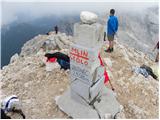
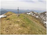
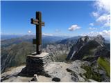
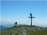
 | Planina Blato - Kanjavec (Za Kopico)
Kanjavec is a 2,569-meter-high mountain located between Dolič and Hribarice. From the summit, which has a logbook box and a stamp, a beautiful vi...
5 h 35 min |
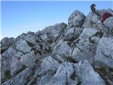
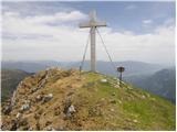
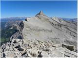
 | V Koncu - Grintovec (via Streha)
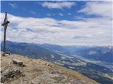
Grintovec is the highest peak of the Kamnik-Savinja Alps. It is located above the Kamniška Bistrica Valley, Suhi Dol, and the Ravenska Kočna Vall...
4 h 30 min |
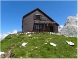
 | The Krma Valley - Triglavski dom na Kredarici
The Triglav Hut at Kredarica is the highest-lying serviced Slovenian mountain hut. It is open all year round but outside the season only on an em...
5 h |
 | Dolina Krma - Begunjski vrh
Begunjski Vrh is a 2,461 m high mountain located in the heart of the highest peaks of the Julian Alps. From the summit, which has a registration ...
5 h 45 min |
 | Ljubelj - Hochstuhl/Stol (lower path)
Stol is, at 2,236 m, the highest peak in the Karawanks. From the summit, which has a registration box and stamp, a beautiful view opens onto the ...
4 h 50 min |
 | Tinčkova koča - Hochstuhl/Stol (via Smokuška planina)
Stol is, at 2,236 m, the highest peak in the Karawanks. From the summit, which has a registration box and stamp, a beautiful view opens onto the ...
4 h 15 min |
 | Dom Trilobit - Hochstuhl/Stol (via Rida (Medji dol))
Stol is, at 2,236 m, the highest peak in the Karawanks. From the summit, which has a registration box and stamp, a beautiful view opens onto the ...
4 h 30 min |
| Tolminske Ravne - Tolminski Kuk (via Planina Kal)
Tolminski Kuk is the highest peak in the Bohinj-Tolmin mountains. The summit, equipped with a registration box, offers a very beautiful view. Fro...
4 h |
 | Planina Blato - Zasavska koča na Prehodavcih (via Prodi)
The Zasavska koča na Prehodavcih mountain hut is located on a panoramic rise above the Valley of the Triglav Lakes. From the hut, open in the sum...
5 h 15 min |
 | Planina Blato - Zasavska koča na Prehodavcih (Za Kopico)
The Zasavska koča na Prehodavcih mountain hut is located on a panoramic rise above the Valley of the Triglav Lakes. From the hut, open in the sum...
5 h 5 min |
 | Planina Jezerca - Kalški greben (via planina Koren)
Kalški greben is a 2224 m high peak and the highest point of the ridge bearing the same name. From the summit, where there is a summit register a...
4 h |
| Markova raven - Kalški greben (on marked path)
Kalški greben is a 2224 m high peak and the highest point of the ridge bearing the same name. From the summit, where there is a summit register a...
4 h 30 min |
 | The Krma Valley - Visoka Vrbanova špica
Visoka Vrbanova špica is located at the far southwestern end of the ridge rising above the Kot and Vrata valleys, and higher up between the Kot a...
5 h 35 min |
 | Planina Kuhinja - Batognica (via jezero v Lužnici)
Batognica is a 2164 m high mountain that was the site of the so-called mine warfare during World War I. Remnants of the fighting between Italian ...
4 h |
| Krn - Batognica (via planina Sleme)
Batognica is a 2164 m high mountain that was the site of the so-called mine warfare during World War I. Remnants of the fighting between Italian ...
4 h 40 min |
 | Koprein-Petzen - Petzen (Kordeschkopf) (Peca (Kordeževa glava))
Kordeževa glava, better known as Peca, is the highest peak of the Peca range. It is located on the border with Austria above the Mežiška dolina v...
4 h |
 | Podpeca (Mitnek) - Petzen (Kordeschkopf) (Peca (Kordeževa glava)) (easy path)
Kordeževa glava, better known as Peca, is the highest peak of the Peca range. It is located on the border with Austria above the Mežiška dolina v...
4 h 15 min |
 | Koča na Pikovem - Petzen (Kordeschkopf) (Peca (Kordeževa glava)) (via saddle Vrh šteng and on easy path)
Kordeževa glava, better known as Peca, is the highest peak of the Peca range. It is located on the border with Austria above the Mežiška dolina v...
4 h 15 min |
 | Hermsberg - Dobratsch / Dobrač
Dobrač, or in German Dobratsch and also known as Villacher Alpen, is a 2166-meter-high mountain situated on the far eastern edge of the Gailtal A...
4 h |
| Bleiberg Kreuth (Wurzach) - Dobratsch / Dobrač
Dobrač, or in German Dobratsch and also known as Villacher Alpen, is a 2166-meter-high mountain situated on the far eastern edge of the Gailtal A...
4 h |
 | Koglereck - Großer Speikkogel (Koralpe)
Großer Speikkogel is, at 2,140 meters, the highest peak of Golica/Koralpe, a range east of Volšperk/Wolfsberg. From the summit, where a cross and...
6 h |
| St. Vinzenz (St. Vinzenz) - Großer Speikkogel (Koralpe)
Großer Speikkogel is, at 2,140 meters, the highest peak of Golica/Koralpe, a range east of Volšperk/Wolfsberg. From the summit, where a cross and...
5 h 40 min |
 | Oberfresen (Brendlwald) - Großer Speikkogel (Koralpe) (lower path)
Großer Speikkogel is, at 2,140 meters, the highest peak of Golica/Koralpe, a range east of Volšperk/Wolfsberg. From the summit, where a cross and...
4 h 15 min |
 | Weissensee - Latschur (via Almspitz)
Latschur (2,236 m) is the highest peak in the eponymous mountain group. From the summit, which features a cross and a summit logbook box, there i...
4 h 15 min |
 | Weissensee - Almspitz (via Techendorfer Alm)
Almspitz (2,180 m) is a peak in the Latschur group. From its grassy summit, there are beautiful views of the Gailtal Alps, Carnic Alps, Julian Al...
4 h |
 | Weissensee - Eckwand (via Karalm)
Eckwand (2,221 m) is a peak in the Latschur group. From its grassy summit, which features a cross, there are beautiful views of the Gailtal Alps,...
5 h |
 | Weissensee - Hochstaff (via Karalm)
Hochstaff (2,217 m) is a peak in the Latschur group. From its grassy summit, which features a cross, there are beautiful views of the nearby Gold...
5 h |
 | Dösner Alm - Säuleck
Säuleck is a 3,086-meter peak in the High Tauern. The summit features a cross and summit register box, providing nice views of nearby peaks such ...
5 h 30 min |
 | Piano Fiscalino / Fischleinboden - Croda Fiscalina di Mezzo / Oberbachernspitze
Croda Fiscalina di Mezzo, or in German Oberbachernspitze, is a 2675-meter-high mountain located in the heart of the Dolomiti di Sesto / Sextner D...
4 h |
 | Bad Kleinkirchheim - Wöllaner Nock (by road)
Wöllaner Nock is a 2145 m high peak located south of the ski area and the settlement Bad Kleinkirchheim. From the spacious summit, where a larger...
4 h 15 min |
 | Erschbaum - Pfannspitze / Cima Vanscuro
Pfannspitze / Cima Vanscuro is a 2,678-meter mountain in the western Carnic Alps. From its cross-topped summit, there are excellent views of the ...
4 h 45 min |
 | Rifugio Pederü - L'Ciaval / Kreuzkofel (path 12)
L'Ciaval / Kreuzkofel is a 2,907-meter-high mountain in the Lavarella group. The mountain and the entire ridge it's located in are recognizable b...
4 h 45 min |
| Rifugio Pederü - L'Ciaval / Kreuzkofel (path 7)
L'Ciaval / Kreuzkofel is a 2,907-meter-high mountain in the Lavarella group. The mountain and the entire ridge it's located in are recognizable b...
4 h 50 min |
 | Stary Smokovec - Slavkovsky štit
Slavkovsky štit is the fourth-highest peak in the High Tatras, standing at 2,452 meters. It is located south of the Velká Studená dolina valley a...
4 h 10 min |
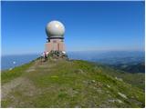
 | Dolina Krma - Kredarica
Kredarica is a 2,541-meter-high panoramic peak located between Triglav and Rž. From the summit, a nice view opens up towards Triglav and the surr...
5 h 5 min |
 | Turrach - Eisenhut
Eisenhut, at 2,441 meters, is the highest peak in the Gurktal Alps, which stretch across the basin of the Krka/Gurk River and descend to the nort...
4 h 30 min |
| Turrach - Eisenhut (via Straßburger Spitz)
Eisenhut, at 2,441 meters, is the highest peak in the Gurktal Alps, which stretch across the basin of the Krka/Gurk River and descend to the nort...
5 h |
 | Turrach - Straßburger Spitz
Straßburger Spitz is a 2,404-meter-high peak located between the summits of Eisenhut (2,441 m) and Wintertalernock (2,394 m). From the top, where...
4 h |
 | Turrach - Wintertalernock
Wintertalernock is a 2,394-meter-high peak located southeast of the highest summit of the Gurktal Alps, Eisenhut. From the top, where a cross sta...
4 h 15 min |
 | Gozdec - Vrh Osojnic
Vrh Osojnic is a 2,371-meter-high peak located between the Dom Petra Skalarja hut on Kanin and Hudi Vršič. From the summit, where a cairn stands,...
4 h 40 min |
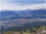 | Hungerberg (parking lot at the station of funicular) - Hafelekarspitze (from Hungerberg on path 216)
Hafelekarspitze is Innsbruck's local mountain and the most popular peak in one of the most admired ridges of the eastern Alps: Nordkette, which f...
4 h |
 | Bottom cable car station Patscherkofelbahn - Patscherkofel (path 350 via Lanser Alm and Zirbenweg)
Patscherkofel is a broad and panoramic mountain rising above Innsbruck, the capital of the Austrian state of Tyrol. It is one of the most popular...
4 h |
 | Masna Luka - Veliki Vilinac (past Pločno and hut Vilinac)
Veliki Vilinac is one of the peaks of the Čvrsnica mountain range, located west of Jablanica in Blidinje Nature Park. Čvrsnica is bounded by the ...
6 h 45 min |
 | Losenheim (Parkplatz am Schneeberg) - Klosterwappen (Schneeberg) (via Schauerstein)
Schneeberg, with its peaks Kaiserstein (2061 m) and Klosterwappen (2076 m), is the easternmost and at the same time the northernmost two-thousand...
4 h 15 min |
 | Losenheim (Parkplatz am Schneeberg) - Klosterwappen (Schneeberg) (past Witzanikreuz)
Schneeberg, with its peaks Kaiserstein (2061 m) and Klosterwappen (2076 m), is the easternmost and at the same time the northernmost two-thousand...
4 h 35 min |
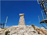
 | Nida - Timios Stavros / Psiloritis (Kreta)
Timios Stavros is Crete's highest mountain at 2,456 meters and also the highest among the Greek islands. Due to its topographic prominence, it is...
4 h 15 min |
 | Seetal - Hochschwab
Hochschwab, at 2,277 meters, is the highest peak of its namesake mountain group in the Northern Limestone Alps. From the summit, where a cross st...
5 h |
| Seetal - Hochschwab (past Schiestelhaus)
Hochschwab, at 2,277 meters, is the highest peak of its namesake mountain group in the Northern Limestone Alps. From the summit, where a cross st...
5 h 5 min |
 | Agion Pneuma (Avrakondes) - Spathi (Crete)
Spathi (Gr. Σπαθί) is at 2,148 m the highest mountain of the Dikti massif (Gr. Δικτή) on the Greek island of Crete. Among Crete's three massifs w...
4 h |
 | Masna Luka - Pločno
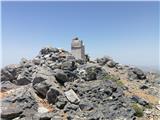
Pločno is the highest peak of the Čvrsnica range and the fourth highest peak in Bosnia and Herzegovina. At its highest point is a geodetic pillar...
4 h 30 min |