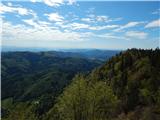
 | Volaka - Blegoš (on unmarked path)
Blegoš is a 1,562-metre-high mountain located between the Selška Sora and Poljanska Sora rivers. From the grassy summit, where there is a stamp a...
2 h 35 min |
 | Potoče - Javorov vrh (via Sveti Jakob, below Potoška gora and over Baba)
Javorov Vrh (recorded in some sources as Javorjev Vrh) is a 1,434 m high mountain northeast of Preddvor. The summit, with its registration box an...
2 h 55 min |
| Spodnja Kokra - Javorov vrh (via Baba)
Javorov Vrh (recorded in some sources as Javorjev Vrh) is a 1,434 m high mountain northeast of Preddvor. The summit, with its registration box an...
2 h 30 min |
 | Klemenčevo - Kamniški vrh (by Korošaki waterfalls)
Kamniški vrh is a 1259-metre-high mountain located north of Kamnik, more precisely between Stahovica and the Korošica valley. From the summit, wh...
2 h 15 min |
 | Klemenčevo - Kamniški vrh (on southwest slope)
Kamniški vrh is a 1259-metre-high mountain located north of Kamnik, more precisely between Stahovica and the Korošica valley. From the summit, wh...
1 h 45 min |
 | Iverje - Kamniški vrh (via Hudi Konci)
Kamniški vrh is a 1259-metre-high mountain located north of Kamnik, more precisely between Stahovica and the Korošica valley. From the summit, wh...
2 h 15 min |
 | Razdrto - Vojkova koča na Nanosu (Janez's path)
Vojkova koča is located on the southern edge of the high karst Nanos plateau, near Pleša. This is the prominent peak with television transmitters...
2 h |
 | Brda - Velika Kopa
Velika Kopa is a 1542-meter-high peak located between Grmovškov dom and the nearby Mala Kopa. From the top, which is only 1 meter lower than the ...
3 h |
 | Selski most - Babji zob
Babji zob is a viewpoint above the village of Kupljenik near Bled. The precipitous peak, which has a registration box, offers a beautiful view of...
2 h 30 min |
 | Bohinjska Bistrica - Krevl (on ski track)
Krevl is a 1515-meter-high peak situated south of the Kobla ski area, more precisely between the Kobla peak and Kravja Črna gora. From the summit...
2 h 45 min |
 | Vitovlje - Čaven
Čaven is a forested peak located west of Veliki Rob (1237 m). No marked trail leads to the summit, despite its very well-known name, even though ...
2 h 30 min |
| Vitovlje - Čaven (via Vitovlje Lake)
Čaven is a forested peak located west of Veliki Rob (1237 m). No marked trail leads to the summit, despite its very well-known name, even though ...
2 h 40 min |
 | Jesenice (Ukova) - Španov vrh
Španov vrh is a 1334-meter-high mountain in the Karavanke that rises between Javorniški Rovt and Planina pod Golico. From the scenic summit, acce...
2 h |
 | Jesenice (Straža) - Španov vrh (via Jelenkamen)
Španov vrh is a 1334-meter-high mountain in the Karavanke that rises between Javorniški Rovt and Planina pod Golico. From the scenic summit, acce...
2 h 30 min |
 | Zalog - Grebenc
Grebenc is a lesser-known peak that rises steeply above Mala and Velika Poljana. From this little-visited summit, on a clear day there is a nice ...
2 h 25 min |
 | Potoče - Baba (via sv. Jakob and source below Potoška gora)
Baba is a 1,119-meter-high peak located west of the Dom Čemšenik mountain hut. The summit, which has a logbook box, offers fine views of the Gore...
2 h 10 min |
 | Radlje ob Dravi - Kapunar / Kapunerkogel (on unmarked path)
Kapunar is a 1,051-meter-high peak above Radlje ob Dravi. Just below the summit stands an old customs post and border guardhouse, now used by ama...
2 h 15 min |
 | Vitanje - Stenica (via valley of the stream Jez)
Stenica is a 1091-meter-high peak located between Vitanje, Stranice, and Frankolovo. The summit, which features a stamp, logbook, and bench with ...
1 h 50 min |
 | Loke - Javor
Javor is a 1,132-meter-high peak situated between Kisovec and Sveta Planina. The summit, covered with forest, offers no views, but a nice panoram...
2 h 25 min |
 | Bled (Velika Zaka) - Hotunjski vrh
Hotunjski vrh is a 1,107-meter-high panoramic peak located above the Zatrnik ski slope. From the summit, where there is a summit register box and...
2 h 30 min |
| Bohinjska Bela (St. Marjeta) - Hotunjski vrh
Hotunjski vrh is a 1,107-meter-high panoramic peak located above the Zatrnik ski slope. From the summit, where there is a summit register box and...
2 h 15 min |
 | Bled (Velika Zaka) - Turn (above Bohinjska Bela)
Turn is a panoramic and precipitous peak located above Bohinjska Bela. From the summit, there is a nice view of Ratitovec, Jelovica, the Kamnik-S...
3 h 15 min |
 | Rebrca / Rechberg - Stara gora / Altberg (via Bukovnik)
Stara gora is a 1,552-meter-high peak located northeast of Ojstrca, the highest peak of Obir. On the summit stand a wooden cross and a bench, wit...
2 h 50 min |
| Rebrca / Rechberg - Stara gora / Altberg (via Rokov vrh)
Stara gora is a 1,552-meter-high peak located northeast of Ojstrca, the highest peak of Obir. On the summit stand a wooden cross and a bench, wit...
3 h 10 min |
 | Njivica - Bela peč (Podbliška gora)
Bela peč is situated on the edge of Jelovica above the village Podblica. From the top of the cliff a beautiful view opens up towards the mentione...
2 h 35 min |
| Nemilje - Bela peč (Podbliška gora) (via Sleme)
Bela peč is situated on the edge of Jelovica above the village Podblica. From the top of the cliff a beautiful view opens up towards the mentione...
2 h 25 min |
 | Kropa (Slovenska peč) - Bela peč (Podbliška gora) (via tehnika Meta)
Bela peč is situated on the edge of Jelovica above the village Podblica. From the top of the cliff a beautiful view opens up towards the mentione...
3 h |
| Kropa - Bela peč (Podbliška gora) (via tehnika Meta)
Bela peč is situated on the edge of Jelovica above the village Podblica. From the top of the cliff a beautiful view opens up towards the mentione...
3 h |
 | Leše - Hom (above Prevalje) (via Kot pri Prevaljah)
Hom is a 1,193 m high peak situated between Uršlja gora and Prevalje. On the summit is a register box with logbook, but the view is quite limited...
2 h 40 min |
| Prevalje - Hom (above Prevalje)
Hom is a 1,193 m high peak situated between Uršlja gora and Prevalje. On the summit is a register box with logbook, but the view is quite limited...
3 h |
 | Mežica - Jesenik (Jesenikov vrh) (via saddle Vrh šteng)
Jesenik, also known as Jesenikov vrh, is a 1,199-meter-high forested peak situated between Mežica and Podpeca....
2 h |
 | Mežica - Jesenik (Jesenikov vrh) (via homestead Jesenik)
Jesenik, also known as Jesenikov vrh, is a 1,199-meter-high forested peak situated between Mežica and Podpeca....
2 h 5 min |
 | Mežica - Pikov vrh (via homestead Jesenik)
Pikov vrh is a 1,149-meter-high peak located above Podpeča, more precisely above the Pik homestead, near the Koča na Pikovem mountain hut. On the...
2 h |
| Črna na Koroškem (Mušenik) - Pikov vrh (via Šumahovo sedlo)
Pikov vrh is a 1,149-meter-high peak located above Podpeča, more precisely above the Pik homestead, near the Koča na Pikovem mountain hut. On the...
2 h 25 min |
 | Mežica - Veliki vrh (above Mežiška dolina) (via Pikov vrh)
Veliki vrh is a 1,165-meter-high peak located between Mežica and Črna na Koroškem. On the summit, beside the television transmitters, there is a ...
2 h 40 min |
| Črna na Koroškem (Mušenik) - Veliki vrh (above Mežiška dolina) (via Koča na Pikovem)
Veliki vrh is a 1,165-meter-high peak located between Mežica and Črna na Koroškem. On the summit, beside the television transmitters, there is a ...
2 h 25 min |
 | Mežica - Šumahov vrh (via Pikov and Veliki vrh)
Šumahov vrh is a 1,155-meter-high peak on which a wooden cross stands. From the summit, which descends steeply towards Žerjav, a nice view opens ...
3 h 5 min |
 | Ravne na Koroškem - Pokeržnikov vrh (via Šteharski vrh)
Pokeržnikov vrh is a 1,055-meter-high peak situated above the settlement of Strojna in the Municipality of Ravne na Koroškem. From the summit, wh...
3 h 15 min |
 | Tržič (Čegelše) - Robič (via Zavetišče na Kalu)
Robič is a 1,384-meter-high peak located between the Tržiška Bistrica Valley and the Košuta ridge. From the summit, there is a beautiful view mai...
2 h 55 min |
 | Činžat - Lamprehtov vrh
Lamprehtov vrh is a 1,230-metre peak in the Pohorje Mountains, located northeast of Klopni vrh....
2 h 30 min |
 | Veliko Tinje - Veliki vrh (on Pohorje) (via Sveti Urh)
Veliki vrh is a 1344-meter-high peak located above the RTC Jakec - Trije kralji ski slope. The highest point of the peak is in the forest, but ju...
2 h 55 min |