 | Kranj (Kalvarija) - Šmarjetna gora (partly on footpath)
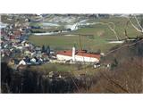
Šmarjetna gora is a panoramic peak rising above Kranj. From the summit, where the Church of St. Margaret and the Hotel Bellevue stand, a beautifu...
40 min |
| Kranj-Stražišče (Šrotenturn) - Šmarjetna gora (east path)
Šmarjetna gora is a panoramic peak rising above Kranj. From the summit, where the Church of St. Margaret and the Hotel Bellevue stand, a beautifu...
45 min |
| Kranj-Stražišče (Šrotenturn) - Šmarjetna gora (by cart track)
Šmarjetna gora is a panoramic peak rising above Kranj. From the summit, where the Church of St. Margaret and the Hotel Bellevue stand, a beautifu...
45 min |
 | Tičnica - Šmarjetna gora
Šmarjetna gora is a panoramic peak rising above Kranj. From the summit, where the Church of St. Margaret and the Hotel Bellevue stand, a beautifu...
50 min |
 | Strmica - Toško Čelo (via Brezarjevo brezno)
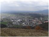
Toško Čelo is a 590-metre hill above the village of the same name. From the summit, or slightly below it, a beautiful view opens over part of Lju...
45 min |
 | Šujica (Na Gmajni) - Toško Čelo (along the stream Ostrožnik)
Toško Čelo is a 590-metre hill above the village of the same name. From the summit, or slightly below it, a beautiful view opens over part of Lju...
55 min |
 | Šujica (Na Gmajni) - Toško Čelo
Toško Čelo is a 590-metre hill above the village of the same name. From the summit, or slightly below it, a beautiful view opens over part of Lju...
50 min |
 | Briše - Mali vrh
West of Polhov Gradec, between the rivers Mala voda and Velika Božna, lies the 708-meter-high hill known as Mali vrh. From the grassy summit, whi...
1 h 5 min |
 | Liboje (quarry) - Kotečnik (via eastern ridge)
Kotečnik is a peak in the Posavsko hribovje, located north of Šmohor. It is a summit with two logboxes: the first on the western subpeak, offerin...
1 h 5 min |
 | Podlipoglav - Pugled (past the guard post)
Pugled is a 615-meter-high peak situated between Podlipoglav and Veliki Lipoglav. From the summit, where a large NOB monument stands, the view is...
50 min |
 | Podlipoglav - Pugled (on the western ridge)
Pugled is a 615-meter-high peak situated between Podlipoglav and Veliki Lipoglav. From the summit, where a large NOB monument stands, the view is...
50 min |
 | Kamnik - Visoka špica (direct way)
An indistinct but clearly visible forested hill above Kamnik from everywhere. Due to the slightly lower Čokl, on which Kamnik Castle stands, it i...
40 min |
 | Kamnik - Visoka špica (via Krniška gora)
An indistinct but clearly visible forested hill above Kamnik from everywhere. Due to the slightly lower Čokl, on which Kamnik Castle stands, it i...
1 h |
 | Kamnik - Visoka špica (via Stari grad)
An indistinct but clearly visible forested hill above Kamnik from everywhere. Due to the slightly lower Čokl, on which Kamnik Castle stands, it i...
50 min |
 | Jasen - Ahac
Ahac (or Sv. Ahac) is a 799-meter-high peak located east of Ilirska Bistrica. The summit hosts a summit logbox, a cross, and ruins of the former ...
1 h |
| Vrbovo - Ahac
Ahac (or Sv. Ahac) is a 799-meter-high peak located east of Ilirska Bistrica. The summit hosts a summit logbox, a cross, and ruins of the former ...
1 h |
 | Grad Hošperk - Stari grad
Stari grad is a 703-meter-high peak between Planina and Unec. From the summit, home to transmitters and obscured by forest and bushes, views are ...
40 min |
 | Činžat - Lobnikov vrh
Lobnikov vrh is a forested peak above the Dravska dolina valley, located between the settlements of Fala and Ruta. From the east, due to its remo...
1 h |
 | Dobrova - Vrhe above Dobrova
Vrhe is a lesser-known but significant peak at the far southeastern end of the Polhograjsko Hribovje. Several unmarked cart tracks and paths lead...
50 min |
 | Hruševo - Vrhe above Dobrova
Vrhe is a lesser-known but significant peak at the far southeastern end of the Polhograjsko Hribovje. Several unmarked cart tracks and paths lead...
1 h |
 | Log - Pečke (by road)
Pečke is an easily accessible peak that has seen fewer visitors lately, located north of the main Pohorje ridge. It gets more visits only on May ...
1 h 5 min |
 | Adergas - Apnišče (via Šterna)
Apnišče is a 740 m high mountain between Možjanca and Štefanja gora. It is the highest point of the Šenčur municipality. The forested summit offe...
1 h |
 | Dvor - Kucelj above Polhov Gradec (on marked path)
Kucelj is a somewhat less known peak located between Polhov Gradec and Dvor pri Polhovem Gradcu. From the 705-meter-high summit, a view opens tow...
1 h |
| Dvor - Kucelj above Polhov Gradec (on unmarked path)
Kucelj is a somewhat less known peak located between Polhov Gradec and Dvor pri Polhovem Gradcu. From the 705-meter-high summit, a view opens tow...
1 h |
| Polhov Gradec - Kucelj above Polhov Gradec (via Ravnek)
Kucelj is a somewhat less known peak located between Polhov Gradec and Dvor pri Polhovem Gradcu. From the 705-meter-high summit, a view opens tow...
1 h |
 | Železniki - Hujska (via Kres)
Hujska is a 706-meter-high peak located above Železniki, more precisely between the Dašnjica and Češnjica streams. At the summit there is a bench...
45 min |
| Železniki - Hujska
Hujska is a 706-meter-high peak located above Železniki, more precisely between the Dašnjica and Češnjica streams. At the summit there is a bench...
40 min |
 | Prevalje - Brinjeva gora (above Prevalje) (via Stations of the Cross)
Brinjeva gora is a popular excursion spot for Prevalje locals, located between the Meža River and Zelenbreški Stream. On the summit stands a smal...
1 h |
| Prevalje - Brinjeva gora (above Prevalje) (south path)
Brinjeva gora is a popular excursion spot for Prevalje locals, located between the Meža River and Zelenbreški Stream. On the summit stands a smal...
1 h |
 | Selca - Lepo brdo
Lepo brdo is a 778-metre hill rising above the Selca and Studeno settlements....
1 h |
 | Sora - Breznik (Boben)
Breznik, also known as Boben, is a 643-meter-high peak situated above the right bank of the Ločnica, more precisely above Sora, Rakovnik, Goričan...
1 h 5 min |
| Rakovnik - Breznik (Boben)
Breznik, also known as Boben, is a 643-meter-high peak situated above the right bank of the Ločnica, more precisely above Sora, Rakovnik, Goričan...
55 min |
 | Prelaz Vrhe - Joški vrh
Joški vrh is a 595-meter-high peak located on the northern side of Donačka gora. A short unmarked path leads to the summit, branching off from th...
1 h 5 min |
| Sveti Jurij - Joški vrh
Joški vrh is a 595-meter-high peak located on the northern side of Donačka gora. A short unmarked path leads to the summit, branching off from th...
1 h 5 min |
 | Stari Grad (Šega) - Dedni vrh (Šuštarica)
Dedni vrh, also known as Šuštarica, is a lesser-known peak in the Karawanks located north of Plešivec. The summit lies in the forest and offers l...
1 h |
 | Ruše - Lorbekov vrh
Lorbekov vrh is a 578-meter-high peak located southwest of Ruše. The summit lies in the forest, but from a meadow just below it, a nice view open...
45 min |
 | Ožbalt (dam on stream Črmenica) - Turška peč (on cart track)
Turška peč is a scenic rocky outcrop above the left bank of the Drava River, along the Ožbalt to Grilov vrh path....
1 h |
 | Želimlje - Sveta Marjeta on Golo (shortest path)
The Church of St. Marjeta sits atop a promontory not far from the village of Golo in the Mokrško hribovje hills south of Ig. Archaeological finds...
40 min |
 | Borovnica - Planina nad Borovnico (Češnjeva pot)
Planina nad Borovnico is a forested peak with no views, featuring a stamp box. The box is located about 20 meters before the 729-meter summit, wh...
55 min |
 | Slovenj Gradec - Rahtelov vrh (eastern path)
Rahtelov vrh is located north of Slovenj Gradec, above the left bank of the Mislinja River. On the summit there is a repeater facility and some t...
45 min |
| Slovenj Gradec - Rahtelov vrh (southeastern path)
Rahtelov vrh is located north of Slovenj Gradec, above the left bank of the Mislinja River. On the summit there is a repeater facility and some t...
45 min |