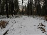
 | Ljubljana (Botanični vrt) - Črni hrib (Golovec)
Črni hrib is a 440 m high hill in the central part of Golovec. The summit, which has a NOB monument and a bench with a table, is crossed by the T...
55 min |
| Ljubljana (Rakovnik) - Črni hrib (Golovec)
Črni hrib is a 440 m high hill in the central part of Golovec. The summit, which has a NOB monument and a bench with a table, is crossed by the T...
50 min |
 | Ljubljana (Štepanja vas) - Črni hrib (Golovec)
Črni hrib is a 440 m high hill in the central part of Golovec. The summit, which has a NOB monument and a bench with a table, is crossed by the T...
50 min |
 | Podgrad - Castle Stari grad (Stari Osterberg) (via millstone quarry)
Stari grad, or Stari Osterberg, was first mentioned in the 12th century (less likely as early as 1015), at which time the castle belonged to the ...
45 min |
 | Podgrad - Murjevka
Murjevka is a 443-meter-high peak above the valley of the Besnica stream, south of Podgrad. The summit is located in the forest so it doesn't off...
40 min |
 | Ljubljana (London) - Mazovnik (Golovec)
Mazovnik, at 450 m, is the highest peak of Golovec, a hill range located on the southeastern outskirts of Ljubljana. Golovec remained bare until ...
35 min |
| Ljubljana (Rakovnik) - Mazovnik (Golovec)
Mazovnik, at 450 m, is the highest peak of Golovec, a hill range located on the southeastern outskirts of Ljubljana. Golovec remained bare until ...
55 min |
 | Podgrad - Lazarjev vrh
Lazarjev vrh is a 452-meter-high peak above the confluence of the Sava, Ljubljanica, and Kamniška Bistrica rivers, east of the Podgrad settlement...
50 min |
 | Suhadole - Koseški hrib (by cart track)
Koseški hrib is located between Kuharjev boršt and Koseze, the settlement after which the peak is also named. From the summit, which has a table,...
40 min |
 | Sveti Lovrenc nad Dragomerom - Strmca (via Vrhovčev grič)
Strmca is a lesser-known forested hill located between the settlements of Brezje pri Dobrovi and Log pri Brezovici. Due to the forest cover, ther...
50 min |
 | Stoperce - Škrbatnica
Škrbatnica is a 473-meter-high hill located above the settlement of Stoperce....
50 min |
 | Zlogonje - Vidikovac Vukovoj
Vidikovac Vukovoj is located on the eastern part of Ravna Gora. Built in 2025, it quickly became extremely popular among visitors and hikers from...
45 min |
 | Brezje pri Dobrovi - Vrhovčev grič (via Strmca)
Vrhovčev grič is an indistinct, forested peak located just a few meters off the marked trail between Debeli hrib and Strmca....
45 min |
 | Ruše - Kluže
Kluže (also Kluža) is a 496-meter-high hill situated between the right bank of the Drava and the left bank of the Lobnica. A short unmarked path ...
45 min |
 | Lake Gradišče - Sveti Mohor on Mohorjev hrib
The church of St. Mohor is situated on a panoramic rise, the lower peak of Mohorjev hrib above Moravče. From the top, a beautiful view opens up t...
50 min |
 | Sveti Mihovil (nad Komižo) - Mali Hum
Mali Hum is located on the island of Vis above the town of Komiža. A cairn marks the summit. Fine views extend to Hum, Komiža, and the nearby isl...
50 min |
 | Hraše - Smledniški hrib (Stari grad)
Stari grad (also known as Smlednik Castle) is located on a small hill southwest of Valburga. In recent years, the castle has been renovated and n...
45 min |
 | Donja Višnjica - Kukelj (direct steep path)
Kukelj is an indistinct summit between the villages of Donja Višnjica, Zlogonje, and Goranec. Rising to 521 meters, it is the highest peak in the...
45 min |
 | Liboje - Kamčič (via organic farm Kralj - northern approach)
Kamčič is a wooded peak in the Posavje Hills, located north of Šmohor between Kotečnik to the left and Veliki Slomnik to the right. It is recogni...
45 min |
 | Podgrad - Debenji vrh (via old castle Osterberg)
Debenji vrh, also known as Debni or Deben vrh, at 530 m, is the highest peak of Kašeljski grič, a small range located between the Besnica valley ...
50 min |
 | Ribnik - Debenji vrh
Debenji vrh, also known as Debni or Deben vrh, at 530 m, is the highest peak of Kašeljski grič, a small range located between the Besnica valley ...
40 min |
 | Temnica - Sveti Ambrož (Tabor) (western path)
Sveti Ambrož (or Tabor) is a hill on the Karst above the villages of Temnica and Lipa. On the summit are the remains of the former St. Ambrož Chu...
45 min |
| Temnica - Sveti Ambrož (Tabor) (northern path)
Sveti Ambrož (or Tabor) is a hill on the Karst above the villages of Temnica and Lipa. On the summit are the remains of the former St. Ambrož Chu...
50 min |
 | Buzet Railway Station - Kuk (above Buzet)
Kuk is a grassy peak above Buzet. It is located on the edge of the cliff above Buzet Railway Station. From the summit, a beautiful view opens up ...
35 min |
 | Dragomer - Vrh (Debeli hrib)
Vrh is a 540-meter-high hill on the Debeli hrib ridge, which lies between the Ljubljana Marshes and the Horjulščica river valley. The view from t...
40 min |
 | Church of St. Lovrenc above Dragomer - Vrh (Debeli hrib) (via Vrhovčev grič)
Vrh is a 540-meter-high hill on the Debeli hrib ridge, which lies between the Ljubljana Marshes and the Horjulščica river valley. The view from t...
45 min |
 | Želimlje - Castle Stari grad above Želimlje
Stari grad above Želimlje is a forest-covered peak located between Želimlje and Rogatec above Želimlje....
50 min |
 | Bad Gleichenberg (Eichgraben Weg) - Bschaidkogel (via Mühlsteinbruch)
Bschaidkogel is a 563-meter-high mountain located northeast of the town of Bad Gleichenberg....
50 min |
 | Povodje - Veliki vrh (Rašica)
Veliki vrh is a 568-meter-high hill located west of Vrh Staneta Kosca. Just a few meters below the otherwise forested summit lies a small abyss n...
45 min |
 | Ruše - Lorbekov vrh
Lorbekov vrh is a 578-meter-high peak located southwest of Ruše. The summit lies in the forest, but from a meadow just below it, a nice view open...
45 min |
 | Strmica - Toško Čelo (via Brezarjevo brezno)
Toško Čelo is a 590-metre hill above the village of the same name. From the summit, or slightly below it, a beautiful view opens over part of Lju...
45 min |
 | Zgornje Poljčane - Baba (at Boč)
Baba is a 594-meter-high forested peak located near two marked paths on Boč, with only two unmarked footpaths leading to the summit....
35 min |
| Zgornje Poljčane - Baba (at Boč) (Detičkova pot)
Baba is a 594-meter-high forested peak located near two marked paths on Boč, with only two unmarked footpaths leading to the summit....
40 min |
 | Vilenica - Stari tabor (past Tupla jama)
Stari Tabor is a panoramic peak located west of Divača, north of Lokev, and south of the village of Povir. From the summit, which has a stamp and...
50 min |
 | Sveta Barbara (Nova Hrastnica) - Sveti Andrej (above Zminec)
The Church of St. Andrew is located on a panoramic hill in the Sveti Andrej settlement. From the church, there is a fine view of the Škofjeloško ...
50 min |
 | Kranj (Kalvarija) - Šmarjetna gora (partly on footpath)
Šmarjetna gora is a panoramic peak rising above Kranj. From the summit, where the Church of St. Margaret and the Hotel Bellevue stand, a beautifu...
40 min |
| Kranj-Stražišče (Šrotenturn) - Šmarjetna gora (east path)
Šmarjetna gora is a panoramic peak rising above Kranj. From the summit, where the Church of St. Margaret and the Hotel Bellevue stand, a beautifu...
45 min |
 | Kranj-Stražišče (Šrotenturn) - Šmarjetna gora (west path)
Šmarjetna gora is a panoramic peak rising above Kranj. From the summit, where the Church of St. Margaret and the Hotel Bellevue stand, a beautifu...
40 min |
| Kranj-Stražišče (Šrotenturn) - Šmarjetna gora (by cart track)
Šmarjetna gora is a panoramic peak rising above Kranj. From the summit, where the Church of St. Margaret and the Hotel Bellevue stand, a beautifu...
45 min |