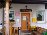
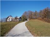
 | Laze pri Dolskem - Janče
Janče is a 792-meter-high peak situated between the Sava River and the Besnica stream valley. From the summit, where a mountain hut stands and th...
2 h 15 min |
 | Litija - Janče (via Širmanski hrib)
Janče is a 792-meter-high peak situated between the Sava River and the Besnica stream valley. From the summit, where a mountain hut stands and th...
3 h 30 min |
 | Kamnica - Sveti Miklavž above Sava (via Velika vas)
The Church of St. Miklavž is situated on a panoramic hill south of Moravče. From the summit, there is a beautiful view toward the nearby Limbarsk...
2 h 5 min |
 | Gračnica - Sveti Lovrenc (above Okroglice) (past Mlinarič)
The Church of St. Lovrenc is located east of Zidani Most and northwest of Sevnica, above the village of Okroglice and near the Lovrenc peak. From...
3 h |
 | Rimske Toplice - Dom v Gorah (via Ogeški potok)
The Dom v Gorah mountain hut is located east of Hrastnik, just a few meters below the 786 m high peak where the church of St. Jurij stands. From ...
2 h 40 min |
| Rimske Toplice (Šmarjeta) - Dom v Gorah (via Lurd)
The Dom v Gorah mountain hut is located east of Hrastnik, just a few meters below the 786 m high peak where the church of St. Jurij stands. From ...
2 h 40 min |
 | Polzela - Gora Oljka (via Vimperk)
Gora Oljka is a hill located east of Šmartno ob Paki. On the summit stands the Church of the Holy Cross, built in the mid-18th century. Just a fe...
2 h 15 min |
 | Laško - Dom na Šmohorju
The mountain hut Dom na Šmohorju is located between Laško, Liboje, and Zabukovica. From the hut, or from the church of St. Mohor just a few minut...
2 h |
 | Gradišče pri Vipavi - Gradiška Tura (via Plaz)
Gradiška Tura is a prominent 754-meter peak rising at the far western edge of the Nanos plateau directly above the Vipava Valley. Thanks to its e...
2 h |
 | Zamedveje - Korada
Korada is a panoramic peak west of the Soča River and on the northern edge of Goriška Brda. From the summit, which has a summit logbox, there is ...
2 h 30 min |
 | Tremerje - Hom above Celje (via crossing Slomnik)
Hom is a forest-covered peak located north of Košnica pri Celju. The summit features a logbook box and a small bench....
2 h 20 min |
 | Štore - Resevna
Resevna is a peak situated south of Šentjur. At the summit stands a 20-meter-high observation tower offering beautiful views that extend far acro...
2 h 30 min |
 | Štore - Resevna (through Bojanski graben and over Resje nad Štorami)
Resevna is a peak situated south of Šentjur. At the summit stands a 20-meter-high observation tower offering beautiful views that extend far acro...
3 h 30 min |
 | Štore - Resevna (via Žlajfa and via Resje nad Štorami)
Resevna is a peak situated south of Šentjur. At the summit stands a 20-meter-high observation tower offering beautiful views that extend far acro...
3 h 15 min |
 | Štore - Tolsti vrh above Celjska koča (via Žlajfa)
Tolsti vrh (also recorded as Tovsti vrh in some sources) is situated above the Celjska koča ski area. The summit has a logbook box and stamp, but...
2 h 15 min |
 | Štore - Tolsti vrh above Celjska koča (via Bojanski graben)
Tolsti vrh (also recorded as Tovsti vrh in some sources) is situated above the Celjska koča ski area. The summit has a logbook box and stamp, but...
2 h 30 min |
 | Štore - Tolsti vrh above Celjska koča (via Marija)
Tolsti vrh (also recorded as Tovsti vrh in some sources) is situated above the Celjska koča ski area. The summit has a logbook box and stamp, but...
2 h |
 | Zvodno - Tolsti vrh above Celjska koča (via Srebotnik on CPP)
Tolsti vrh (also recorded as Tovsti vrh in some sources) is situated above the Celjska koča ski area. The summit has a logbook box and stamp, but...
2 h 15 min |
| Teharje - Tolsti vrh above Celjska koča (via Srebotnik on CPP)
Tolsti vrh (also recorded as Tovsti vrh in some sources) is situated above the Celjska koča ski area. The summit has a logbook box and stamp, but...
3 h |
 | Podsreda - Veliki Špiček (through Osredek pri Podsredi)
Veliki Špiček is the highest peak of Brežice municipality. From the top a nice view spreads towards the south and east. Most of Brežice municipal...
2 h 45 min |
 | Kozjak nad Pesnico - Tojzlov vrh
Tojzlov vrh is a forested hill on the eastern part of Kozjak. On the summit stands a small stone NOB monument and, more recently, also a summit l...
2 h 5 min |
 | Senožeti - Murovica (via Vrh pri Dolskem)
Murovica is a popular excursion point, accessible from the Posavje side, Domžale, or the Moravška Valley. On the summit there is a bench and a lo...
2 h 5 min |
| Senožeti - Murovica (via farm Buven)
Murovica is a popular excursion point, accessible from the Posavje side, Domžale, or the Moravška Valley. On the summit there is a bench and a lo...
1 h 55 min |
 | Laško (cemetery Laško) - Govško brdo
Govško brdo is an 811-meter-high hill located west of the village of Huda Jama above Laško. From the summit, which features a logbook box and sta...
2 h 35 min |
 | Lokvica - Stolovec
Stolovec is a forest-covered peak located west of the better-known Trstelj. The summit has a summit logbox but no stamp....
3 h 15 min |
 | Kozje - Brest (Bohor) (via Vetrnik)
Brest is a peak on Bohor, though it resembles more of a saddle. It is an important trail junction on Bohor, lying between more easterly Oslica an...
2 h |
 | Stari trg (Pilštanj) - Brest (Bohor)
Brest is a peak on Bohor, though it resembles more of a saddle. It is an important trail junction on Bohor, lying between more easterly Oslica an...
2 h 45 min |
 | Štore - Veliki vrh above Svetina (via Marija and over Svetina)
Veliki vrh lies southwest of the settlement of Svetina above Štore. It is settled high up mainly from the south side, with one homestead directly...
2 h 30 min |
 | Štore - Veliki vrh above Svetina (via Žlajfa and via Svetina)
Veliki vrh lies southwest of the settlement of Svetina above Štore. It is settled high up mainly from the south side, with one homestead directly...
2 h 15 min |
 | Štore - Veliki vrh above Svetina (through Bojanski graben and over Svetina)
Veliki vrh lies southwest of the settlement of Svetina above Štore. It is settled high up mainly from the south side, with one homestead directly...
2 h 30 min |
 | Štore - Resje above Štore (via Resevna)
Resje is a peak located directly along the mountain trail between Resevna to the east and Ramanca or Almin dom above Svetina to the west. It lies...
2 h |
 | Štore - Resje above Štore (via Bojanski graben and via Vrunčev dom)
Resje is a peak located directly along the mountain trail between Resevna to the east and Ramanca or Almin dom above Svetina to the west. It lies...
2 h 45 min |
 | Štore - Resje above Štore (via Žlajfa and via Vrunčev dom)
Resje is a peak located directly along the mountain trail between Resevna to the east and Ramanca or Almin dom above Svetina to the west. It lies...
2 h 30 min |
 | Štore - Resje above Štore (via Kompole and Šentjanž)
Resje is a peak located directly along the mountain trail between Resevna to the east and Ramanca or Almin dom above Svetina to the west. It lies...
2 h 45 min |
 | Ponikva/Hotunje - Babček (via Sveta Uršula)
Babček is an indistinct peak on the hiking trail between Konjiška gora and Boč. An asphalt road runs practically right below the summit. There ar...
2 h 45 min |
 | Gorica pri Slivnici - Žusem (Panoramska pot)
Žusem is a 669-meter-high hill with a rich history and great potential for the future. It forms the northern edge of Kozjansko, and its name deri...
3 h 20 min |
 | Maribor - Petnikov vrh (on path over Kozjak)
Petnikov vrh is located northwest of the center of the settlement Gaj nad Mariborom. Next to Gora peak, Petnikov vrh is the closest summit in the...
3 h 30 min |
 | Studenice - Plešivec (at Boč)
Peace, silence, varied terrain... these are characteristics of the peak at the crossroads of numerous paths between the Maribor, Celje, and Ptuj ...
2 h |
 | Studenice - Plešivec (at Boč) (final part on forest road)
Peace, silence, varied terrain... these are characteristics of the peak at the crossroads of numerous paths between the Maribor, Celje, and Ptuj ...
2 h |
 | Rimske Toplice - Vrhe (at Gore) (via Ogeški potok)
Vrhe is a forested 781-meter-high peak located northwest of the Planinski dom hut in Gore....
2 h 50 min |
| Rimske Toplice (Šmarjeta) - Vrhe (at Gore) (via Lurd)
Vrhe is a forested 781-meter-high peak located northwest of the Planinski dom hut in Gore....
2 h 50 min |
 | Slake (Church of the Virgin Mary on Pesek) - Plešivec (Rudnica)
Plešivec is a forest-covered peak on Rudnica, its highest point. The summit has a summit register box, a bench, and a table....
2 h |
| Podčetrtek (Terme Olimia) - Plešivec (Rudnica) (past castle Podčetrtek)
Plešivec is a forest-covered peak on Rudnica, its highest point. The summit has a summit register box, a bench, and a table....
2 h 5 min |
 | Pásztó - Muzsla (path marked with green plus)
Muzsla (Mužlo) is the highest peak in the western part of the Mátra Mountains, which also include Hungary's highest peak Kékestető. A concrete to...
3 h 15 min |
 | Pišece (Pri mlinu) - Veliki vrh (Orlica)
Veliki vrh is the highest point of the Orlica hills at 701 meters above sea level, stretching along the border between Posavje and Kozjansko and ...
2 h 40 min |
 | Podsreda - Intermedija (through Osredek pri Podsredi)
Intermedija is a 662-meter-high peak in the Orlica range. From the summit, there is a beautiful view mainly to the north and northeast, where on ...
2 h 20 min |
 | Čatež ob Savi - Veliki Cirnik
Veliki Cirnik, also known to some locals as Goli Cirnik, is the highest peak in the vicinity of Čatež ob Savi. At the summit, at a spot locals re...
2 h 15 min |
 | Lesično - Bredič
Bredič is a 692-meter-high peak in the ridge of the same name, which rises steeply above the right bank of the Bistrica River between the settlem...
1 h 55 min |