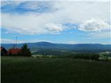
 | Otočec - Sveta Marija (Trška Gora) (via Stari grad)
Trška gora is one of the most famous Slovenian wine hills, where on its southern slope there are the most vineyard cottages in the world and wher...
1 h 15 min |
| Otočec - Sveta Marija (Trška Gora)
Trška gora is one of the most famous Slovenian wine hills, where on its southern slope there are the most vineyard cottages in the world and wher...
1 h |
 | Somlóvásárhely - Somló
Somló is a former volcano located in Veszprém County between the towns of Ajka and Jánosháza. It often goes unnoticed as it stands solitary in th...
45 min |
 | Laško (cemetery Laško) - Church of St. Michael at Šmihel (past Sveti Krištof)
The Church of St. Michael at Šmihel is situated on a scenic hill above Laško. From the church, beautiful views open up to Veliko Kozje, Kopitnik,...
52 min |
 | Kubed - Lačna
Lačna is a 451-meter-high hill located between Gračišče, Kubed, and Hrastovlje. The summit, which features a metal observation tower offering nic...
45 min |
 | Hrastovlje - Lačna
Lačna is a 451-meter-high hill located between Gračišče, Kubed, and Hrastovlje. The summit, which features a metal observation tower offering nic...
1 h 15 min |
 | Radeče - Svinjski rt
Svinjski rt is a panoramic peak located north of Radeče. From the top a beautiful view opens towards the Sava River and Posavje. The logbox is lo...
45 min |
 | Lovska koča Muljava - Veliki Petrovac (Petrova gora) (Roman path)
Veliki Petrovac is a 512-meter-high peak on Petrova gora....
50 min |
 | Štore - Turn (Sveti Janez Krstnik) (via Kompole)
Turn is a peak above Štore - Šentjanž nad Štorami. Slightly below the summit, at the site of the former Prežin Castle, the Church of St. John the...
1 h 15 min |
 | Lovska koča Muljava - Mali Petrovac (Petrova gora) (Roman path)
Mali Petrovac is a rather low hill located somewhere on the border between Banija and Kordun, as well as Pannonian Croatia and Gorski Kotar. The ...
1 h |
 | Hunting cottage Muljava - Mali Petrovac (Petrova gora) (via Mali Velebit)
Mali Petrovac is a rather low hill located somewhere on the border between Banija and Kordun, as well as Pannonian Croatia and Gorski Kotar. The ...
1 h 15 min |
 | Bistrica ob Sotli - Svete gore (E7 path from Bistrica ob Sotli)
Svete gore (527 m) is a hill in the Orlica range, located at the far eastern end of Posavsko hribovje. Its summit, with five church buildings, is...
50 min |
 | Ljubljana (Zalog) - Debenji vrh
Debenji vrh, also known as Debni or Deben vrh, at 530 m, is the highest peak of Kašeljski grič, a small range located between the Besnica valley ...
45 min |
 | Ljubljana (Zalog) - Debenji vrh
Debenji vrh, also known as Debni or Deben vrh, at 530 m, is the highest peak of Kašeljski grič, a small range located between the Besnica valley ...
45 min |
 | Tremerje - Vipota
Vipota is a 532-meter-high peak south of Celje above the left bank of the Savinja River. Approaches to the summit are possible from several direc...
1 h |
 | Zagrad - Vipota
Vipota is a 532-meter-high peak south of Celje above the left bank of the Savinja River. Approaches to the summit are possible from several direc...
1 h |
 | Zagrad - Vipota (via crossing Ivankovič)
Vipota is a 532-meter-high peak south of Celje above the left bank of the Savinja River. Approaches to the summit are possible from several direc...
1 h 15 min |
 | Zbelovo (railway underpass) - Ljubična gora (via Marijine stopinje)
Ljubična gora is an elongated hill above the settlements of Ljubično, Zbelovo and Zbelovska gora. The peak is hidden in forest and not well visib...
45 min |
 | Zbelovo (railway underpass) - Ljubična gora
Ljubična gora is an elongated hill above the settlements of Ljubično, Zbelovo and Zbelovska gora. The peak is hidden in forest and not well visib...
45 min |
 | Zgornje Poljčane - Ljubična gora
Ljubična gora is an elongated hill above the settlements of Ljubično, Zbelovo and Zbelovska gora. The peak is hidden in forest and not well visib...
1 h 15 min |
 | Velika Kostrevnica - Kožljevec
Kožljevec (also Kožlevec) is a 533-meter-high hill above Cerovica in the municipality of Šmartno pri Litiji. The forested summit features a logbo...
1 h 10 min |
 | Naraplje - Church of St. Bolfenk (Jelovice)
The Church of St. Bolfenk is situated on a 537-meter-high hill above the settlement of Jelovice. From the top, a nice view opens up towards Haloz...
1 h |
| Stogovci (Vabča vas) - Church of St. Bolfenk (Jelovice)
The Church of St. Bolfenk is situated on a 537-meter-high hill above the settlement of Jelovice. From the top, a nice view opens up towards Haloz...
1 h |
 | Zagorica pri Dobrniču - Lisec (Liška gora)
Lisec is a 565-meter-high peak located north to northeast of Žužemberk and southwest of Dobrnič. On the summit stands a metal cross with an attac...
1 h |
 | Šentjur - Rifnik
Rifnik is a 568-meter-high peak situated south of Šentjur pri Celju. The summit, known for its archaeological site, offers nice views towards Šen...
45 min |
 | Gorica pri Slivnici - Rifnik
Rifnik is a 568-meter-high peak situated south of Šentjur pri Celju. The summit, known for its archaeological site, offers nice views towards Šen...
1 h 15 min |
| Vezovje (bus station Vezovje most) - Rifnik
Rifnik is a 568-meter-high peak situated south of Šentjur pri Celju. The summit, known for its archaeological site, offers nice views towards Šen...
45 min |
 | Podčetrtek (sveti Lovrenc) - Zavetišče Šmarnica on Mala Rudnica (past castle Podčetrtek)
The Šmarnica shrine is located on Mala Rudnica within the Rudnica range, a smaller hill chain above Podčetrtek. From the shrine there opens a bea...
1 h 5 min |
| Podčetrtek (sveti Lovrenc) - Zavetišče Šmarnica on Mala Rudnica
The Šmarnica shrine is located on Mala Rudnica within the Rudnica range, a smaller hill chain above Podčetrtek. From the shrine there opens a bea...
1 h |
 | Trebnje Castle - Trebni vrh (steep path)
Trebni vrh is a 581-meter-high hill located south or southwest of Trebnje. On the forested summit stands a bench, and nearby is a logbook box wit...
45 min |
| Trebnje Castle - Trebni vrh (via caves)
Trebni vrh is a 581-meter-high hill located south or southwest of Trebnje. On the forested summit stands a bench, and nearby is a logbook box wit...
50 min |
 | Trebnje Castle - Trebni vrh (steep path via hunting cottage)
Trebni vrh is a 581-meter-high hill located south or southwest of Trebnje. On the forested summit stands a bench, and nearby is a logbook box wit...
55 min |
| Trebnje Castle - Trebni vrh (via caves and hunting lodge)
Trebni vrh is a 581-meter-high hill located south or southwest of Trebnje. On the forested summit stands a bench, and nearby is a logbook box wit...
1 h |
 | Stojdraga (Glažuta) - Tuščak (Žumberačka gora)
Tuščak is a forested hill above the Bregana River valley on Žumberačka gora. The summit features a logbox....
1 h 10 min |
 | Tremerje - Veliki Slomnik
Veliki Slomnik is a peak located between Košnica pri Celju and Liboje. The summit has a logbook box, but due to the surrounding forest, there are...
1 h |
 | Bad Gleichenberg (Sägewerk Weiss) - Stradner Kogel
Stradner Kogel is the highest hill in southeastern Styria, Austria. The hill is of volcanic origin, and the summit offers no views in any directi...
1 h 15 min |
| Haag - Stradner Kogel
Stradner Kogel is the highest hill in southeastern Styria, Austria. The hill is of volcanic origin, and the summit offers no views in any directi...
1 h 10 min |