 | Sant'Uberto - Vallon Bianco
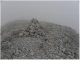
Vallon Bianco (Ladin: Valun Blanch) is a 2,688-meter peak above the Valle di Fanes and Val Travenanzes valleys. From the summit, which has a smal...
5 h 5 min |
| Rifugio Pederü - Vallon Bianco
Vallon Bianco (Ladin: Valun Blanch) is a 2,688-meter peak above the Valle di Fanes and Val Travenanzes valleys. From the summit, which has a smal...
4 h 40 min |
 | Plöckenpass - Creta di Collina / Kollinkofel (path 171)
Creta di Collina (German: Kollinkofel) is a 2,691-meter-high mountain in the Carnic Alps. In the immediate surroundings of the mountain, there ar...
4 h |
 | Plöckenpass - Creta di Collina / Kollinkofel (via Cresta Verde)
Creta di Collina (German: Kollinkofel) is a 2,691-meter-high mountain in the Carnic Alps. In the immediate surroundings of the mountain, there ar...
4 h |
 | Rudno polje - Mali Triglav (via Dom Planika)
Mali Triglav is an indistinct summit on the main ridge of Triglav. Despite its considerable height, it is rarely chosen as an independent objecti...
5 h 50 min |
| Rudno polje - Mali Triglav (via Kredarica)
Mali Triglav is an indistinct summit on the main ridge of Triglav. Despite its considerable height, it is rarely chosen as an independent objecti...
6 h 5 min |
| end of road on Pokljuka - Mali Triglav (via Planika)
Mali Triglav is an indistinct summit on the main ridge of Triglav. Despite its considerable height, it is rarely chosen as an independent objecti...
5 h 25 min |
| end of road on Pokljuka - Mali Triglav (via Kredarica)
Mali Triglav is an indistinct summit on the main ridge of Triglav. Despite its considerable height, it is rarely chosen as an independent objecti...
5 h 40 min |
| Uskovnica (Razpotje) - Mali Triglav (via Planika)
Mali Triglav is an indistinct summit on the main ridge of Triglav. Despite its considerable height, it is rarely chosen as an independent objecti...
5 h 55 min |
 | Prebersee - Roteck
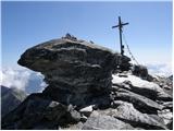
Roteck is a 2742 m high peak located north of Tamsweg in the heart of the Lower Tauern. From the summit, where a cross stands, there is a nice vi...
4 h |
 | Piano Fiscalino / Fischleinboden - Monte Paterno (Ferrata De Luca-Innerkofler)
Monte Paterno is a 2744-meter-high panoramic peak. From the top, there is a breathtaking view in all directions, especially the Tre Cime to the w...
4 h 10 min |
 | Plockenpass - Pilastro del Coglians
Pilastro del Coglians is a 2,750-metre peak east of Monte Coglians on the Austria-Italy border. A summit logbook is located on the compact summit...
4 h 30 min |
| Rifugio Tolazzi - Pilastro del Coglians (via Rifugio Marinelli)
Pilastro del Coglians is a 2,750-metre peak east of Monte Coglians on the Austria-Italy border. A summit logbook is located on the compact summit...
3 h 55 min |
 | Plöckenpass - Creta della Chianevate / Kellerspitzen (path 171)
Creta della Chianevate (German: Kellerspitzen) is a 2,769-meter peak in the central Carnic Alps on the AustriaItaly border. From the summit, mark...
4 h 50 min |
| Plöckenpass - Creta della Chianevate / Kellerspitzen (via Cresta Verde)
Creta della Chianevate (German: Kellerspitzen) is a 2,769-meter peak in the central Carnic Alps on the AustriaItaly border. From the summit, mark...
5 h |
 | Rifugio Pederü - Furcia Rossa III
Furcia Rossa III is a 2,791-meter-high peak in a somewhat more remote ridge along which the Walk of Peace (Fridensweg / Via della Pace) runs. At ...
4 h 50 min |
| Sant'Uberto - Furcia Rossa III
Furcia Rossa III is a 2,791-meter-high peak in a somewhat more remote ridge along which the Walk of Peace (Fridensweg / Via della Pace) runs. At ...
5 h 15 min |
 | Passo di Costalunga / Karerpass - Roda di Vael / Rotwand (Via Ferrata Majare)
Roda di Vael (German: Rotwand) is a 2,806-meter-high mountain in the Catinaccio (Rosengarten) group. The mountain is recognizable mainly by its s...
5 h 30 min |
 | Ristorante Pietofana - Cima Formenton (via Rifugio Pomedes)
Cima Formenton is a 2,830-meter-high peak in the Tofana group. The mountain lies north of the better-known Tofana di Dentro, with an unmarked tra...
5 h 5 min |
 | end of road on Pokljuka - Triglav (via Kredarica)
Triglav is a 2,864 m high mountain located in the heart of the Julian Alps. At this altitude, it is the highest mountain in Slovenia and also the...
6 h 15 min |
| end of road on Pokljuka - Triglav (via Planika and Mali Triglav)
Triglav is a 2,864 m high mountain located in the heart of the Julian Alps. At this altitude, it is the highest mountain in Slovenia and also the...
6 h |
| Uskovnica (Razpotje) - Triglav (via Planika and Mali Triglav)
Triglav is a 2,864 m high mountain located in the heart of the Julian Alps. At this altitude, it is the highest mountain in Slovenia and also the...
6 h 30 min |
 | Uskovnica (Razpotje) - Triglav (via Triglavska škrbina)
Triglav is a 2,864 m high mountain located in the heart of the Julian Alps. At this altitude, it is the highest mountain in Slovenia and also the...
6 h 25 min |
| end of road on Pokljuka - Triglav (via Planika and Triglavska škrbina)
Triglav is a 2,864 m high mountain located in the heart of the Julian Alps. At this altitude, it is the highest mountain in Slovenia and also the...
5 h 55 min |
| Rudno polje - Triglav (via Kredarica)
Triglav is a 2,864 m high mountain located in the heart of the Julian Alps. At this altitude, it is the highest mountain in Slovenia and also the...
6 h 40 min |
| Rudno polje - Triglav (via Dom Planika and Mali Triglav)
Triglav is a 2,864 m high mountain located in the heart of the Julian Alps. At this altitude, it is the highest mountain in Slovenia and also the...
6 h 25 min |
| Rudno polje - Triglav (past Dom Planika and Triglavska škrbina)
Triglav is a 2,864 m high mountain located in the heart of the Julian Alps. At this altitude, it is the highest mountain in Slovenia and also the...
6 h 20 min |
 | Parking Erichhütte - Hoher Kopf (path 432)
Hoher Kopf is located in the Berchtesgaden Alps, west of the highest peak, Höchkonig. The summit is popular mainly due to the protected climbing ...
4 h 45 min |
 | Parkplatz Erichhütte - Hochkönig (path 432)
Hochkönig is, at 2941 meters, the highest peak of the Berchtesgaden Alps. The peak, on which the Matrashaus mountain hut stands, is very well vis...
5 h 20 min |
 | Parkplatz Innerfragant - Alteck (via Fraganter Scharte)
Alteck is a 2,942-meter-high peak rising steeply above Lake Hochwurtenspeicher next to the Mölltaler Gletscher ski slope. From the summit, where ...
7 h |
 | Obermoos - Zugspitze (Stopselziehersteig)
Zugspitze, at 2,962 meters, is the highest peak of the Wetterstein group and also Germany's highest mountain. It lies south of Garmisch-Partenkir...
5 h |
 | Piano Fiscalino / Fischleinboden - Croda Rossa di Sesto (Via Ferrata Croda Rossa)
Croda Rossa di Sesto (German: Sextner Rotwand, also Zehner) is a 2,965-meter-high mountain in the Sexten Dolomites (Dolomiti di Sesto). The mount...
5 h |
 | Rifugio Pederü - Cima Nove / Neunerspitze
The Italian Cima Nove or Sasso delle Nove, German Neuner or Neunerspitze, Ladin Sas dles Nü or Nönör is a 2,968-meter-high peak in the Fanes-Sene...
4 h 50 min |
 | Türlwandhütte - Hoher Dachstein (via Hunerscharte)
Hoher Dachstein is, at 2995 meters, the highest peak of the Dachstein mountain group. The summit is located on the border between the federal sta...
5 h 45 min |
 | Alba di Canazei - Cima Ombretta (Via Ferrata Ombretta)
Cima Ombretta is a 3,011-meter-high peak in the Marmolada mountain group. From the summit, where a cross stands, there is the finest view of the ...
5 h 15 min |
 | Rifugio Pederü - Sasso delle Dieci / Zehnerspitze (path 12)
Sasso delle Dieci / Zehnerspitze is a 3,028-meter-high mountain rising steeply above Val Badia valley. Sasso delle Dieci is the highest peak in t...
5 h 30 min |
| Rifugio Pederü - Sasso delle Dieci / Zehnerspitze (path 7)
Sasso delle Dieci / Zehnerspitze is a 3,028-meter-high mountain rising steeply above Val Badia valley. Sasso delle Dieci is the highest peak in t...
5 h 35 min |
 | Lenzanger - Goldzechkopf (via Hoher Sonnblick)
Goldzechkopf is a 3042-meter-high peak in the Goldberg mountain group. The summit is located on the ridge between the better-known Hoher Sonnblic...
6 h 10 min |
 | Rifugio Pederü - Piz dles Conturines
Piz dles Conturines, at 3064 m, is the highest peak in the Lavarella group. From the cross-topped summit, there are fine views of the entire grou...
6 h 30 min |
 | Malga Fosse - Il Nuvolo
Il Nuvolo is a 3,075-meter-high peak in the Pale di San Martino mountain group. The mountain is located above the Valle dei Cantoni valley, right...
5 h 40 min |
 | Sporthotel Maltatal - Großer Hafner
Großer Hafner, at 3076 m, is the highest peak of the Hafner group. From the summit, where a cross stands, there is a nice view of the mentioned g...
4 h 30 min |
 | Lenzanger - Hoher Sonnblick (via Goldzechkopf)
Hoher Sonnblick, also known as Rauriser Sonnblick, is a 3106-meter-high mountain in the Goldberg group. The Zittelhaus hut and Austria's highest ...
6 h 30 min |
 | Passo Campolongo - Cresta Strenta (Via Ferrata Vallon)
Cresta Strenta is a less prominent peak north of Piz Boè. From the summit there is a superb view over much of the Dolomites. At 3,124 meters, Cre...
4 h 25 min |
 | Passo Campolongo - Piz Boe (Via Ferrata Vallon)
Piz Boe, at 3,152 meters, is the highest peak in the Sella group in the Italian Dolomites. From the summit, there are beautiful views of Marmolad...
4 h 40 min |
 | Malga Fosse - Cima Vezzana (Via Ferrata Bolver Lugli)
Cima di Vezzana is the highest peak in the Pale di San Martino mountain group at 3,192 meters. From the summit there is a very nice view over muc...
4 h 30 min |
| Malga Fosse - Cima Vezzana
Cima di Vezzana is the highest peak in the Pale di San Martino mountain group at 3,192 meters. From the summit there is a very nice view over muc...
6 h 10 min |
 | Seichenbrunn - Glödis
Glödis (or Glödisspitze) is a 3,206-meter-high mountain in the Schober group within Hohe Tauern National Park. The summit, crowned by a large cro...
5 h |
 | Palafavera - Monte Civetta (Via Normale)
Monte Civetta is one of the main mountains in the Dolomites. It is recognizable primarily by its more than 1000-meter-high northwestern wall. Thi...
6 h 20 min |
 | Leibnitzbachbrücke - Hochschober (via Staniskascharte)
Hochschober is a 3,240-meter-high mountain in the Schober group. Although it is the fourth highest in the group, the mountain group is named afte...
5 h |
 | Gschnitz - Habicht (normal path past Innsbrucker Hütte (Gschnitz))
Habicht (Slovenian "kragulj" or goshawk) is a broad and imposing mountain rising high above the Stubai and Obertal valleys. Due to its somewhat i...
5 h 30 min |
| parking lot at guesthouse Feuerstein - Habicht (normal path past Innsbrucker Hütte (Feuerstein))
Habicht (Slovenian "kragulj" or goshawk) is a broad and imposing mountain rising high above the Stubai and Obertal valleys. Due to its somewhat i...
5 h 15 min |
 | Alba di Canazei - Punta Penia (Marmolada)
Punta Penia, at 3,343 meters, is the highest peak of Marmolada and the Italian Dolomites. From the summit, where there is a small mountain hut (s...
6 h 15 min |
 | parking lot before Plangeroß - Hohe Geige (route through western ridge (I-II))
Hohe Geige, at an elevation between 3,393 and 3,396 m, is one of the highest and most important peaks in the northern part of the Ötztal Alps. As...
5 h |