 | Šujica (Na Gmajni) - Toško Čelo (along the stream Ostrožnik)
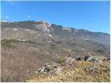
Toško Čelo is a 590-metre hill above the village of the same name. From the summit, or slightly below it, a beautiful view opens over part of Lju...
55 min |
 | Šujica (Na Gmajni) - Toško Čelo
Toško Čelo is a 590-metre hill above the village of the same name. From the summit, or slightly below it, a beautiful view opens over part of Lju...
50 min |
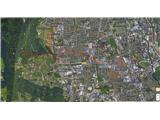
 | Spodnje Pirniče - Grmada (Kovačeva steza)
Grmada is a 676-meter-high mountain located west of the much more visited Šmarna gora. From the summit, which has a small takeoff area, a beautif...
1 h 10 min |
 | Gojače - Školj Svetega Pavla above Vrtovin (via water tower)
Školj sv. Pavla is located on a panoramic hill above the village of Vrtovin, which lies west of Ajdovščina. From the church, near which the logbo...
1 h |
 | Grgar - Vodice (on the route of gas line)
Vodice (according to some records also Sveti Jakob) is a peak on the western part of the Banjška planota plateau. From the summit, which features...
1 h 30 min |
 | Grgar - Vodice (by road)
Vodice (according to some records also Sveti Jakob) is a peak on the western part of the Banjška planota plateau. From the summit, which features...
1 h 15 min |
 | Celje (hanging bridge) - Hom above Celje
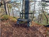
Hom is a forest-covered peak located north of Košnica pri Celju. The summit features a logbook box and a small bench....
1 h |
 | Celje (hanging bridge) - Hom above Celje (via Petriček and Lisce)
Hom is a forest-covered peak located north of Košnica pri Celju. The summit features a logbook box and a small bench....
1 h 10 min |
 | Podgrad - Debenji vrh
Debenji vrh, also known as Debni or Deben vrh, at 530 m, is the highest peak of Kašeljski grič, a small range located between the Besnica valley ...
1 h |
| Podgrad - Debenji vrh (via old castle Osterberg)
Debenji vrh, also known as Debni or Deben vrh, at 530 m, is the highest peak of Kašeljski grič, a small range located between the Besnica valley ...
50 min |
 | Podlipoglav - Pugled (past the guard post)
Pugled is a 615-meter-high peak situated between Podlipoglav and Veliki Lipoglav. From the summit, where a large NOB monument stands, the view is...
50 min |
 | Podlipoglav - Pugled (on the western ridge)
Pugled is a 615-meter-high peak situated between Podlipoglav and Veliki Lipoglav. From the summit, where a large NOB monument stands, the view is...
50 min |
 | Dragomer (OŠ Log-Dragomer) - Strmca (via Strmec)
Strmca is a lesser-known forested hill located between the settlements of Brezje pri Dobrovi and Log pri Brezovici. Due to the forest cover, ther...
1 h 10 min |
 | Dobrova - Vrhe above Dobrova
Vrhe is a lesser-known but significant peak at the far southeastern end of the Polhograjsko Hribovje. Several unmarked cart tracks and paths lead...
50 min |
 | Hruševo - Vrhe above Dobrova
Vrhe is a lesser-known but significant peak at the far southeastern end of the Polhograjsko Hribovje. Several unmarked cart tracks and paths lead...
1 h |
 | Izlake (Medijske toplice) - Vrhija (via Podlipovica)
Vrhija is a 648-meter-high hill located west of Izlake and east of Kolovrat. It lies between Kalanov hrib and Kolovraška reber, viewed from the N...
1 h 15 min |
 | Brezovica pri Ljubljani - Vrh (Debeli hrib)
Vrh is a 540-meter-high hill on the Debeli hrib ridge, which lies between the Ljubljana Marshes and the Horjulščica river valley. The view from t...
1 h |
 | Brezje pri Dobrovi - Vrh (Debeli hrib) (past Strmca)
Vrh is a 540-meter-high hill on the Debeli hrib ridge, which lies between the Ljubljana Marshes and the Horjulščica river valley. The view from t...
1 h 10 min |
 | Želimlje - Castle Stari grad above Želimlje
Stari grad above Želimlje is a forest-covered peak located between Želimlje and Rogatec above Želimlje....
50 min |
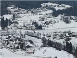
 | Graz Center West - Buchkogel (Rudolfswarte) (via St. Martin)
Buchkogel, also known as Graz Buchkogel, is located west of Graz and, alongside Plabutsch, is one of the most popular excursion destinations on t...
1 h 30 min |
 | Sora - Breznik (Boben)
Breznik, also known as Boben, is a 643-meter-high peak situated above the right bank of the Ločnica, more precisely above Sora, Rakovnik, Goričan...
1 h 5 min |
| Rakovnik - Breznik (Boben)
Breznik, also known as Boben, is a 643-meter-high peak situated above the right bank of the Ločnica, more precisely above Sora, Rakovnik, Goričan...
55 min |
 | Tremerje - Kamčič (on the ridge of Mali Slomnik)
Kamčič is a wooded peak in the Posavje Hills, located north of Šmohor between Kotečnik to the left and Veliki Slomnik to the right. It is recogni...
1 h 15 min |
 | Podgrad - Grmadnik
Grmadnik is a 569-meter-high peak above the valley of the Besnica stream between Podgrad and Besnica. The Borovničeva pohodna pot trail runs just...
55 min |
 | Podgrad - Španov vrh (Besnica)
Španov vrh is a 559-meter-high peak above the Besnica stream valley between Podgrad and Besnica. Just below the summit runs the Borovničeva hikin...
50 min |
 | Naraplje - Kerješetov vrh
Kerješetov vrh is a 590-meter-high hill located above the settlement of Jelovice. The summit is overgrown with forest, so there is no good view f...
1 h 30 min |
 | Sveti Jurij - Joški vrh
Joški vrh is a 595-meter-high peak located on the northern side of Donačka gora. A short unmarked path leads to the summit, branching off from th...
1 h 5 min |
 | Bad Gleichenberg (Eichgraben Weg) - Bschaidkogel (via Mühlsteinbruch)
Bschaidkogel is a 563-meter-high mountain located northeast of the town of Bad Gleichenberg....
50 min |
 | Ožbalt (dam on stream Črmenica) - Turška peč (on cart track)
Turška peč is a scenic rocky outcrop above the left bank of the Drava River, along the Ožbalt to Grilov vrh path....
1 h |
 | Ruše - Globokarjev vrh
Globokarjev vrh is situated on a small ridge between Drava and Lobnica, only a few minutes away from the Globokar farm. Several antennas stand on...
1 h 15 min |
 | Olimje - Lendrše
Lendrše is a 617-meter-high peak on Rudnica from which beautiful views open towards Boč....
1 h 20 min |
 | Olimje - Olimska gora (past lake Zmajevo jezero)
Olimska gora lies above Olimje on Rudnica. Its forested summit offers no scenic views....
1 h 25 min |
 | Zagorje ob Savi - Vinski vrh
Vinski vrh is a 616-meter-high hill, situated between the streams Medija and Kotredeščica, more precisely between the villages Vine and Zavine. T...
1 h |
 | Donja Višnjica - Kukelj (through Goranec)
Kukelj is an indistinct summit between the villages of Donja Višnjica, Zlogonje, and Goranec. Rising to 521 meters, it is the highest peak in the...
1 h 15 min |
 | Marof pri Pišecah - Intermedija (via Velika bukva)
Intermedija is a 662-meter-high peak in the Orlica range. From the summit, there is a beautiful view mainly to the north and northeast, where on ...
1 h 10 min |