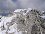
 | Aljažev dom v Vratih - Stenar (via Sovatna)
Stenar is a 2,501-meter-high peak that rises steeply above the Vrata Valley. From the spacious summit, which has a logbook box and a stamp, a bea...
5 h 15 min |
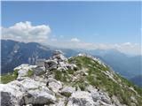
 | Sella Nevea - Prestreljenik (on ski track)
Prestreljenik is a 2,499 m high mountain located in the heart of the Kanin range. From the summit, where there is a registration box shaped like ...
3 h 30 min |
 | Ljubelj - Hochstuhl/Stol (upper way)
Stol is, at 2,236 m, the highest peak in the Karawanks. From the summit, which has a registration box and stamp, a beautiful view opens onto the ...
4 h 50 min |
| Johannsenruhe - Hochstuhl/Stol (via Klagenfurter Hütte)
Stol is, at 2,236 m, the highest peak in the Karawanks. From the summit, which has a registration box and stamp, a beautiful view opens onto the ...
3 h 45 min |
| Ljubelj - Hochstuhl/Stol (via Vatelca or Skleda)
Stol is, at 2,236 m, the highest peak in the Karawanks. From the summit, which has a registration box and stamp, a beautiful view opens onto the ...
5 h |
 | Gozd - Storžič (through southwest groove)
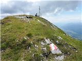
Storžič is a 2132 m high mountain located in the western part of the Kamnik-Savinja Alps. From the summit, where there is a cross, a beautiful vi...
4 h 55 min |
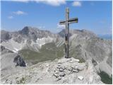
 | Planina Kuhinja - Krn (via jezero v Lužnici)
Krn, at 2244 m, is the highest peak of the Krn mountain group, which rises steeply above the central part of the Soča River. From the summit, fea...
4 h 45 min |
| Krn - Krn (via planina Sleme)
Krn, at 2244 m, is the highest peak of the Krn mountain group, which rises steeply above the central part of the Soča River. From the summit, fea...
5 h 25 min |
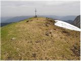
 | Aljažev dom v Vratih - Križ (via bivak na Rušju)
Križ is a 2,140 m high mountain located northeast of the Kriški Podi plateau. The summit, which has a registration box with a stamp, offers a bea...
4 h 30 min |
 | Ljubelj - Prešernova koča na Stolu (upper way)
The Prešernova koča na Stolu mountain hut is located just a few metres below the summit of the 2198 m high Mali Stol. From the hut or the nearby ...
4 h 45 min |
| Ljubelj - Prešernova koča na Stolu (via Vatelca or Skleda)
The Prešernova koča na Stolu mountain hut is located just a few metres below the summit of the 2198 m high Mali Stol. From the hut or the nearby ...
4 h 55 min |
 | Trate / Johannsenruhe - Prešernova koča na Stolu (via Celovška koča)
The Prešernova koča na Stolu mountain hut is located just a few metres below the summit of the 2198 m high Mali Stol. From the hut or the nearby ...
3 h 40 min |
 | Kokra (Roblek) - Kalški greben
Kalški greben is a 2224 m high peak and the highest point of the ridge bearing the same name. From the summit, where there is a summit register a...
3 h 55 min |
 | Velacher Kotschna/Belska Kočna - Ledinski vrh
The mountain is located above Jezersko and lies on the border with Austria. From the summit there is a beautiful view north towards the neighbour...
3 h 45 min |
 | Matizovec - Veliko Kladivo
Veliko Kladivo is a 2094 m high peak in the longest Slovenian ridge, Košuta. From the summit, which has a register box and stamp, there is a very...
3 h 20 min |
| Dolina - Veliko Kladivo
Veliko Kladivo is a 2094 m high peak in the longest Slovenian ridge, Košuta. From the summit, which has a register box and stamp, there is a very...
3 h 30 min |
| Dolina - Veliko Kladivo (past the chapel)
Veliko Kladivo is a 2094 m high peak in the longest Slovenian ridge, Košuta. From the summit, which has a register box and stamp, there is a very...
3 h 30 min |
 | Planina Kuhinja - Batognica
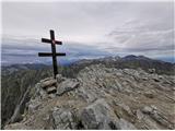
Batognica is a 2164 m high mountain that was the site of the so-called mine warfare during World War I. Remnants of the fighting between Italian ...
3 h 20 min |
| Dom v Lepeni - Batognica (via Krnska škrbina)
Batognica is a 2164 m high mountain that was the site of the so-called mine warfare during World War I. Remnants of the fighting between Italian ...
4 h 50 min |
 | Bele Vode - Jerebica
Jerebica is a mountain located on the border between Slovenia and Italy, between the Možnica and Jezerska valleys. From the summit, where there i...
3 h 30 min |
 | Planina Blato - Mala Zelnarica (Za Kopico)
Mala Zelnarica is a 2310-meter-high peak situated between the Valley of the Triglav Lakes and the Za Kopico Valley. From the summit, which has a ...
4 h 15 min |
 | Planina Blato - Mala Zelnarica (via Štapce)
Mala Zelnarica is a 2310-meter-high peak situated between the Valley of the Triglav Lakes and the Za Kopico Valley. From the summit, which has a ...
5 h 10 min |
 | Ravenska Kočna - Velika (Koroška) Baba (on hunting path and over Jezersko sedlo)
Velika (Koroška) Baba is a 2127 m high mountain on the border ridge above the Ravenska Kočna valley on the Slovenian side and above the Bela (Bel...
4 h 30 min |
 | Weissensee - Eckwand (via Almspitz)
Eckwand (2,221 m) is a peak in the Latschur group. From its grassy summit, which features a cross, there are beautiful views of the Gailtal Alps,...
4 h 45 min |
 | Untere Valentinalm - Rauchkofel
North of Monte Coglians, the highest peak of the Carnic Alps, lies the 2,460-meter-high Rauchkofel. From the summit, which features a cross and a...
3 h 15 min |
| Untere Wolayeralm - Rauchkofel
North of Monte Coglians, the highest peak of the Carnic Alps, lies the 2,460-meter-high Rauchkofel. From the summit, which features a cross and a...
3 h 45 min |
 | Klammbrückl - Weittalspitze
Weittalspitze is a 2539-meter-high peak in the Lienz Dolomites. The summit is located south of the Kerschbaumeralm pasture. From the top, where a...
3 h 30 min |
 | Weißenbach - Spitzegel / Negal (25d)
Spitzegel / Negal is a 2,119 m high mountain in the Gailtal Alps in Austria. The ridge with its highest peak Spitzegel / Nagal logically connects...
3 h 40 min |
 | Casa da Monthana - Pico
Pico is Portugal's highest peak and the third highest in the Atlantic Ocean, located on Pico Island in the Azores archipelago. It is an active st...
3 h |
 | Tri studničky - Kriváň
Mount Kriváň is the first prominent peak of the High Tatras when viewed from the west and belongs to Tatra National Park. It rises above the Lipt...
4 h |
 | Parkplatz Tappenkarweg - Weißgrubenkopf (Parkplatz Tappenkarweg - Weißgrubenkopf)
Weißgrubenkopf is a 2,369-meter-high panoramic mountain at the far west of the Lower Tauern in the Austrian state of Salzburg. It is located dire...
3 h 30 min |
 | Sankt Ilgen (Der Bodenbauer) - Hochschwab (past Häuslalmhütte)
Hochschwab, at 2,277 meters, is the highest peak of its namesake mountain group in the Northern Limestone Alps. From the summit, where a cross st...
5 h 30 min |