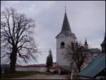
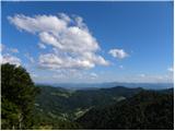
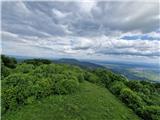
 | Javornik - Sveti Jošt above Kranj
Sveti Jošt above Kranj is a hill located west of the slightly lower Šmarjetna gora. From the summit, where the Church of St Jošt stands alongside...
40 min |
 | Rovišče - Zasavska Sveta gora (by road)
Zasavska Sveta Gora is a popular excursion destination located between Litija and Izlake. From the summit, where the parish church of the Nativit...
35 min |
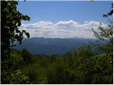
 | Križna Gora - Archangel Gabriel (Planica)
Planica is an 824-meter-high peak located north of Škofja Loka, more precisely between Križna gora and Planica. From the summit, where the church...
35 min |
 | Smrečje - Vrh Svetih Treh Kraljev (by road)
The Church of the Holy Three Kings stands on a panoramic hill above the village of Vrh Svetih Treh Kraljev. The summit features a panorama board ...
45 min |
 | Smrečje - Vrh Svetih Treh Kraljev (footpath)
The Church of the Holy Three Kings stands on a panoramic hill above the village of Vrh Svetih Treh Kraljev. The summit features a panorama board ...
40 min |
| Smrečje - Vrh Svetih Treh Kraljev (via Jereb)
The Church of the Holy Three Kings stands on a panoramic hill above the village of Vrh Svetih Treh Kraljev. The summit features a panorama board ...
45 min |
 | Dom na Paškem Kozjaku - Špik (Paški Kozjak)
Špik is the easternmost peak of the relatively long ridge of Paški Kozjak. From the summit, which has a summit register, the view is only towards...
30 min |
 | Hunting cottage Prehod - Jelenk
Jelenk is a mountain between the valley of the Idrijca River, above which it rises steeply, and the valley of the Kanomljica River. From the summ...
30 min |
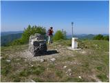
 | Pohorje cable car - Mariborski razglednik (Cigelnica)
Mariborski razglednik (Cigelnica) is a 1,147-meter-high peak located by the Mariborsko Pohorje ski resort. A lookout tower on the summit offers m...
25 min |
 | Travna Gora - Koča na Kamnem griču
The Koča na Kamnem griču mountain hut is located on Kamni grič, a panoramic hill rising southwest of Sodražica. From the grassy summit surrounded...
45 min |
 | Retjiški gozd - Koča na Kamnem griču
The Koča na Kamnem griču mountain hut is located on Kamni grič, a panoramic hill rising southwest of Sodražica. From the grassy summit surrounded...
25 min |
 | Velika vrata - Mala Plešivica
Mala Plešivica, higher than neighboring Velika Plešivica, is a panoramic peak located west of the village Golac near the Croatian border. On clea...
35 min |
 | Velika vrata - Velika Plešivica
Velika Plešivica is a 908-meter peak located between Slavnik and the lesser-known Mala Plešivica. The summit, which features a destroyed logbook ...
25 min |
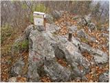
 | Kamen - Mokrc
Mokrc (Mokrec on maps) is a 1,059-meter-high mountain located east of Iški Vintgar. The summit is forested and offers no views.For some views, it...
40 min |
 | Zavratec - Medvedje Brdo
Medvedje Brdo is a small settlement located north of Hotedršica. The highest point of the village is a pleasant viewpoint on Šinkovcov grič (814 ...
45 min |
 | Dom na Govejku - Gontarska planina
Gontarska Planina is a 894-meter-high hill located between Osolnik and Tošč. From the summit, which features two benches, a splendid view opens t...
35 min |
 | Belo - Goljek
Goljek is an 809 m high peak located east of Polhograjska Grmada. From the summit, where remains of a former guard tower on the Italian-German bo...
40 min |
| Topol - Goljek (on west ridge)
Goljek is an 809 m high peak located east of Polhograjska Grmada. From the summit, where remains of a former guard tower on the Italian-German bo...
30 min |
 | Rakitna - Rotovc
Rotovc is a 964-meter-high peak situated northeast of Rakitna. From the summit, where a wooden bench stands, a beautiful view opens up toward the...
30 min |
 | Brancljeva senožet - Rotovc
Rotovc is a 964-meter-high peak situated northeast of Rakitna. From the summit, where a wooden bench stands, a beautiful view opens up toward the...
45 min |
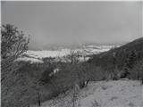
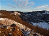
 | Čepulje - Špičasti hrib
Špičasti hrib (known as Špičasti vrh on maps) is an 837-meter-high hill located west of Sveti Jošt above Kranj. The summit, which has a few bench...
40 min |
 | Podlanišče - Veliki vrh (Lajše)
Veliki vrh is an almost 900-meter-high elevation rising south of Cerkno. From the summit, which features several television and radio transmitter...
40 min |
 | Solarji - Ježa
Ježa is a 949-meter-high peak located west of Volče, more precisely on the slopes of Kolovrat. From the summit, which has a logbook box with a bo...
45 min |
 | Solarji - Na gradu
Na gradu is a 1115 m high peak located in the middle of the Kolovrat range, precisely on the border between Slovenia and Italy. From the grassy s...
30 min |
 | Srednje - Globočak
Globočak is an 809 m high peak located in the Kanal Kolovrat range. From the summit, which has some remnants from the First World War, there is n...
35 min |
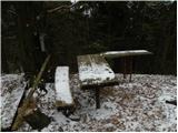
 | Mojstrana - Grančišče (south path)
Grančišče (also Grančiše) is a small precipitous hill rising west to southwest of Mojstrana. From the summit, where there is a bench and table, a...
25 min |
 | Dragonoš (Krpesovka) - Japetić
Japetić is the highest peak of the Samoborsko gorje. It is located in its western part and serves as the local mountain for the town of Jastrebar...
45 min |
 | Cenc - Špiček (Špečk)
Špiček (locals call it Špečk) is a peak located north to north-east of Col. A cross on the summit honors St. Hubert and commemorates the first an...
45 min |
 | Dražgoše (Jelenšče) - Dražgoška gora
Dražgoška gora is located on the southern slopes of Jelovica and covers a fairly extensive area northwest of Dražgoše. The name Dražgoška gora is...
30 min |
 | border crossing Remšnik - Sveti Pankracij (Radelca)
The Church of St. Pankracij on Radelca lies on the border ridge between Slovenia and Austria; since 1966, following an interstate agreement, it h...
25 min |
| Stružnica - Kuželjska stena
Kuželjska stena rises mightily above the village of Kuželj in the Kolpa River valley. It is a hill at a slope break, winding above the upper Kolp...
45 min |
 | Sedlo nad Lohačo - Špilnik (lower path)
Špilnik is a less visited but very panoramic peak on the southern side of Hrušica, more precisely above the village of Strmec. It holds a central...
30 min |
 | Pohorje cable car - Ledinekov kogel
Ledinekov kogel is a 1,182-meter-high peak located north of Mariborska koča. Just below the summit there is a fenced area with a radar tower....
40 min |
 | Waldgebiet - Großer Hirschenstein
Großer Hirschenstein is an 862-meter-high peak located west of the slightly higher Geschriebenstein / Írott-kő, the highest point in the Austrian...
30 min |
 | Rašpor - Gradina Rašpor (on marked path)
Gradina Rašpor are the ruins of a former castle above the village of Rašpor. Several information boards are by the ruins. Due to the surrounding ...
45 min |