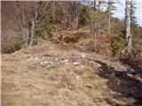
 | Volovljek - Kranjska reber (on unmarked path)
Kranjska reber, also known as Vrh Kašne planine (1435 m), is a mountain of volcanic origin. From the summit, which has a registration box with a ...
1 h 15 min |
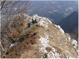
 | Kajfežev rob - Kamniški vrh
Kamniški vrh is a 1259-metre-high mountain located north of Kamnik, more precisely between Stahovica and the Korošica valley. From the summit, wh...
1 h 15 min |
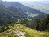
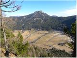
 | Brezje pri Tržiču - Vaško
Vaško is a little-known mountain in the southeastern ridge of Dobrča. From the summit, there is a nice view toward Jelovica and the Julian Alps. ...
55 min |
 | Brezje pri Tržiču - Vaško (eastern path)
Vaško is a little-known mountain in the southeastern ridge of Dobrča. From the summit, there is a nice view toward Jelovica and the Julian Alps. ...
1 h 5 min |
| Water storage Žegnani studenec - Vaško
Vaško is a little-known mountain in the southeastern ridge of Dobrča. From the summit, there is a nice view toward Jelovica and the Julian Alps. ...
1 h 5 min |
 | Dom na Lazni - Stanov rob
Stanov rob is a 1191-meter-high peak on the ridge of the precipitous Govce. From the summit, there are nice views over much of Govce, parts of th...
1 h 10 min |
 | Završnica (Pri žagi) - Smokuški vrh
Smokuški vrh is a panoramic mountain located on the ridge between the Završnica Valley and the Gorenjska plain. From the summit, where there is a...
1 h |
 | Planina pod Golico - Španov vrh
Španov vrh is a 1334-meter-high mountain in the Karavanke that rises between Javorniški Rovt and Planina pod Golico. From the scenic summit, acce...
1 h 15 min |
 | Planina Lom - Kobilja glava
Kobilja glava is a 1,475-meter-high peak located east of Tolmin. From the summit, where a cross stands, there is a beautiful view of Krn, the ran...
1 h 15 min |
 | Poljana - Smolnik
Smolnik is a steep 1075-meter-high peak a solitary summit below Valvasorjev dom hut rising above the Zavrh (Završnica) valley, with views of St...
1 h 15 min |
 | Poljana - Smolnik (steep path)
Smolnik is a steep 1075-meter-high peak a solitary summit below Valvasorjev dom hut rising above the Zavrh (Završnica) valley, with views of St...
1 h |
 | Ledinsko Razpotje - Gradišče (above Spodnja Idrija) (steep path)
Gradišče is a 998 m high peak that separates the Ledinska plateau in the northwestern part of Rovtarsko hribovje from the Idrijca valley. A telev...
1 h |
 | Ledinsko Razpotje - Gradišče (above Spodnja Idrija) (gentle path)
Gradišče is a 998 m high peak that separates the Ledinska plateau in the northwestern part of Rovtarsko hribovje from the Idrijca valley. A telev...
1 h 15 min |
 | Makekova Kočna - Skubrov vrh
Skubrov vrh is a 1276 m high mountain rising steeply above the Ravenska Kočna valley. The forested summit offers no views....
1 h 10 min |
 | Makekova Kočna - Turni
Turni is a lesser-known peak above the eponymous cliffs that rise above Planšarsko jezero. From the summit, which features a logbook box, a beaut...
1 h |
 | Matevljek - Petelinjek
Petelinjek is a 1212 m high peak located in the Racna gora range. From the summit, where there is a small metal chair, a cairn, and an old ladder...
1 h 15 min |
 | Rotek - Erbelc
Erbelc is a 1,308-meter-high peak that rises steeply above Zgornja Sorica. From the summit, which has a summit logbook, there is a fine view of t...
1 h 15 min |
| Spodnje Danje - Erbelc
Erbelc is a 1,308-meter-high peak that rises steeply above Zgornja Sorica. From the summit, which has a summit logbook, there is a fine view of t...
1 h 15 min |
 | Rotek - Tonderškofel
Tonderškofel is a 1,326-meter-high peak located between Soriška peč and Erbelc. From the partly overgrown summit, which has no marked trail leadi...
1 h 15 min |
| Spodnje Danje - Tonderškofel
Tonderškofel is a 1,326-meter-high peak located between Soriška peč and Erbelc. From the partly overgrown summit, which has no marked trail leadi...
1 h 15 min |
 | Planina pod Golico - Na pečeh at Črni Vrh
Na pečeh is a lesser-known panoramic peak at 1,318 meters above sea level, rising east above the village of Planina pod Golico. Before the Španov...
1 h 5 min |
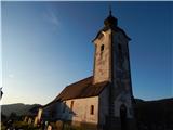
 | Bele Vode (Kovač) - Sveti Križ above Bele Vode (on south ridge)
The Church of St. Cross is located on Kriška gora, formerly called Oslovska gora. Kriška gora rises above Beli Vodi, or above the streams Ljubija...
1 h 10 min |
 | Koča na Pikovem - Jesenik (Jesenikov vrh)
Jesenik, also known as Jesenikov vrh, is a 1,199-meter-high forested peak situated between Mežica and Podpeca....
1 h 5 min |
 | Šenturška Gora - Prgozdnik (Martinova pot)
Prgozdnik is a 1013 meters high peak, which is situated on the eponymous ridge, between the settlements Ambrož pod Krvavcem, Šenturška Gora, Apno...
1 h 5 min |
 | Apno - Prgozdnik (Martinova pot)
Prgozdnik is a 1013 meters high peak, which is situated on the eponymous ridge, between the settlements Ambrož pod Krvavcem, Šenturška Gora, Apno...
1 h 10 min |
 | Koprivna (Šumel) - Sveti Jakob in Koprivna
The Church of St. Jakob in Koprivna stands on a panoramic rise above the right bank of the Meža River. It offers a beautiful view towards Raduha ...
50 min |
 | Završnica (Pri žagi) - Pleče
Pleče is a 1,131-meter-high peak located north of Sveti Peter above Begunje. The summit is overgrown with forest, but near the top some views ope...
1 h 5 min |
 | Erjavčev rovt - Bela peč (above Dovje)
Bela peč is a lesser-known peak located above the marked trail from Dovje to Dovška Baba. From the summit, there is a beautiful view to the south...
1 h 15 min |
 | Dovje - Blažčeva skala (western path)
Blažčeva skala is a 1,091-meter-high hill located northeast of Mojstrana and Dovje. The summit, known more among climbers than hikers due to the ...
1 h |
 | 2nd turn of Vršič road - Škrbinjek
Škrbinjek is a 1,341-meter-high peak in the Julian Alps and Triglav National Park. The summit is located 2 km south-southwest of Kranjska Gora or...
1 h |
 | Dražgoše (Jelenšče) - Britmanca
Britmanca is a 1,231-meter-high peak on the edge of the Jelovica plateau. Slightly south and lower from the summit along a well-worn path lies a ...
50 min |
| Dražgoše (Na Pečeh) - Britmanca
Britmanca is a 1,231-meter-high peak on the edge of the Jelovica plateau. Slightly south and lower from the summit along a well-worn path lies a ...
1 h 10 min |
| Dražgoše (Jelenšče) - Britmanca (gentle path)
Britmanca is a 1,231-meter-high peak on the edge of the Jelovica plateau. Slightly south and lower from the summit along a well-worn path lies a ...
1 h 15 min |