 | Cima Sappada - Creton di Tul
Creton di Tul is a 2,288-metre mountain in the Pesarina Dolomites group of the Carnic Alps in Italy, south of Sappada and west of the neighbourin...
3 h 30 min |
 | Sella Nevea - Velika Črnelska špica (on ski track)
Velika Črnelska špica is located in the Kanin mountains on the border between Italy and Slovenia. From the top there is a very nice view of the V...
4 h 30 min |
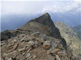
 | Planina Podvežak - Ojstrica (via Kocbekov dom)
Ojstrica, named for its sharp shape, rises steeply above Korošica, the Logarska Dolina valley, and Robanov Kot. From the summit, which has a regi...
4 h |
 | Planina Podvežak - Ojstrica (via Mala Ojstrica)
Ojstrica, named for its sharp shape, rises steeply above Korošica, the Logarska Dolina valley, and Robanov Kot. From the summit, which has a regi...
3 h 30 min |
| Planina Ravne - Ojstrica (via Mala Ojstrica)
Ojstrica, named for its sharp shape, rises steeply above Korošica, the Logarska Dolina valley, and Robanov Kot. From the summit, which has a regi...
4 h 15 min |
| Kraljev dol - Ojstrica (via Mala Ojstrica)
Ojstrica, named for its sharp shape, rises steeply above Korošica, the Logarska Dolina valley, and Robanov Kot. From the summit, which has a regi...
3 h 45 min |
| Kraljev dol - Ojstrica (via Kocbekov dom)
Ojstrica, named for its sharp shape, rises steeply above Korošica, the Logarska Dolina valley, and Robanov Kot. From the summit, which has a regi...
4 h 15 min |
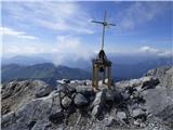
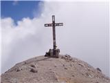
 | Jochalm - Reißkofel (235-1)
Reißkofel is a 2371 m high mountain in the Gailtal Alps. The summit, marked by a cross, also features a summit register. The view is particularly...
3 h |
 | Jochalm - Reißkofel (path 235)
Reißkofel is a 2371 m high mountain in the Gailtal Alps. The summit, marked by a cross, also features a summit register. The view is particularly...
3 h 25 min |
 | Bergheimat - Dachskofel (via Scharnik)
Dachskofel is a 2,373 m high mountain in Austria's Hohe Tauern above the town of Irschen and near Lamnitzsee. A wooden cross stands on the summit...
3 h 50 min |
 | Planina Pecol - Strma peč / Monte Cimone (path 640 via notch Vandul)
Strma Peč is located west of Montaž, more precisely between the Reklanica and Dunja valleys. From the summit, where a bivouac once stood, there i...
4 h |
 | Planina Podvežak - Planjava (via Srebrno sedlo)
Planjava is a smaller mountain group east of Kamniško sedlo. It has two peaks eastern and western. The marked path leads to the eastern peak, wh...
4 h 15 min |
 | Kraljev dol - Planjava (via Srebrno sedlo)
Planjava is a smaller mountain group east of Kamniško sedlo. It has two peaks eastern and western. The marked path leads to the eastern peak, wh...
4 h 30 min |
 | Passo Campolongo - Col di Lana
Col di Lana (Italian: also Col di Sangue, 'bloody mountain') is a 2,452-meter-high mountain located west of the Valparola and Falzarego passes. O...
4 h 20 min |
 | Passo di Sant'Antonio - Monte Aiarnola (via normale)
Monte Aiarnola is a mountain at the far eastern end of the Sexten Dolomites group. From it there is a nice view towards the western Carnic Alps, ...
3 h 30 min |
 | Cima Sappada - Creta Forata
Creta Forata is a 2,462-meter-high mountain in the Pesarina Dolomites group of the Carnic Alps in Italy, south of Sappada. A small cross and a st...
4 h |
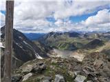
 | Sella di Razzo - Bivera (via Forcella Chiansaveit, Monte Clapsavon, Forcella de Bivera)
Monte Bivera is a 2,474-meter-high mountain in the Carnic Alps in Italy. It lies about an hour's walk east of the neighboring 2,462-meter-high Cl...
4 h |
 | Göriach - Scharnock
Scharnock is a panoramic peak located in the Schladminger Tauern group. From the summit, where a cross stands, there is a nice view of the surrou...
3 h 30 min |
 | Sella Nevea - Prestreljenik (via Rifugio Gilberti)
Prestreljenik is a 2,499 m high mountain located in the heart of the Kanin range. From the summit, where there is a registration box shaped like ...
4 h 15 min |
| Sella Nevea - Prestreljenik (via 636)
Prestreljenik is a 2,499 m high mountain located in the heart of the Kanin range. From the summit, where there is a registration box shaped like ...
3 h 45 min |
 | Dolina Dobri do - Bobotov kuk
Bobotov kuk is the highest peak of Durmitor. There are several routes to it. The southern approaches are the shortest, the eastern ones the longe...
2 h 45 min |
 | Vršič - Prisank / Prisojnik (Slovenian way)
Prisank (also known as Prisojnik) is a 2,547-meter-high mountain situated above the Mlinarica, Krnica, and Suha Pišnica valleys. From the summit,...
3 h 30 min |
| Erjavčeva koča na Vršiču - Prisank / Prisojnik (Slovenska pot)
Prisank (also known as Prisojnik) is a 2,547-meter-high mountain situated above the Mlinarica, Krnica, and Suha Pišnica valleys. From the summit,...
3 h 45 min |
 | Gschnitz - Kalkwand (western approach from Gschnitza via Pinnisjoch)
Kalkwand is an extensive mountain in the eastern part of the Habicht group in the central Stubai Alps. Due to its attractive views, relatively ea...
3 h 45 min |
 | Plockenpass - Cima di Mezzo / Keller Warte (via Rifugio Marinelli)
Cima di Mezzo (German: Keller Warte) is a 2,713-meter-high mountain in the Carnic Alps on the border between Austria and Italy. A small cross and...
4 h 35 min |
| Rifugio Tolazzi - Cima di Mezzo / Keller Warte (via Rifugio Marinelli)
Cima di Mezzo (German: Keller Warte) is a 2,713-meter-high mountain in the Carnic Alps on the border between Austria and Italy. A small cross and...
4 h |
 | Oberissalm - Vordere Sommerwand (normal path)
Sommerwand is a relatively long ridge rising as a massive rocky barrier above the upper part of the Oberbergtal valley, concealing from valley vi...
2 h 40 min |
 | Rifugio Tolazzi - Monte Coglians (Hohe Warte) (via Rifugio Marinelli)
Monte Coglians (Hohe Warte) is, at 2,780 meters, the highest mountain of the Carnic Alps. From the summit, which has a cross and a bell, there is...
4 h 25 min |
 | Ristorante Pietofana - Cima Formenton
Cima Formenton is a 2,830-meter-high peak in the Tofana group. The mountain lies north of the better-known Tofana di Dentro, with an unmarked tra...
3 h 40 min |
 | Kühtai - Finsteltaler Schartenkopf (western approach from Kühtai and via saddle Finstertal)
(Finsteltaler) Schartenkopf is a peak in the range above Kühtai. From the Finstertal saddlethe easiest access pointit appears quite indistinct, b...
4 h |
 | Göriach - Hochgolling (Normalanstieg)
Hochgolling is a 2863 m high peak (2862 m according to some sources), located in the heart of the Schladminger Tauern group. With its height, it ...
4 h |
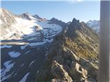
 | Passo Gardena - Cima Pisciadu (path 666)
Cima Pisciadu or Pisciadu Spitze is a 2,985-meter-high peak in the Sella mountain group. The mountain is located in the northern part of the grou...
3 h 40 min |
 | Oberissalm - Rinnenspitze (normal approach past Franz-Senn-Hütte)
Rinnenspitze is a beautifully conical mountain rising above its namesake lake. Though it does not stand out in the vast Alpine range for its heig...
3 h 45 min |
 | Passo Campolongo - Piz Lech Dlace (Lichtenfels)
The peak Piz Lech Dlace (German: Eisseespitze, Italian: Piz Lago Gelato) is located above Lake Lech Dlace (German: Eissee, Italian: Lago Gelato) ...
3 h 55 min |
 | Malga Ciapela - Cima Ombretta (via Passo Ombretta)
Cima Ombretta is a 3,011-meter-high peak in the Marmolada mountain group. From the summit, where a cross stands, there is the finest view of the ...
4 h 40 min |
 | La Crusc - Lavarella (western summit)
The western summit of Lavarella is a 3034-meter-high peak in the Lavarella group. Slightly lower than the eastern summit, it also has a marked tr...
4 h |
 | La Crusc - Lavarella
Lavarella (also La Varella) is the second-highest peak in the Lavarella group. From the summit, which has a cross, there are excellent views of t...
4 h |
 | Leibnitzbachbrücke - Hoher Prijakt
Hoher Prijakt is a 3,064-meter peak in the Schober group. From the summit, which has a summit register, there is a superb view of much of the gro...
4 h 15 min |
 | Passo Campolongo - Cresta Strenta (Lichtenfels)
Cresta Strenta is a less prominent peak north of Piz Boè. From the summit there is a superb view over much of the Dolomites. At 3,124 meters, Cre...
4 h 20 min |
 | Passo Campolongo - Piz Boe (Lichtenfels)
Piz Boe, at 3,152 meters, is the highest peak in the Sella group in the Italian Dolomites. From the summit, there are beautiful views of Marmolad...
4 h 35 min |
 | Rifugio Dibona - Tofana di Rozes (via Rifugio Giussani)
Tofana di Rozes is a 3225-meter-high peak located west of Cortina d'Ampezzo. From the top, where a cross stands, there is a nice view of the neig...
4 h |