 | Križe - Tolsti vrh (Sheep trail over Kriška gora)
Tolsti vrh, located west of Storžič, is at 1715 metres also the highest peak of the Kriška gora range, which rises steeply above central Gorenjsk...
3 h 45 min |
 | Tominčev slap Waterfall - Dobrča
Dobrča is a 1634-metre mountain located between Begunje and Tržič. From the summit, which has a registration box with a stamp, the view opens onl...
3 h |
 | Draga - Dobrča (via Ledena trata)
Dobrča is a 1634-metre mountain located between Begunje and Tržič. From the summit, which has a registration box with a stamp, the view opens onl...
3 h |
 | Hudi Graben - Dobrča (via Lešanska planina)
Dobrča is a 1634-metre mountain located between Begunje and Tržič. From the summit, which has a registration box with a stamp, the view opens onl...
2 h 35 min |
 | Grahovše - Veliki Javornik (Ženiklovec)
Veliki Javornik (also known as Ženiklovec) is a 1716 m high peak located between Storžič and Stegovnik. From the grassy summit with its registrat...
2 h 45 min |
 | Grahovše - Veliki Javornik (Ženiklovec) (via Rekar)
Veliki Javornik (also known as Ženiklovec) is a 1716 m high peak located between Storžič and Stegovnik. From the grassy summit with its registrat...
2 h 45 min |
 | Kraljev hrib - Rzenik (west path)
Rzenik is a grassy peak surrounded by dwarf pines that drops precipitously into the Kamniška Bela valley. From the summit, in clear weather, a wo...
3 h 40 min |
 | Volaka - Blegoš (on unmarked path)
Blegoš is a 1,562-metre-high mountain located between the Selška Sora and Poljanska Sora rivers. From the grassy summit, where there is a stamp a...
2 h 35 min |
 | Spodnja Kokra - Srednji vrh (via Baba)
Srednji vrh is an 1853 m high mountain located east of Storžič. From the summit, which features a bench, registration box and stamp, there is a b...
4 h 5 min |
 | Potoče - Javorov vrh (via Sveti Jakob, below Potoška gora and over Baba)
Javorov Vrh (recorded in some sources as Javorjev Vrh) is a 1,434 m high mountain northeast of Preddvor. The summit, with its registration box an...
2 h 55 min |
 | Mače - Bašeljski vrh (via valley of Suha and via Kališče)
Bašeljski vrh is a 1744-meter-high mountain located between Mali Grintovec and Storžič. From the summit, where there is a bench and a registratio...
3 h 25 min |
 | Dovje - Frauenkogel/Dovška Baba (via Blažčeva skala)
Dovška Baba is a 1891-meter-high peak located on the border ridge between Slovenia and Austria. From the summit, which has a registration box and...
3 h 15 min |
 | Ribčev Laz - Rodica (via Lepa Suha)
The mountain Rodica is located above Bohinj in the Lower Bohinj Mountains. From the summit there is a beautiful view over the Julian Alps and the...
4 h |
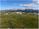
 | Kraljev hrib - Koritni vrh (Velika planina)
Koritni vrh is a 1648 m high mountain on the northern part of Velika planina. From the summit, where a small cross stands, there is a beautiful v...
3 h |
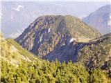 | Mojstrana - Drobeče Sleme
Drobeče Sleme is situated on the same ridge as the better-known Sleme. On this panoramic summit, from which Kukova Špica and Špik are nicely visi...
4 h 15 min |
 | Mojstrana - Vrtaški vrh (old path)
Vrtaški Vrh is a panoramic mountain above Vrata Valley. From the grassy peak, surrounded by dwarf pines, there is a nice view toward the neighbor...
3 h 30 min |
 | Javorje (Mala Črna) - Komen (via Hlipovec)
At 1684 meters, Komen is the highest peak in the Smrekovec mountain range, which borders between Styria and Carinthia. In good weather, the summi...
4 h 20 min |
 | Javorje (Mala Črna) - Veliki Travnik (Turnovka) (steep path)
Veliki Travnik, also known as Turnovka by the locals, is located on the western edge of the Smrekovec mountain range. From the summit, which has ...
4 h 25 min |
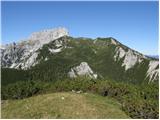
 | Potoče - Cjanovca (via Sveti Jakob, below Potoška gora and over Baba)
Cjanovca is a peak east of Storžič and south of Srednji vrh. It is clearly visible from Kranj and its surroundings. The southern slope is bare, w...
4 h 30 min |
| Spodnja Kokra - Cjanovca (via Baba)
Cjanovca is a peak east of Storžič and south of Srednji vrh. It is clearly visible from Kranj and its surroundings. The southern slope is bare, w...
3 h 50 min |
 | Ivarčko jezero - Uršlja gora (Plešivec) (Grofovska pot)
Uršlja gora, or Plešivec, is a panoramic mountain between Slovenj Gradec and Črna na Koroškem. At or just below the summit stands the Church of S...
2 h 50 min |
 | Zadnjica - Zadnjiški Ozebnik
Zadnjiški Ozebnik is a little-known mountain above Zadnjica valley. As no marked trail leads to the summit, it offers peace at the top. It provid...
4 h 15 min |
| Trenta - Zadnjiški Ozebnik
Zadnjiški Ozebnik is a little-known mountain above Zadnjica valley. As no marked trail leads to the summit, it offers peace at the top. It provid...
4 h 15 min |
 | Kneške Ravne - Vrh Planje (above Globoko)
Vrh Planje is a less prominent peak in the ridge of the Lower Bohinj Mountains, which has been increasingly visited lately. Vrh Planje (above Glo...
4 h 30 min |
| Ukanc - Vrh Planje (above Globoko) (via Globoko)
Vrh Planje is a less prominent peak in the ridge of the Lower Bohinj Mountains, which has been increasingly visited lately. Vrh Planje (above Glo...
4 h |
 | Bohinjska Bistrica - Krevl (on ski track)
Krevl is a 1515-meter-high peak situated south of the Kobla ski area, more precisely between the Kobla peak and Kravja Črna gora. From the summit...
2 h 45 min |
 | Podljubelj / Unterloibl - Singerberg / Žingarica
Žingarica / Singerberg is a peak on the Austrian side of the Karawanks above the village of Slovenji Plajberk / Windisch Bleiberg. From the summi...
3 h |
 | Draga - Šentanski vrh (via Ledena trata)
Šentanski vrh, located in the Dobrča range just five minutes from the main peak, offers a nice view of the central Karawanks, the Storžič group, ...
3 h 5 min |
 | Hudi Graben - Šentanski vrh (via Lešanska planina)
Šentanski vrh, located in the Dobrča range just five minutes from the main peak, offers a nice view of the central Karawanks, the Storžič group, ...
2 h 40 min |
| Hudi Graben - Šentanski vrh
Šentanski vrh, located in the Dobrča range just five minutes from the main peak, offers a nice view of the central Karawanks, the Storžič group, ...
2 h 35 min |
 | Grant - Jehlc (Špičasta kupa)
Different maps list various names for Jehlc, which also vary in elevation. Locals call the peak Jehlc (1625 m), while newer maps show Jehelc and ...
2 h 45 min |
| Stržišče - Jehlc (Špičasta kupa)
Different maps list various names for Jehlc, which also vary in elevation. Locals call the peak Jehlc (1625 m), while newer maps show Jehelc and ...
3 h 30 min |
 | Koča pri Savici - Vrh Škrli
Vrh Škrli is a 1,926-meter-high mountain located above the Spodnja Komna plateau. From its grassy summit, over which the national border once ran...
4 h 30 min |
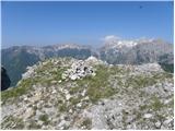
 | Stara Fužina - Krsteniški Stog (čez Krsteniški preval)
Krsteniški Stog, or Mali Stog, is a 1879 m high mountain rising steeply above the Krstenica mountain pasture. From the summit, where a stone cair...
4 h 15 min |
 | Podbrdo - Rušni vrh
Rušni vrh is a 1,786-meter-high peak located east of Črna Prst. From the summit, which features a border stone from the old Rapallo border, a bea...
3 h 5 min |
 | Petrovo Brdo - Rušni vrh
Rušni vrh is a 1,786-meter-high peak located east of Črna Prst. From the summit, which features a border stone from the old Rapallo border, a bea...
4 h 30 min |
| Bohinjska Bistrica - Rušni vrh (via Planina za Črno goro)
Rušni vrh is a 1,786-meter-high peak located east of Črna Prst. From the summit, which features a border stone from the old Rapallo border, a bea...
3 h 50 min |
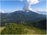 | Luče - Kup (on Raduha)
Kup is a 1,808-meter-high peak situated on the far northeastern part of Raduha. From the summit, where a cross stands, a beautiful view opens up ...
4 h 5 min |
 | Radovna - Vošni vrh
Vošni vrh is a 1,621-meter-high mountain located in the ridge that begins at Radovna and ends at Tosc. Although the summit itself is in the fores...
3 h |
 | Ribčev Laz - Hunting cottage Na Glinu
The hunting cottage Na Glinu is situated on a panoramic hill between the mountain pastures Suha and Poljana. From the cottage there opens a nice ...
3 h 30 min |
 | Kneške Ravne - Grušnica (via Planina na Kalu)
Grušnica is a 1,570-meter-high peak located between Čadrg, the Tolminka valley, and Tolminske Ravne. From the summit, which drops steeply toward ...
4 h 30 min |
 | Kranjska Gora - Visoka peč (via Bedančev dom)
Visoka peč is a 1,749-meter-high mountain located southwest of Ciprnik. From its summit, which steeply descends towards Planica and features a sm...
3 h 25 min |
 | Dom v Lepeni - Velika Montura
Velika Montura is a panoramic peak located between Velika Baba, Lanževica, Bogatin, and Veliki Šmohor. Just below the summit are old Italian bord...
3 h 55 min |
 | Rebrca / Rechberg - Stara gora / Altberg (via Bukovnik)
Stara gora is a 1,552-meter-high peak located northeast of Ojstrca, the highest peak of Obir. On the summit stand a wooden cross and a bench, wit...
2 h 50 min |
| Rebrca / Rechberg - Stara gora / Altberg (via Rokov vrh)
Stara gora is a 1,552-meter-high peak located northeast of Ojstrca, the highest peak of Obir. On the summit stand a wooden cross and a bench, wit...
3 h 10 min |
 | Sele-Zvrhnji Kot (Male) / Zell-Oberwinkel (Male) - Hajnžev Praprotnik / Zeller Prapotnik
Hajnžev Praprotnik is a 1,727-metre peak on the Austrian side of the Karawanks, more precisely between Košutica and the settlement of Sele-Zvrhnj...
3 h 55 min |
 | Bistrica v Rožu / Feistritz im Rosental - Rabenberg
Rabenberg is a 1,465 m high peak located in the Žingarica / Singerberg ridge. From the summit, there is a partial view to the northwest, while fo...
3 h 20 min |
 | Spodnja Trenta - Na Glavi
Na Glavi (or Na Glavah) is a 1,666-meter-high peak above Stari Utro. From the summit, overgrown with dwarf pines, there is a very nice view of nu...
3 h 25 min |
 | Ombrico - Monte Gosadon
Monte Gosadon is a somewhat less-visited peak in the Naborjet Mountains group. The surroundings of the peak also feature quite a few remains from...
3 h 40 min |
 | Aflenz Kurort (Freibad Aflenz) - Hochstein (at Mitteralm) (via Windgrube)
Hochstein is a scenic summit with a cross and summit register box in the Hochschwab mountain group, between Windgrube peak and the Mitteralm plat...
3 h 35 min |
 | Aflenz Kurort (Freibad Aflenz) - Schönleitenhaus (Windgrube) (on southern ridge)
The Schönleitenhaus hut is located just a few meters below the Windgrube summit. From the hut or the summit, there is a beautiful view of the sur...
3 h |