 | Iverje - Kamniški vrh (via Hudi Konci)
Kamniški vrh is a 1259-metre-high mountain located north of Kamnik, more precisely between Stahovica and the Korošica valley. From the summit, wh...
2 h 15 min |
 | Stara baba - Sinji vrh
Sinji vrh is a panoramic mountain between Col, Ajdovščina, and Predmeja. It offers views across much of western Slovenia (the sea on clear days)....
1 h 45 min |
 | Jamce - Sinji vrh (west path)
Sinji vrh is a panoramic mountain between Col, Ajdovščina, and Predmeja. It offers views across much of western Slovenia (the sea on clear days)....
2 h 45 min |
 | Cerkno - Bevkov vrh (via Lajše)
Bevkov vrh, a control point on the Slovenian Mountain Trail, is located between Cerkno and Spodnja Idrija. The peak is forested, but the stamp is...
3 h |
 | Divje jezero - Hleviška planina (via Strug)
Hleviška planina (also Hleviške planine) is a slightly vegetated but still very panoramic peak. From the summit, the home mountain of Idrija, the...
1 h 45 min |
 | Spodnje Stranice (graves of hundred hostages) - Stolpnik (by road)
Stolpnik, at 1012 meters, is the highest peak of Konjiška gora, a range stretching southwest from Slovenske Konjice. A 25-meter-high observation ...
2 h |
 | Jablance - Skalica (Bohor) (via Travni laz)
Skalica is a lesser-known peak on the western part of Bohor. From the summit, which has a logbook box, there is a nice view to the south and west...
2 h |
 | Rodine - Smokuški vrh (via Sankaška koča)
Smokuški vrh is a panoramic mountain located on the ridge between the Završnica Valley and the Gorenjska plain. From the summit, where there is a...
1 h 45 min |
 | Prešnica - Grmada at Slavnik
Grmada is a 1,001-meter-high peak located northwest of Slavnik. The summit hosts a fire watchtower, offering fine views over much of Primorska....
1 h 50 min |
 | Jamce - Kovk
Kovk is a panoramic peak west of Col on an elongated ridge rising steeply above the Vipava Valley. From the summit cross, beautiful views extend ...
2 h 10 min |
 | Vitovlje - Čaven
Čaven is a forested peak located west of Veliki Rob (1237 m). No marked trail leads to the summit, despite its very well-known name, even though ...
2 h 30 min |
| Vitovlje - Čaven (via Vitovlje Lake)
Čaven is a forested peak located west of Veliki Rob (1237 m). No marked trail leads to the summit, despite its very well-known name, even though ...
2 h 40 min |
 | Vitovlje - Hunting cottage below Čaven
The hunting cottage below Čaven is situated on a panoramic hill on a side ridge of Čaven. From the cottage, which serves as an emergency bivouac,...
1 h 50 min |
 | Zabočevo - Novaška gora
Novaška gora is a forested peak located west of Rakitna....
2 h |
 | Potoče - Baba (via sv. Jakob and source below Potoška gora)
Baba is a 1,119-meter-high peak located west of the Dom Čemšenik mountain hut. The summit, which has a logbook box, offers fine views of the Gore...
2 h 10 min |
 | Lozice - Grmada (Nanos)
Grmada is a 1209-meter peak situated near the edge of the Nanos plateau, northwest of the better-known Pleša (about a 20-minute walk away). Becau...
2 h 55 min |
 | Radlje ob Dravi - Kapunar / Kapunerkogel (on unmarked path)
Kapunar is a 1,051-meter-high peak above Radlje ob Dravi. Just below the summit stands an old customs post and border guardhouse, now used by ama...
2 h 15 min |
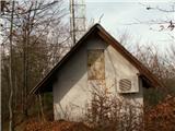 | Spodnja Idrija - Gradišče (above Spodnja Idrija) (via Grič)
Gradišče is a 998 m high peak that separates the Ledinska plateau in the northwestern part of Rovtarsko hribovje from the Idrijca valley. A telev...
2 h |
 | Spodnja Idrija - Gradišče (above Spodnja Idrija) (via Trnje)
Gradišče is a 998 m high peak that separates the Ledinska plateau in the northwestern part of Rovtarsko hribovje from the Idrijca valley. A telev...
2 h 15 min |
 | Žovneško jezero - Vrhe
Vrhe is a forested peak located east of the Church of the Holy Mother of God on Čreta. There are no views from the summit due to the forest....
2 h 25 min |
| Braslovško jezero - Vrhe
Vrhe is a forested peak located east of the Church of the Holy Mother of God on Čreta. There are no views from the summit due to the forest....
2 h 55 min |
| Letuš - Vrhe
Vrhe is a forested peak located east of the Church of the Holy Mother of God on Čreta. There are no views from the summit due to the forest....
2 h 55 min |
 | Cerkno - Škofje (on unmarked path)
Škofje is a 973-meter-high peak located above the villages of Čeplez, Planina pri Cerknem, and Podpleče. The summit itself, marked by a small con...
1 h 45 min |
 | Vitanje - Stenica (via valley of the stream Jez)
Stenica is a 1091-meter-high peak located between Vitanje, Stranice, and Frankolovo. The summit, which features a stamp, logbook, and bench with ...
1 h 50 min |
 | Loke - Javor
Javor is a 1,132-meter-high peak situated between Kisovec and Sveta Planina. The summit, covered with forest, offers no views, but a nice panoram...
2 h 25 min |
 | Trbovlje - Javor
Javor is a 1,132-meter-high peak situated between Kisovec and Sveta Planina. The summit, covered with forest, offers no views, but a nice panoram...
2 h 30 min |
 | Kokra (resting place Kokra-sotočje) - Kopa (Partizanski vrh)
Kopa, also known as Partizanski vrh, is a 1,024-meter-high mountain located west of the Davovec saddle, which itself lies west to southwest of Kr...
1 h 45 min |
 | Spodnja Kokra - Skutman (via Kopa)
Skutman is a lesser-known peak above the left bank of the Kokra River and north of Štefanja Gora. The summit is marked by a metal plaque reading ...
2 h |
 | Bled (Velika Zaka) - Hotunjski vrh
Hotunjski vrh is a 1,107-meter-high panoramic peak located above the Zatrnik ski slope. From the summit, where there is a summit register box and...
2 h 30 min |
| Bohinjska Bela (St. Marjeta) - Hotunjski vrh
Hotunjski vrh is a 1,107-meter-high panoramic peak located above the Zatrnik ski slope. From the summit, where there is a summit register box and...
2 h 15 min |
 | Bled (Velika Zaka) - Turn (above Bohinjska Bela)
Turn is a panoramic and precipitous peak located above Bohinjska Bela. From the summit, there is a nice view of Ratitovec, Jelovica, the Kamnik-S...
3 h 15 min |
 | Njivica - Bela peč (Podbliška gora)
Bela peč is situated on the edge of Jelovica above the village Podblica. From the top of the cliff a beautiful view opens up towards the mentione...
2 h 35 min |
| Nemilje - Bela peč (Podbliška gora) (via Sleme)
Bela peč is situated on the edge of Jelovica above the village Podblica. From the top of the cliff a beautiful view opens up towards the mentione...
2 h 25 min |
 | Kropa - Bela peč (Podbliška gora) (via tehnika Meta)
Bela peč is situated on the edge of Jelovica above the village Podblica. From the top of the cliff a beautiful view opens up towards the mentione...
3 h |
 | Libeliče - Šteharski vrh (Šteharnikov vrh) (via Trotov križ)
Šteharski vrh (also Šteharnikov vrh or Črneška gora) is a 1,018 m high mountain located in the southeastern part of the Strojna range, between th...
3 h |
 | Leše - Hom (above Prevalje) (via Kot pri Prevaljah)
Hom is a 1,193 m high peak situated between Uršlja gora and Prevalje. On the summit is a register box with logbook, but the view is quite limited...
2 h 40 min |
| Prevalje - Hom (above Prevalje)
Hom is a 1,193 m high peak situated between Uršlja gora and Prevalje. On the summit is a register box with logbook, but the view is quite limited...
3 h |
 | Mežica - Jesenik (Jesenikov vrh) (via saddle Vrh šteng)
Jesenik, also known as Jesenikov vrh, is a 1,199-meter-high forested peak situated between Mežica and Podpeca....
2 h |
 | Mežica - Jesenik (Jesenikov vrh) (via homestead Jesenik)
Jesenik, also known as Jesenikov vrh, is a 1,199-meter-high forested peak situated between Mežica and Podpeca....
2 h 5 min |
 | Mežica - Pikov vrh (via homestead Jesenik)
Pikov vrh is a 1,149-meter-high peak located above Podpeča, more precisely above the Pik homestead, near the Koča na Pikovem mountain hut. On the...
2 h |
 | Mežica - Veliki vrh (above Mežiška dolina) (via Pikov vrh)
Veliki vrh is a 1,165-meter-high peak located between Mežica and Črna na Koroškem. On the summit, beside the television transmitters, there is a ...
2 h 40 min |
 | Mežica - Šumahov vrh (via Pikov and Veliki vrh)
Šumahov vrh is a 1,155-meter-high peak on which a wooden cross stands. From the summit, which descends steeply towards Žerjav, a nice view opens ...
3 h 5 min |
 | Libeliče - Pokeržnikov vrh
Pokeržnikov vrh is a 1,055-meter-high peak situated above the settlement of Strojna in the Municipality of Ravne na Koroškem. From the summit, wh...
2 h 15 min |
| Ravne na Koroškem - Pokeržnikov vrh (via Šteharski vrh)
Pokeržnikov vrh is a 1,055-meter-high peak situated above the settlement of Strojna in the Municipality of Ravne na Koroškem. From the summit, wh...
3 h 15 min |
 | Libeliče - Šteknetov vrh (via Trotov križ)
Šteknetov vrh, also marked as Štekneči vrh on some maps, is a 1,061-meter-high peak located between Požegov vrh and Šteharski vrh. The forest-cov...
2 h 20 min |
 | Rodine - Pleče (via Sankaška koča)
Pleče is a 1,131-meter-high peak located north of Sveti Peter above Begunje. The summit is overgrown with forest, but near the top some views ope...
1 h 50 min |
 | Bresternica (Spodnji Rušnik) - Možičev vrh (via Žavcarjev vrh)
Možičev vrh is a 926-meter-high peak located west of the more famous but slightly lower Žavcarjev vrh. A cart track leads to the summit, but due ...
1 h 55 min |
 | Činžat - Lamprehtov vrh
Lamprehtov vrh is a 1,230-metre peak in the Pohorje Mountains, located northeast of Klopni vrh....
2 h 30 min |
 | Zgornja Bistrica (Center Vintgar) - Repnikov vrh (via Veliko Tinje)
Repnikov vrh is a 988-meter-high peak on Pohorje, located between Planina pod Šumikom and Urh. The summit is in the middle of the forest, along a...
2 h 45 min |
| Zgornja Bistrica (Center Vintgar) - Repnikov vrh (via Bistriški vintgar)
Repnikov vrh is a 988-meter-high peak on Pohorje, located between Planina pod Šumikom and Urh. The summit is in the middle of the forest, along a...
3 h 15 min |
 | Mixnitz (parking lot Bärenschützklamm) - Rannerwandkreuz
Rannerwandkreuz is a rocky promontory on the ridge of Ranerwand hill in the Graz Mountains in Austrian Styria.From the rocky promontory, where a ...
1 h 45 min |
 | Mixnitz (parking lot Bärenschützklamm) - Ranerwand
Ranerwand is a 1,308-meter-high peak in the Graz Mountains. It is not an independent summit but the western continuation of the mountain ridge le...
2 h 30 min |
 | Janževa Gora - Kranjčeva pečina (past church of St. Janez Krstnik)
Kranjčeva pečina is located above the Kranjc homestead in the Kozjak range. A logbook box is on the panoramic cliff, with views mainly towards th...
2 h 10 min |
 | Muta (Zgornja Muta) - Napečnikov vrh
Napečnikov vrh is located near the marked path which leads from Muta towards Pernice. The peak itself is situated in the forest, only about a min...
2 h 10 min |