 | Tourist farm Gonte - Tošč
Tošč, which became the highest peak of the Polhov Gradec Hills decades ago when the Yugoslav army lowered Pasja ravan by 9 metres, is located nor...
45 min |
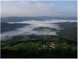
 | Breznica - Lubnik
Lubnik is a 1025 m high mountain that rises steeply west of Škofja Loka. From the summit, where a mountain hut stands, there is a beautiful view ...
40 min |
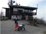 | Zamlake - Krim
Krim is a 1,107-metre-high mountain rising south of the Ljubljana Marsh. From the summit, where a mountain hut and several transmitters stand, th...
50 min |
 | Lontovž - Kum (by road)
Kum, at 1,220 metres, is the highest peak in the Posavje Hills. As it rises above the Zasavje region, some call it the Zasavje Triglav. At the su...
50 min |
| Lontovž - Kum (footpath)
Kum, at 1,220 metres, is the highest peak in the Posavje Hills. As it rises above the Zasavje region, some call it the Zasavje Triglav. At the su...
40 min |
 | Preval - Stari vrh
Stari Vrh is a 1,217-metre-high mountain located above the ski resort of the same name. There is no view from the summit itself due to the forest...
50 min |
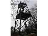
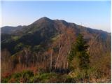
 | Črni Vrh - Pasja ravan
Pasja ravan is the second-highest peak in the Polhograjsko hribovje. A few decades ago, at 1029 meters, it was the highest, but in the second hal...
1 h |
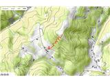
 | Selo - Mlaka
Mlaka or Prosenov grič is a forested peak between Pasja ravan and Tošč. Due to the forest, the peak has no view....
1 h 10 min |
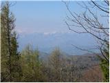
 | Krvavi kamen - Trdinov vrh
Trdinov vrh (1178 m) is the highest point in the Gorjanci range, across which the state border between Slovenia and Croatia runs. Although the su...
40 min |
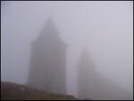
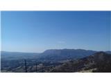
 | Sevski gozd - Sveta Trojica
Sveta Trojica is a distinctly panoramic 1106-meter peak located southwest of the Javorniki. From the summit, where a beautifully restored histori...
45 min |
 | Vrbiški dol - Koča na Kozleku
The Koča na Kozleku mountain hut is situated southwest of Ilirska Bistrica, just a few meters below the summit of Kozlek. From the summit, there ...
1 h |
 | Ledine - Sivka
Sivka is a forested peak located west of Žiri and north of Idrija. At the summit there is a stamp for the Slovenian Mountain Trail and a logbook ...
45 min |
 | Komarna vas - Gače
Gače is a popular excursion spot for nature lovers and the only ski center in Dolenjska (SC Bela), offering pleasant skiing in winter and enjoyab...
1 h |
 | Tuškov Grič - Črni vrh above Novaki
Črni vrh, the highest point of the popular Cerkno ski center, is located northeast of Novaki. Near the summit, where an artificial lake has been ...
45 min |
 | Štufna - Veliki Rog
Veliki Rog lies in the middle of the endless forests of the karst plateau Kočevski Rog and, at 1,099 meters above sea level, is its highest peak....
50 min |
 | Mali Log - Koča na Kamnem griču
The Koča na Kamnem griču mountain hut is located on Kamni grič, a panoramic hill rising southwest of Sodražica. From the grassy summit surrounded...
50 min |
 | Lom - Koča na Kamnem griču
The Koča na Kamnem griču mountain hut is located on Kamni grič, a panoramic hill rising southwest of Sodražica. From the grassy summit surrounded...
45 min |
 | Hunting cottage Urška - Racna gora
Racna gora is a little-visited peak rising east of Loška dolina. From the summit, which has a logbook box and stamp, there is no view due to the ...
45 min |
 | Kampelc - Čelkov vrh
Čelkov vrh is a 1,106-meter peak south of Črni vrh. From the summit, which has a logbook box and stamp, there are fine views toward the Julian Al...
50 min |
 | Krnica - Veliki Rob
Veliki Rob is a panoramic peak situated between Kuclj (1237 m) and Čaven (1185 m). From the summit, where there is a cross, there is a nice view ...
40 min |
 | Lipa - Smolnik
Smolnik is a 1002-meter-high mountain situated between Menina planina and Dobrovlje. From the summit, where there is a bench, a stamp box and a s...
55 min |
 | Kamen - Mokrc
Mokrc (Mokrec on maps) is a 1,059-meter-high mountain located east of Iški Vintgar. The summit is forested and offers no views.For some views, it...
40 min |
 | Borovec pri Kočevski Reki - Krempa
Krempa is a 944 m high mountain located in the central part of Borovška gora, a range that rises steeply above Zgornja Kolpska dolina. On the sum...
50 min |
 | Petrovo Brdo - Kup
Kup is a 1,046-meter-high peak located between Petrovo Brdo and Podbrdo. From the summit, which features a cross and several transmitters, there ...
45 min |
 | Suhi Dol - Goli vrh (Official marked path)
Goli vrh (also Golni vrh on maps) is an indistinct, forest-covered peak above the dispersed settlement of Goli Vrh. There is no view from the sum...
1 h |
 | Podlanišče - Škofje
Škofje is a 973-meter-high peak located above the villages of Čeplez, Planina pri Cerknem, and Podpleče. The summit itself, marked by a small con...
1 h 10 min |
 | Lokve - Škol
Škol is a 1182 m high peak that rises steeply above Čepovanski dol, more precisely above the village of Lokve on the edge of the Trnovski gozd pl...
40 min |
 | Planinski dom pod Ježo - Deveti konfin (survey point 930)
Deveti konfin at survey point 930 is located along the marked path leading from Planinski dom pod Ježo towards Očna. From the meadow a few meters...
55 min |
 | Planinski dom pod Ježo - Deveti konfin (survey point 942)
Deveti konfin at survey point 942 is one of two peaks of Deveti konfin in the Kolovrat range, located between Ježa and Očna. From the summit, whe...
45 min |
 | Cvetrež - Lašček
Lašček, at 1071 m, is the highest peak of the Banjška planota plateau, rising above Čepovanski dol, the Soča valley, and the Idrijca valley. From...
1 h |
 | Bele Vode (Sveti Andrej) - Sveti Križ above Bele Vode (upper path)
The Church of St. Cross is located on Kriška gora, formerly called Oslovska gora. Kriška gora rises above Beli Vodi, or above the streams Ljubija...
1 h |
 | Lipovnik - Šteharski vrh (Šteharnikov vrh)
Šteharski vrh (also Šteharnikov vrh or Črneška gora) is a 1,018 m high mountain located in the southeastern part of the Strojna range, between th...
45 min |
 | saddle above Lohača - Špilnik (upper path - via Lipovec)
Špilnik is a less visited but very panoramic peak on the southern side of Hrušica, more precisely above the village of Strmec. It holds a central...
40 min |
 | Sveta Katarina (Zgornja Kapla) - Sršenov vrh
Sršenov vrh is a 963-meter-high peak located in the Kozjak hills, more precisely between Ožbalt and Zgornja Kapla. The summit itself offers no sp...
1 h |
 | Dom na Osankarici - Veliki vrh (on Pohorje)
Veliki vrh is a 1344-meter-high peak located above the RTC Jakec - Trije kralji ski slope. The highest point of the peak is in the forest, but ju...
55 min |
 | Planinska koča Promina - Čavnovka (Promina) (on footpath)
Čavnovka is the highest summit of Promina, a smaller range above the town of Drniš. There are two summits: the southern one features an antenna, ...
1 h |
 | Planinska koča Promina - Čavnovka (Promina) (on road)
Čavnovka is the highest summit of Promina, a smaller range above the town of Drniš. There are two summits: the southern one features an antenna, ...
1 h |
 | Nechnitz - Gschaidberg
Gschaidberg (also Gschaid-Nock or simply Gschaid) is a 1,239 m high mountain in the Graz Mountains in Austria's Styria.It is part of the Almenlan...
45 min |
 | Slavica - Velika Slavica
Velika Slavica is a lesser-known peak above the village of Slavica, which lies between Vrata and Delnice. The summit has a logbook box. From the ...
1 h |
 | Omar - Kolevrat
Kolevrat is a lesser-known peak situated above Klenovica. It lies near the path to Kolovratske stijene. From the grassy summit, which has a logbo...
1 h |
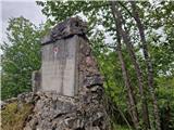 | Sokoli - Sokolske stijene
Sokolske stijene is a lesser-known peak south of the more famous Rudnik, specifically above the hamlet of Sokoli. A monument and summit logbox ar...
45 min |
 | Frbežari - Rudnik (on ski slope)
Rudnik is a peak in the northern part of Gorski Kotar, specifically above the place Tršće, near the Slovenian border. The peak is an HPO point an...
45 min |