 | Korensko sedlo - Ofen/Peč
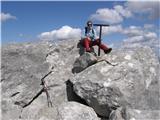
Peč (also known as Tromeja; in Italian Monte Forno, in German Dreiländereck or Ofen) is a 1508 m high peak located at the tripoint between Sloven...
2 h |
 | Korensko sedlo - Ofen/Peč (on marked path)
Peč (also known as Tromeja; in Italian Monte Forno, in German Dreiländereck or Ofen) is a 1508 m high peak located at the tripoint between Sloven...
2 h |
 | Dom pod Storžičem - Bela peč
The mountain, known mainly among climbers, is located north of Storžič on the slopes of Konjščica. From the summit there is a beautiful view of t...
2 h |
| Dom pod Storžičem - Bela peč (via Javorniški preval)
The mountain, known mainly among climbers, is located north of Storžič on the slopes of Konjščica. From the summit there is a beautiful view of t...
2 h 5 min |
 | Na kopiš - Bela peč (via Spodnja and Zgornja Konjščica)
The mountain, known mainly among climbers, is located north of Storžič on the slopes of Konjščica. From the summit there is a beautiful view of t...
2 h |
 | Bohinjsko sedlo - Kobla
The summit is located in the Lower Bohinj Mountains between Črna prst and Soriška planina. Directly below it is a railway tunnel connecting Bohin...
2 h 35 min |
 | Bohinjsko sedlo - Šavnik (by Lajnar)
Šavnik is a grassy peak situated between the ski resorts of Soriška Planina and Kobla. From the summit, which has a registration box with a stamp...
2 h |
 | Furlanovo zavetišče pri Abramu - Vojkova koča na Nanosu
Vojkova koča is located on the southern edge of the high karst Nanos plateau, near Pleša. This is the prominent peak with television transmitters...
2 h |
 | Golte (Alpine garden) - Smrekovec
Smrekovec is a mountain of volcanic origin on the eastern edge of the Smrekovec mountain range. The wide grassy summit features a pyramid with a ...
2 h 30 min |
 | Predmeja - Kucelj (on Čaven)
Kucelj is located on the southern slopes of the Trnovski Forest, northwest of the Vipava Valley. From the bare summit, where a cross stands, ther...
2 h |
 | Koča Edmunda Čibeja v Tihi dolini - Mali Golak
Mali Golak is the highest peak in the Golaki group at 1495 meters above sea level and at the same time the highest point of the entire Trnovski g...
2 h |
| Predmeja (Gorjanka) - Mali Golak
Mali Golak is the highest peak in the Golaki group at 1495 meters above sea level and at the same time the highest point of the entire Trnovski g...
2 h 25 min |
 | Koča na Klopnem vrhu - Rogla
Rogla is a peak in the middle of the eponymous ski resort. The peak is forested with a small clearing on which stands a lookout tower. The tower ...
2 h 45 min |
 | Koča na Pesku - Jezerski vrh (via Lovrenška jezera)
Jezerski vrh is located on Ribniško Pohorje near the Ribniška koča mountain hut. Due to the unvegetated peak, there is a nice view of Pohorje and...
3 h 20 min |
| Rogla (Hotel Planja) - Jezerski vrh (via Lovrenška jezera)
Jezerski vrh is located on Ribniško Pohorje near the Ribniška koča mountain hut. Due to the unvegetated peak, there is a nice view of Pohorje and...
3 h 15 min |
| Rogla (Hotel Planja) - Jezerski vrh
Jezerski vrh is located on Ribniško Pohorje near the Ribniška koča mountain hut. Due to the unvegetated peak, there is a nice view of Pohorje and...
3 h 5 min |
 | Bohinjsko sedlo - Krevl
Krevl is a 1515-meter-high peak situated south of the Kobla ski area, more precisely between the Kobla peak and Kravja Črna gora. From the summit...
2 h 50 min |
 | Dom na Paškem Kozjaku - Basališče (Paški Kozjak)
Basališče is the highest peak of Paški Kozjak. A bench and a summit register have been placed on the summit. However, due to the forest, there is...
2 h |
 | Usek - Huhnerkogel/Košenjak (mimo sv. Urbana)
Košenjak is located north of Dravograd and the Drava River on the border with neighbouring Austria. Access to Košenjak is possible on foot or by ...
2 h |
 | St. John the Baptist on Ojstrica - Huhnerkogel/Košenjak (via Bivak Piramida)
Košenjak is located north of Dravograd and the Drava River on the border with neighbouring Austria. Access to Košenjak is possible on foot or by ...
2 h |
 | Jezero Sobote / Stausee Soboth - Huhnerkogel/Košenjak (on marked path)
Košenjak is located north of Dravograd and the Drava River on the border with neighbouring Austria. Access to Košenjak is possible on foot or by ...
2 h |
 | Plajberški graben / Bleiberger Graben - Singerberg / Žingarica
Žingarica / Singerberg is a peak on the Austrian side of the Karawanks above the village of Slovenji Plajberk / Windisch Bleiberg. From the summi...
2 h 20 min |
 | Kampelc - Javornik (above Črni Vrh)
Javornik is a forested peak located southeast of Črni Vrh. In 1972, a wooden observation tower was built on it, rising above the treetops and off...
2 h 15 min |
 | Platak - Veliki Risnjak
Veliki Risnjak, at 1528 m, is the highest peak of Risnjak National Park. From the summit, which has a logbook box and stamp, there is a very nice...
3 h 30 min |
 | Platak - Vidikovac
Vidikovac is a 1,408-meter-high peak in Gorski Kotar. From its partly unforested summit, there is a very beautiful view of the nearby Veliki Risn...
2 h 45 min |
 | Črni Kal - Mladi vrh (via Koprivnik)
Mladi vrh is the higher neighbor of the better-known Stari vrh, separated from it by a saddle. Covered in sparse beech forest, the summit offers ...
2 h 15 min |
| Preval - Mladi vrh
Mladi vrh is the higher neighbor of the better-known Stari vrh, separated from it by a saddle. Covered in sparse beech forest, the summit offers ...
2 h |
 | Predmeja - Veliki Rob
Veliki Rob is a panoramic peak situated between Kuclj (1237 m) and Čaven (1185 m). From the summit, where there is a cross, there is a nice view ...
3 h |
| Polomova rajda - Veliki Rob (via Kucelj)
Veliki Rob is a panoramic peak situated between Kuclj (1237 m) and Čaven (1185 m). From the summit, where there is a cross, there is a nice view ...
2 h 45 min |
 | Soriška peč - Kačji rob (Ovharn)
Kačji rob (Ovharn) is a 1,552 m high peak situated between the Zgornji Jirn mountain pasture and the lesser-known Žbanjek peak. From the summit, ...
2 h 30 min |
 | Tuškov Grič - Medrce (by road)
Medrce is a 1,410-meter-high peak located between Porezen and Hum. From the summit, which features an old bunker, there are nice views of Kojca, ...
2 h 20 min |
 | Pod Peco (Koželj) / Koprein-Petzen (Koschiel) - Špičasti vrh / Spitzberg
Špičasti vrh / Spitzberg is a 1,551-meter-high peak located above the Maroldčeva planina / Maroldalm mountain pasture. Because the peak is locate...
2 h 30 min |
 | Ribniška koča - Ostruščica (via Lovrenška jezera)
Ostruščica is a 1,498-meter-high peak located west of the ski slopes on Rogla....
3 h 15 min |
 | Parking Rote Wand (Tyrnau) - Rote Wand (via saddle Bucheben)
Rote Wand is a 1,505-meter-high mountain in the Graz Mountains in Styria, Austria. The name "Rote Wand" (red wall) comes from its southeast-facin...
2 h |
 | Teichalm (Teichalmsee) - Rote Wand (lower path)
Rote Wand is a 1,505-meter-high mountain in the Graz Mountains in Styria, Austria. The name "Rote Wand" (red wall) comes from its southeast-facin...
2 h 15 min |
| Teichalm (Teichalmsee) - Rote Wand (upper path)
Rote Wand is a 1,505-meter-high mountain in the Graz Mountains in Styria, Austria. The name "Rote Wand" (red wall) comes from its southeast-facin...
2 h 15 min |
 | Planinski dom Orlove stine - Svilaja (past Umac)
Svilaja is a 1509-meter grassy peak above Peručko Lake, north of the town of Sinj. The summit features a cross and a concrete pillar. From the to...
2 h |
 | Alpl (Zisleranger Weg) - Teufelstein
Teufelstein is a 1,498-meter-high mountain in the Fischbacher Alpen group. At the summit there is a cross with a summit logbook, and slightly bel...
2 h 20 min |
| Alpl (Zisleranger Weg) - Teufelstein (past Edelweißhütte)
Teufelstein is a 1,498-meter-high mountain in the Fischbacher Alpen group. At the summit there is a cross with a summit logbook, and slightly bel...
2 h 40 min |
| Alpl (Waldschulle Alpl) - Teufelstein
Teufelstein is a 1,498-meter-high mountain in the Fischbacher Alpen group. At the summit there is a cross with a summit logbook, and slightly bel...
2 h 30 min |
 | Nechnitz - Gerlerkogel (via Gschaidberg)
Gerlerkogel is a 1324-meter-high peak situated in the Almenland nature park. From the grassy peak, a beautiful view opens up of the surrounding m...
2 h 15 min |
 | Brandlucken - Plankogel
Plankogel is a 1531-meter-high mountain situated in the Almenland nature park. From the panoramic summit, where a cross stands, a beautiful view ...
2 h |
 | Zeller Kreuz - Stanglalpe
Stanglalpe is a peak in the Fischabacher Alpen mountain group, which lies in the hills east of the Mur. The peak itself is situated beside a road...
2 h 50 min |
| Schanzsattel - Stanglalpe
Stanglalpe is a peak in the Fischabacher Alpen mountain group, which lies in the hills east of the Mur. The peak itself is situated beside a road...
2 h 20 min |
 | Alpl (Zisleranger Weg) - Steinriegel
Steinriegel is a panoramic peak with a cross and a wind power plant, located in the hills east of the Mur....
2 h 40 min |
 | St. Corona am Wechsel - Kampstein (past Kampsteiner Schwaig)
Kampstein is a 1,467-meter-high mountain situated above the settlement of St. Corona am Wechsel. At the summit there is a cross and a few benches...
2 h 5 min |