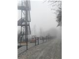
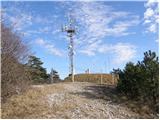
 | Zlogonje - Vidikovac Vukovoj
Vidikovac Vukovoj is located on the eastern part of Ravna Gora. Built in 2025, it quickly became extremely popular among visitors and hikers from...
45 min |
 | Brezje pri Dobrovi - Vrhovčev grič (via Strmca)
Vrhovčev grič is an indistinct, forested peak located just a few meters off the marked trail between Debeli hrib and Strmca....
45 min |
 | Ruše - Kluže
Kluže (also Kluža) is a 496-meter-high hill situated between the right bank of the Drava and the left bank of the Lobnica. A short unmarked path ...
45 min |
 | Cvetlin - Sveti Avguštin (old pilgrimage path)
Sv. Avguštin is a 504-meter-high hill about 4 km from Leskovec toward the Croatian border. It is the highest peak in this part of the Haloze regi...
50 min |
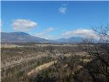
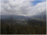
 | Lake Gradišče - Sveti Mohor on Mohorjev hrib (via Prikrnica)
The church of St. Mohor is situated on a panoramic rise, the lower peak of Mohorjev hrib above Moravče. From the top, a beautiful view opens up t...
1 h 5 min |
 | Lake Gradišče - Sveti Mohor on Mohorjev hrib
The church of St. Mohor is situated on a panoramic rise, the lower peak of Mohorjev hrib above Moravče. From the top, a beautiful view opens up t...
50 min |
 | Sveti Mihovil (nad Komižo) - Mali Hum
Mali Hum is located on the island of Vis above the town of Komiža. A cairn marks the summit. Fine views extend to Hum, Komiža, and the nearby isl...
50 min |
 | Globoko - Ojstra peč (via Zjavka)
Ojstra peč is a panoramic rocky promontory between the Lipniška Valley and the Sava River valley at Globoko, dropping steeply toward the fields a...
40 min |
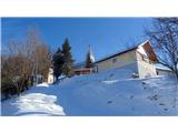
 | Hraše - Smledniški hrib (Stari grad)
Stari grad (also known as Smlednik Castle) is located on a small hill southwest of Valburga. In recent years, the castle has been renovated and n...
45 min |
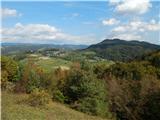
 | Temnica - Sveti Ambrož (Tabor) (western path)
Sveti Ambrož (or Tabor) is a hill on the Karst above the villages of Temnica and Lipa. On the summit are the remains of the former St. Ambrož Chu...
45 min |
| Temnica - Sveti Ambrož (Tabor) (northern path)
Sveti Ambrož (or Tabor) is a hill on the Karst above the villages of Temnica and Lipa. On the summit are the remains of the former St. Ambrož Chu...
50 min |
 | Buzet Railway Station - Kuk (above Buzet)
Kuk is a grassy peak above Buzet. It is located on the edge of the cliff above Buzet Railway Station. From the summit, a beautiful view opens up ...
35 min |
 | Dragomer - Vrh (Debeli hrib)
Vrh is a 540-meter-high hill on the Debeli hrib ridge, which lies between the Ljubljana Marshes and the Horjulščica river valley. The view from t...
40 min |
 | Church of St. Lovrenc above Dragomer - Vrh (Debeli hrib) (via Vrhovčev grič)
Vrh is a 540-meter-high hill on the Debeli hrib ridge, which lies between the Ljubljana Marshes and the Horjulščica river valley. The view from t...
45 min |
 | Vrzdenec - Gradišče above Žažar (via Žažar)
Gradišče above Žažar is a panoramic peak topped by a large wooden cross. From the summit, which also has a summit logbook with a stamp, there is ...
1 h |
| Vrzdenec - Gradišče above Žažar (via Plesa)
Gradišče above Žažar is a panoramic peak topped by a large wooden cross. From the summit, which also has a summit logbook with a stamp, there is ...
45 min |
 | Želimlje - Castle Stari grad above Želimlje
Stari grad above Želimlje is a forest-covered peak located between Želimlje and Rogatec above Želimlje....
50 min |
 | Bad Gleichenberg (Eichgraben Weg) - Bschaidkogel (via Mühlsteinbruch)
Bschaidkogel is a 563-meter-high mountain located northeast of the town of Bad Gleichenberg....
50 min |
 | Sežana - Zidovnik (Sedovnik) (by road)
Zidovnik is a 575-meter-high peak located west of Sežana. From the summit, which hosts a few transmitters, the view is limited by the forest and ...
1 h |
 | Kamnik - Castle Stari grad Kamnik (by road)
Stari grad Kamnik, formerly known as Zgornji grad (Oberstain), is located on a scenic hill east of Kamnik called Krniška gora. Today, only ruins ...
1 h |
 | Radovljica - Lipnica Castle (Pusti grad above Lipnica) (via Ravnica)
Lipniški Castle, or Pusti grad above Lipnica (German: Waldenberg), is located on a panoramic hill above the Sava and Lipnica watercourses, more p...
1 h 5 min |
| Zgornja Dobrava - Lipnica Castle (Pusti grad above Lipnica) (via Ojstra peč)
Lipniški Castle, or Pusti grad above Lipnica (German: Waldenberg), is located on a panoramic hill above the Sava and Lipnica watercourses, more p...
1 h 5 min |
 | Zgornje Poljčane - Baba (at Boč)
Baba is a 594-meter-high forested peak located near two marked paths on Boč, with only two unmarked footpaths leading to the summit....
35 min |
| Zgornje Poljčane - Baba (at Boč) (Detičkova pot)
Baba is a 594-meter-high forested peak located near two marked paths on Boč, with only two unmarked footpaths leading to the summit....
40 min |
 | Sveta Barbara (Nova Hrastnica) - Sveti Andrej (above Zminec)
The Church of St. Andrew is located on a panoramic hill in the Sveti Andrej settlement. From the church, there is a fine view of the Škofjeloško ...
50 min |
 | Kranj-Stražišče (Šrotenturn) - Šmarjetna gora (west path)
Šmarjetna gora is a panoramic peak rising above Kranj. From the summit, where the Church of St. Margaret and the Hotel Bellevue stand, a beautifu...
40 min |
 | Lovrenc na Pohorju (cemetery) - Koglerjev vrh
Koglerjev vrh is a 698-meter-high forested peak located southwest of the organic farm Šlaus-Kogler, which lies above the settlement of Lovrenc na...
45 min |
| Lovrenc na Pohorju (cemetery) - Koglerjev vrh (via Hožičev vrh)
Koglerjev vrh is a 698-meter-high forested peak located southwest of the organic farm Šlaus-Kogler, which lies above the settlement of Lovrenc na...
1 h |
 | Zgornja Besnica (Nova vas) - Rovnik (west path)
Rovnik is a 707-meter-high peak located west of Zgornja Besnica. The summit features two benches, a wish bell, and a logbook box, but offers no v...
40 min |
 | Zgornja Besnica (Nova vas) - Rovnik (east path)
Rovnik is a 707-meter-high peak located west of Zgornja Besnica. The summit features two benches, a wish bell, and a logbook box, but offers no v...
45 min |
 | Parje - Primož
Primož is a 718-meter-high peak located south to southeast of Pivka. Due to its ideal location overlooking the entire Pivka Basin, the Italians b...
40 min |