 | Jevnica - Janče
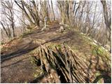
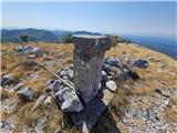
Janče is a 792-meter-high peak situated between the Sava River and the Besnica stream valley. From the summit, where a mountain hut stands and th...
1 h 45 min |
 | Breg (Liški potok) - Lisca
Lisca is a panoramic peak located north of Sevnica. From the summit, where a meteorological radar station stands, there are fine views of Posavsk...
2 h 5 min |
| Krakovo (Mastnak wine cellar) - Lisca (via Skalce)
Lisca is a panoramic peak located north of Sevnica. From the summit, where a meteorological radar station stands, there are fine views of Posavsk...
1 h 50 min |
| Krakovo (Mastnak wine cellar) - Lisca (Pastirčkova pot)
Lisca is a panoramic peak located north of Sevnica. From the summit, where a meteorological radar station stands, there are fine views of Posavsk...
1 h 55 min |
| Krakovo (Mastnak wine cellar) - Lisca (past Sveti Jošt)
Lisca is a panoramic peak located north of Sevnica. From the summit, where a meteorological radar station stands, there are fine views of Posavsk...
1 h 55 min |
 | Breg - Sveti Lovrenc (above Okroglice)
The Church of St. Lovrenc is located east of Zidani Most and northwest of Sevnica, above the village of Okroglice and near the Lovrenc peak. From...
1 h 45 min |
| Dolina Gračnice (Blatnik) - Sveti Lovrenc (above Okroglice)
The Church of St. Lovrenc is located east of Zidani Most and northwest of Sevnica, above the village of Okroglice and near the Lovrenc peak. From...
1 h 45 min |
 | Rimske Toplice - Dom v Gorah (via Ogeški potok)
The Dom v Gorah mountain hut is located east of Hrastnik, just a few meters below the 786 m high peak where the church of St. Jurij stands. From ...
2 h 40 min |
| Rimske Toplice (Šmarjeta) - Dom v Gorah (via Lurd)
The Dom v Gorah mountain hut is located east of Hrastnik, just a few meters below the 786 m high peak where the church of St. Jurij stands. From ...
2 h 40 min |
 | Laško - Dom na Šmohorju
The mountain lodge on Šmohor is located on a picturesque and scenic ridge between Laško, Liboje and Zabukovica. The lodge, a popular spot for bot...
2 h |
 | Tremerje - Dom na Šmohorju
The mountain lodge on Šmohor is located on a picturesque and scenic ridge between Laško, Liboje and Zabukovica. The lodge, a popular spot for bot...
2 h 15 min |
 | Laško - Malič
Malič is a 936-meter-high peak situated between Celje and Laško, more precisely above Spodnja Rečica. From the summit, which has a transmitter, b...
2 h 15 min |
 | Tremerje - Malič (on western ridge of Malič)
Malič is a 936-meter-high peak situated between Celje and Laško, more precisely above Spodnja Rečica. From the summit, which has a transmitter, b...
2 h |
 | Gradišče pri Vipavi - Gradiška Tura (via Plaz)
Gradiška Tura is a prominent 754-meter peak rising at the far western edge of the Nanos plateau directly above the Vipava Valley. Thanks to its e...
2 h |
 | Štore - Resevna
Resevna is a peak situated south of Šentjur. At the summit stands a 20-meter-high observation tower offering beautiful views that extend far acro...
2 h 30 min |
 | Zagrad - Tolsti vrh above Celjska koča (eastern way)
Tolsti vrh (also recorded as Tovsti vrh in some sources) is situated above the Celjska koča ski area. The summit has a logbook box and stamp, but...
1 h 45 min |
 | Štore - Tolsti vrh above Celjska koča (via Žlajfa)
Tolsti vrh (also recorded as Tovsti vrh in some sources) is situated above the Celjska koča ski area. The summit has a logbook box and stamp, but...
2 h 15 min |
 | Štore - Tolsti vrh above Celjska koča (via Bojanski graben)
Tolsti vrh (also recorded as Tovsti vrh in some sources) is situated above the Celjska koča ski area. The summit has a logbook box and stamp, but...
2 h 30 min |
 | Štore - Tolsti vrh above Celjska koča (via Marija)
Tolsti vrh (also recorded as Tovsti vrh in some sources) is situated above the Celjska koča ski area. The summit has a logbook box and stamp, but...
2 h |
 | Teharje - Tolsti vrh above Celjska koča (via Srebotnik on CPP)
Tolsti vrh (also recorded as Tovsti vrh in some sources) is situated above the Celjska koča ski area. The summit has a logbook box and stamp, but...
3 h |
 | Štore - Srebotnik (via Marija and south approach)
Srebotnik is a slightly vegetated peak located south of Celje and Štore in the Posavsko hribovje. The summit, which has a logbook box and a small...
1 h 45 min |
 | Teharje - Srebotnik (Pot I. Celjske čete)
Srebotnik is a slightly vegetated peak located south of Celje and Štore in the Posavsko hribovje. The summit, which has a logbook box and a small...
2 h |
 | Podgozd - Sveti Peter
Sveti Peter is a partly forested peak in Suha Krajina above the village of Dvor. On the summit stands a small shelter (usually open on Sundays) a...
1 h 50 min |
 | Podsreda - Veliki Špiček (through Osredek pri Podsredi)
Veliki Špiček is the highest peak of Brežice municipality. From the top a nice view spreads towards the south and east. Most of Brežice municipal...
2 h 45 min |
 | Zidani Most - Nebeška gora (eastern path)
Nebeška gora is the highest peak of the Radeče ob Savi municipality. At the summit there is a logbook, stamp, luck bell, and some benchesall plac...
2 h 40 min |
| Zidani Most - Nebeška gora (western path)
Nebeška gora is the highest peak of the Radeče ob Savi municipality. At the summit there is a logbook, stamp, luck bell, and some benchesall plac...
2 h 45 min |
 | Laško (cemetery Laško) - Govško brdo
Govško brdo is an 811-meter-high hill located west of the village of Huda Jama above Laško. From the summit, which features a logbook box and sta...
2 h 35 min |
 | Štore - Veliki vrh above Svetina (via Marija and over Svetina)
Veliki vrh lies southwest of the settlement of Svetina above Štore. It is settled high up mainly from the south side, with one homestead directly...
2 h 30 min |
 | Štore - Veliki vrh above Svetina (via Žlajfa and via Svetina)
Veliki vrh lies southwest of the settlement of Svetina above Štore. It is settled high up mainly from the south side, with one homestead directly...
2 h 15 min |
 | Štore - Veliki vrh above Svetina (through Bojanski graben and over Svetina)
Veliki vrh lies southwest of the settlement of Svetina above Štore. It is settled high up mainly from the south side, with one homestead directly...
2 h 30 min |
 | Studenice - Plešivec (at Boč)
Peace, silence, varied terrain... these are characteristics of the peak at the crossroads of numerous paths between the Maribor, Celje, and Ptuj ...
2 h |
 | Studenice - Plešivec (at Boč) (final part on forest road)
Peace, silence, varied terrain... these are characteristics of the peak at the crossroads of numerous paths between the Maribor, Celje, and Ptuj ...
2 h |
 | Zvekovica - Stražišće (by road)
Stražišće is a peak rising above Cavtat, offering a magnificent view of Cavtat, Konavle and Dubrovnik.A cross stands on the summit in memory of t...
2 h |
 | Rimske Toplice - Vrhe (at Gore) (via Ogeški potok)
Vrhe is a forested 781-meter-high peak located northwest of the Planinski dom hut in Gore....
2 h 50 min |
| Rimske Toplice (Šmarjeta) - Vrhe (at Gore) (via Lurd)
Vrhe is a forested 781-meter-high peak located northwest of the Planinski dom hut in Gore....
2 h 50 min |
 | Spodnje Tinsko - Plešivec (Rudnica)
Plešivec is a forest-covered peak on Rudnica, its highest point. The summit has a summit register box, a bench, and a table....
1 h 45 min |
| Slake (Church of the Virgin Mary on Pesek) - Plešivec (Rudnica)
Plešivec is a forest-covered peak on Rudnica, its highest point. The summit has a summit register box, a bench, and a table....
2 h |
| Podčetrtek (sveti Lovrenc) - Plešivec (Rudnica)
Plešivec is a forest-covered peak on Rudnica, its highest point. The summit has a summit register box, a bench, and a table....
1 h 50 min |
| Podčetrtek (Terme Olimia) - Plešivec (Rudnica) (past castle Podčetrtek)
Plešivec is a forest-covered peak on Rudnica, its highest point. The summit has a summit register box, a bench, and a table....
2 h 5 min |
 | Pásztó - Muzsla (path marked with green plus)
Muzsla (Mužlo) is the highest peak in the western part of the Mátra Mountains, which also include Hungary's highest peak Kékestető. A concrete to...
3 h 15 min |
 | Majkovi - Neprobić
Neprobić is a panoramic peak above Slano, near the border with Bosnia and Herzegovina. The summit has a geodetic marker and is an HPO point. From...
3 h |
 | Mošćenice - Kremenjak (past Kalvarija)
Kremenjak is a scenic rocky peak on Učka. The peak is a point on the Istrian Mountain Path. From the peak, which has a summit book box and a bord...
2 h 45 min |
| Mošćenice - Kremenjak (on marked path)
Kremenjak is a scenic rocky peak on Učka. The peak is a point on the Istrian Mountain Path. From the peak, which has a summit book box and a bord...
2 h 40 min |
 | Mošćenice - Planinsko zavetišče Kremenjak (past Kalvarija)
The Kremenjak Mountain Shelter is located on a small peak between Kremenjak and Brgud. The bivouac is of quite unusual shape and has some benches...
2 h 45 min |
| Mošćenice - Planinsko zavetišče Kremenjak (on marked path)
The Kremenjak Mountain Shelter is located on a small peak between Kremenjak and Brgud. The bivouac is of quite unusual shape and has some benches...
2 h 40 min |
 | Mošćenice - Brgud (past Kalvarija and Kremenjak)
Brgud is a scenic peak on Učka. The peak is a point of the Istrian Mountain Path. At the highest point of the peak, there is only a pile of stone...
3 h 15 min |
| Mošćenice - Brgud (along the marked trail and past Kremenjak)
Brgud is a scenic peak on Učka. The peak is a point of the Istrian Mountain Path. At the highest point of the peak, there is only a pile of stone...
3 h 10 min |
 | Podsreda - Veliki vrh (Orlica) (through Osredek pri Podsredi)
Veliki vrh is the highest point of the Orlica hills at 701 meters above sea level, stretching along the border between Posavje and Kozjansko and ...
1 h 45 min |
| Pišece (Pri mlinu) - Veliki vrh (Orlica)
Veliki vrh is the highest point of the Orlica hills at 701 meters above sea level, stretching along the border between Posavje and Kozjansko and ...
2 h 40 min |
 | Podsreda - Intermedija (through Osredek pri Podsredi)
Intermedija is a 662-meter-high peak in the Orlica range. From the summit, there is a beautiful view mainly to the north and northeast, where on ...
2 h 20 min |
| Pišece (Pri mlinu) - Intermedija
Intermedija is a 662-meter-high peak in the Orlica range. From the summit, there is a beautiful view mainly to the north and northeast, where on ...
1 h 50 min |