 | Aljažev dom v Vratih - Dolkova špica (western way)
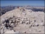
Dolkova špica is a 2,591 m high mountain situated between Stenar and Škrlatica. From the summit, which has a registration box, a beautiful panora...
5 h 15 min |
| Zadnjica - Dolkova špica
Dolkova špica is a 2,591 m high mountain situated between Stenar and Škrlatica. From the summit, which has a registration box, a beautiful panora...
7 h 5 min |
 | Zadnjica - Kanjavec (via Dolič)
Kanjavec is a 2,569-meter-high mountain located between Dolič and Hribarice. From the summit, which has a logbook box and a stamp, a beautiful vi...
6 h 35 min |
 | Koča pri Savici - Kanjavec (via Triglavska jezera)
Kanjavec is a 2,569-meter-high mountain located between Dolič and Hribarice. From the summit, which has a logbook box and a stamp, a beautiful vi...
6 h 30 min |
| Aljažev dom v Vratih - Kanjavec
Kanjavec is a 2,569-meter-high mountain located between Dolič and Hribarice. From the summit, which has a logbook box and a stamp, a beautiful vi...
7 h |
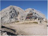 | Zadnjica - Triglavski dom na Kredarici
The Triglav Hut at Kredarica is the highest-lying serviced Slovenian mountain hut. It is open all year round but outside the season only on an em...
7 h 30 min |
 | Uskovnica (Lom) - Triglavski dom na Kredarici (via Planina Spodnji Tosc)
The Triglav Hut at Kredarica is the highest-lying serviced Slovenian mountain hut. It is open all year round but outside the season only on an em...
5 h 35 min |
 | V Koncu - Skuta (via Kokrsko sedlo)
Skuta is a 2,532-meter-high mountain located in the heart of the Kamnik-Savinja Alps. From the summit, which has a logbook box and a stamp, a bea...
5 h 30 min |
| Suhadolnik - Skuta (via Kokrsko sedlo)
Skuta is a 2,532-meter-high mountain located in the heart of the Kamnik-Savinja Alps. From the summit, which has a logbook box and a stamp, a bea...
5 h 45 min |
 | Gozdec - Prestreljenik (via dom Petra Skalarja)
Prestreljenik is a 2,499 m high mountain located in the heart of the Kanin range. From the summit, where there is a registration box shaped like ...
5 h 45 min |
 | Robanov kot - Ojstrica (via Mala Ojstrica)
Ojstrica, named for its sharp shape, rises steeply above Korošica, the Logarska Dolina valley, and Robanov Kot. From the summit, which has a regi...
5 h 15 min |
 | Robanov kot - Ojstrica (via Kocbekov dom)
Ojstrica, named for its sharp shape, rises steeply above Korošica, the Logarska Dolina valley, and Robanov Kot. From the summit, which has a regi...
5 h 45 min |
 | Tolminske Ravne - Krn
Krn, at 2244 m, is the highest peak of the Krn mountain group, which rises steeply above the central part of the Soča River. From the summit, fea...
7 h 30 min |
 | Koča pri Savici - Tolminski Kuk (via Vrh Planje)
Tolminski Kuk is the highest peak in the Bohinj-Tolmin mountains. The summit, equipped with a registration box, offers a very beautiful view. Fro...
6 h |
 | The Kot Valley - Cmir
Cmir is located between two alpine valleys: Vrata and the lesser-known valley Za Cmirom. From the summit, there is a beautiful view of the peaks ...
6 h 10 min |
| Dolina Krma - Cmir
Cmir is located between two alpine valleys: Vrata and the lesser-known valley Za Cmirom. From the summit, there is a beautiful view of the peaks ...
7 h 15 min |
 | Zadnjica - Križ (via Dovška vrata)
Križ is a 2,140 m high mountain located northeast of the Kriški Podi plateau. The summit, which has a registration box with a stamp, offers a bea...
5 h 45 min |
 | Tolminske Ravne - Batognica
Batognica is a 2164 m high mountain that was the site of the so-called mine warfare during World War I. Remnants of the fighting between Italian ...
6 h 45 min |
 | Zadnjica - Planja
The Planja summit is located between two alpine valleys: Mlinarica on the north side and Zadnjica on the south. From the summit, there is a beaut...
5 h 45 min |
| Aljažev dom v Vratih - Planja (via Sovatna)
The Planja summit is located between two alpine valleys: Mlinarica on the north side and Zadnjica on the south. From the summit, there is a beaut...
6 h 5 min |
 | Koča pri Savici - Veliko Špičje
Veliko Špičje is the highest peak in the ridge from Travnik to Zasavska koča. From the top, there is a very nice view of the Komna plateaus, the ...
5 h 40 min |
| Koča pri Savici - Veliko Špičje (via Zasavska koča)
Veliko Špičje is the highest peak in the ridge from Travnik to Zasavska koča. From the top, there is a very nice view of the Komna plateaus, the ...
7 h 15 min |
| Zadnjica - Veliko Špičje
Veliko Špičje is the highest peak in the ridge from Travnik to Zasavska koča. From the top, there is a very nice view of the Komna plateaus, the ...
6 h 20 min |
| Trenta - Veliko Špičje
Veliko Špičje is the highest peak in the ridge from Travnik to Zasavska koča. From the top, there is a very nice view of the Komna plateaus, the ...
6 h 30 min |
 | Koča pri Savici - Mala Zelnarica (via Štapce)
Mala Zelnarica is a 2310-meter-high peak situated between the Valley of the Triglav Lakes and the Za Kopico Valley. From the summit, which has a ...
5 h 55 min |
 | Koča pri Savici - Mala Zelnarica (via Vrata)
Mala Zelnarica is a 2310-meter-high peak situated between the Valley of the Triglav Lakes and the Za Kopico Valley. From the summit, which has a ...
6 h 40 min |
 | Zadnjica - Bovški Gamsovec (via Luknja)
Bovški Gamsovec is a 2392 m high mountain in the immediate vicinity of Triglav. From the summit there is a magnificent view of Triglav and its no...
5 h 15 min |
| Zadnjica - Bovški Gamsovec (via Dovška vrata)
Bovški Gamsovec is a 2392 m high mountain in the immediate vicinity of Triglav. From the summit there is a magnificent view of Triglav and its no...
5 h 30 min |
 | Reklanska dolina - Sart / Žrd
Žrd, or Monte Sart in Italian, is a panoramic mountain located on the northwestern ridge of the Kanin mountains. The summit, which has a logbook ...
5 h 15 min |
 | Aljažev dom v Vratih - Pihavec (via Sovatna)
Pihavec is a spacious and panoramic peak located south of Kriški Podi. From the summit, which has a logbook and stamp, there are nice views of mo...
5 h 15 min |
| Zadnjica - Pihavec
Pihavec is a spacious and panoramic peak located south of Kriški Podi. From the summit, which has a logbook and stamp, there are nice views of mo...
5 h 15 min |
 | Unterpirkach - Hochstadel (Dreitörlweg)
Hochstadel is a 2,681-meter peak in the eastern part of the picturesque Lienz Dolomites. From the summit, where a large cross commemorates those ...
6 h 50 min |
 | Hinterstoder - Großer Priel
Großer Priel, at 2515 meters, is the highest peak in the Totes Gebirge mountain group. From the summit, where a large red cross stands, there is ...
5 h 15 min |
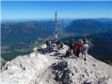 | Parking Alpspitzbahn - Alpspitze (Ostgrat)
Alpspitze is a 2628-meter-high peak in the Wetterstein mountain group. From the summit, where a cross from 1946 stands, there is a very nice view...
6 h 15 min |
 | Parking Alpspitzbahn - Bernadeinkopf (via Osterfelderkopf)
Bernadeinkopf is a 2143-meter-high peak in the Wetterstein mountain group. From the summit, where a cross stands, there is a very nice view of th...
5 h 30 min |