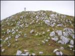
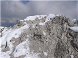
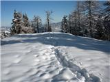
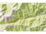
 | Podljubelj (Lajb) - Begunjščica
Begunjščica is a mountain range in the Karawanks east of Stol. Its highest peak is Veliki Vrh, which at over 2,000 m offers a fine view across ce...
3 h 30 min |
 | Dom v Dragi - Begunjščica (via Preval-a)
Begunjščica is a mountain range in the Karawanks east of Stol. Its highest peak is Veliki Vrh, which at over 2,000 m offers a fine view across ce...
3 h 30 min |
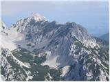
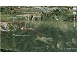
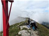
 | Vranček - Loibler Baba/Košutica (western way)
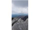
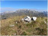
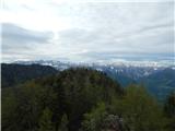
Košutica (also known as Ljubeljska Baba) is a panoramic mountain north of the western ridge of Košuta. From the summit, marked by a small cross a...
2 h 50 min |
 | Kokra (Roblek) - Kalška gora (via Kalce)
Kalška gora lies between the Kalški greben and Kokrsko sedlo. From the grassy summit there is a beautiful view towards the nearby Kalški greben. ...
4 h 30 min |
 | Podljubelj (Lajb) - Dobrča
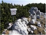
Dobrča is a 1634-metre mountain located between Begunje and Tržič. From the summit, which has a registration box with a stamp, the view opens onl...
4 h 30 min |
 | Aljažev dom v Vratih - Pogačnikov dom na Kriških podih (via Sovatna)
The hut is located on the scenic ridge Griva on Kriški Podi above Trenta. The hut, open during the summer season, also has a large winter room. T...
4 h 30 min |
 | Rosenbach - Kahlkogel/Golica (via Medji dol)
Golica is an unvegetated peak located north of Jesenice. From the summit, where a registration box is placed, there is a fine view of the western...
3 h 45 min |
| Rosenbach - Kahlkogel/Golica (via Quadiaalm)
Golica is an unvegetated peak located north of Jesenice. From the summit, where a registration box is placed, there is a fine view of the western...
3 h 35 min |
| Tallach - Kahlkogel/Golica (via Quadiaalm)
Golica is an unvegetated peak located north of Jesenice. From the summit, where a registration box is placed, there is a fine view of the western...
3 h 50 min |
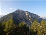
 | Povlje - Bašeljski vrh
Bašeljski vrh is a 1744-meter-high mountain located between Mali Grintovec and Storžič. From the summit, where there is a bench and a registratio...
3 h 50 min |
| Laško - Bašeljski vrh (via Sveti Lovrenc)
Bašeljski vrh is a 1744-meter-high mountain located between Mali Grintovec and Storžič. From the summit, where there is a bench and a registratio...
3 h 40 min |
| Bašelj - Bašeljski vrh (via Sveti Lovrenc)
Bašeljski vrh is a 1744-meter-high mountain located between Mali Grintovec and Storžič. From the summit, where there is a bench and a registratio...
4 h 15 min |
 | Kanonir - Kozji vrh
Kozji vrh lies northeast of Storžič and, thanks to its unvegetated summit, offers a beautiful view of all the mountains around Jezersko. Storžič,...
2 h 30 min |
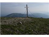
 | Kokra (Roblek) - Vrh Korena
Vrh Korena is located between Zvoh and Kalški greben near the Krvavec ski resort. The summit offers a beautiful view of the highest peaks in the ...
3 h |
 | Koča pri Savici - Bogatin (via Bogatinsko sedlo)
Bogatin, also known as Mali Bogatin, is the last or first peak in the chain of the Lower Bohinj Mountains. From the summit, where there is a summ...
4 h 30 min |
| Dom v Lepeni - Bogatin (via Bogatinsko sedlo)
Bogatin, also known as Mali Bogatin, is the last or first peak in the chain of the Lower Bohinj Mountains. From the summit, where there is a summ...
4 h 30 min |
 | Velacher Kotschna/Belska Kočna - Ledinski vrh
The mountain is located above Jezersko and lies on the border with Austria. From the summit there is a beautiful view north towards the neighbour...
3 h 45 min |
 | Matizovec - Kofce gora
Kofce gora is a 1967 m high peak located in the eastern part of the longest Slovenian ridge. From the summit, which drops precipitously towards A...
2 h 35 min |
| Dolina - Kofce gora (past the chapel)
Kofce gora is a 1967 m high peak located in the eastern part of the longest Slovenian ridge. From the summit, which drops precipitously towards A...
2 h 50 min |
| Dolina - Kofce gora
Kofce gora is a 1967 m high peak located in the eastern part of the longest Slovenian ridge. From the summit, which drops precipitously towards A...
2 h 45 min |
 | Matizovec - Veliko Kladivo
Veliko Kladivo is a 2094 m high peak in the longest Slovenian ridge, Košuta. From the summit, which has a register box and stamp, there is a very...
3 h 20 min |
| Dolina - Veliko Kladivo
Veliko Kladivo is a 2094 m high peak in the longest Slovenian ridge, Košuta. From the summit, which has a register box and stamp, there is a very...
3 h 30 min |
 | Laško - Mali Grintovec (via Sveti Lovrenc)
Mali Grintovec is a panoramic mountain located east of Storžič. From the summit, which has a summit register box, stamp, and a pleasant bench, th...
4 h 25 min |
| Povlje - Mali Grintovec
Mali Grintovec is a panoramic mountain located east of Storžič. From the summit, which has a summit register box, stamp, and a pleasant bench, th...
4 h 25 min |
 | Dol - Stegovnik (via Močnikovo sedlo)
Stegovnik (also Štegovnik) is a scenic ridge mountain between the valley of Tržiška Bistrica and Kokra. From the summit, there is a very nice vie...
2 h 30 min |
 | Markova raven - Košutna (marked way)
The summit is located between Kompotela and the mountain pasture Košutna. From the top, there is a beautiful view toward Krvavec and Kalški grebe...
2 h 50 min |
 | Matizovec - Malo Kladivo
Malo Kladivo is located in the Košuta ridge. From the summit, which has no registration box, there is a nice view toward the neighboring Veliko K...
3 h 5 min |
 | Žabnice/Camporosso in Valcanale - Kamniti lovec / Cima del Cacciatore
Kamniti lovec is a popular excursion point above Trbiž. Due to the short approach, shortened by the cable car to Višarje, it is well visited. Two...
3 h 15 min |
 | Gostišče Firšt - Govca (Olševa)
Govca is the highest peak of the Olševa range, rising above Koprivna, Solčava, and Remšenik (Remšenik/Remschenig is a valley on the Austrian side...
3 h 45 min |
 | Tolminske Ravne - Vrh nad Škrbino (on mule track and direct way)
Vrh nad Škrbino is the easternmost two-thousander in the ridge of the Lower Bohinj Mountains. From the summit, there are excellent views of the n...
4 h |
 | Breginj - Stol (Julian Alps)
Stol (1673 m) is located in the longest ridge of the Julian Alps. The ridge measures 25 km, or 35 km if including the western part. From the summ...
3 h 10 min |
 | Breginj - Muzec - Musc (Mali Muzec)
Muzec or Musc (also Mali Muzec on maps) is a 1,612 m high mountain located north of Breginjski kot. From the summit, where there is a logbook box...
2 h 55 min |
 | Crni Lug - Veliki Risnjak (Horvatova staza)
Veliki Risnjak, at 1528 m, is the highest peak of Risnjak National Park. From the summit, which has a logbook box and stamp, there is a very nice...
3 h 30 min |
 | Remšendol - Šober / Monte Sciober Grande (via 518)
Šober / Monte Sciober Grande is a 1,845 m high peak located between the Remšendol Valley and Jezerska Valley. From the summit there is a fine vie...
3 h |
 | Breginj - Gabrovec (Veliki Muzec)
Gabrovec (also Veliki Muzec on maps) is a 1630-meter-high mountain located northwest of Breginj, Slovenia's westernmost village. From the summit,...
3 h |
 | Vranček - Lokovnikov Grintovec / Grintoutz
Lokovnikov Grintovec is a dwarf pine-covered peak north of Košutica, separated from it by Dovjakovo sedlo saddle (1,728 m). Its southwestern and ...
2 h 50 min |
| Sele-Zvrhnji Kot (Male) / Zell-Oberwinkel (Male) - Lokovnikov Grintovec / Grintoutz
Lokovnikov Grintovec is a dwarf pine-covered peak north of Košutica, separated from it by Dovjakovo sedlo saddle (1,728 m). Its southwestern and ...
4 h |
 | Tolminske Ravne - Zeleni vrh (via Dolina pod Ploščo)
Zeleni vrh is a 2052-meter-high mountain located east of the highest peak of the Spodnje Bohinjske gore. From the grassy summit, which drops prec...
4 h 10 min |
 | Čadrg - Tolminski Migovec
Tolminski Migovec is a 1881 m high mountain. Its western slope above the Tolminka valley is the steepest and most scenic. The southern slope is i...
3 h 30 min |
 | Bajdiše (Gozdar) / Waidisch (forsthaus) - Matzen
Macna / Matzen is a 1627-meter-high peak located north of Košuta and south of the Drava River. From Macna, there is a fine view of the nearby Obi...
3 h |
 | Breginj - Nizki vrh
Nizki vrh is located at the crossroads between Breški Jalovec / Monte Maggiore (ITA) and Gabrovec near the state border; from the summit a beauti...
3 h |
 | Pala Barzana - Monte Raut (CAI 967)
Raut is a 2,025 m high limestone vantage point above the Friulian plain and the second-highest peak of the ridge between lakes Barcis and Selva. ...
3 h 45 min |
 | Bajdiše / Waidisch - Borovski vrh (Žehtar) / Sechter
Borovski vrh (Žehtar) / Sechter is a 1,449-meter-high peak located between Grlovec / Ferlacher Horn and Borovlje / Ferlach. From the summit, wher...
3 h |
 | Niederalpl Ort - Hohe Veitsch (through Rodel valley)
Hohe Veitsch is the highest peak of the Veitsch mountain range, located in the eastern part of the Northern Limestone Alps. From the summit, a be...
2 h 40 min |
 | parking lot Hoyer (Neuhofgraben) - Speikkogel (Gleinalpe)
Speikkogel lies northwest of Graz and, at 1988 m, is the second highest peak of the Gleinalpe.The European path E6 and the Austrian Central Alpin...
3 h 30 min |
 | parking lot Hoyer (Neuhofgraben) - Lenzmoarkogel (Gleinalpe)
Lenzmoarkogel is located northwest of Gradec and, at 1991 meters above sea level, is the highest peak of the Gleinalpe (Glinska planina).The thre...
3 h 45 min |
 | parking lot Hoyer (Neuhofgraben) - Lärchkogel (Gleinalpe) (via Speikkogel)
Lärchkogel is a 1,894-meter peak in the Gleinalpe massif with a cross and a small shelter beside it. From the summit, there are fine views of Spe...
4 h 15 min |
 | Passo Tanamea - Monte Zajavor
Zajavor (Italian: Monte Zajavor or Monte Zaiavor) is a 1,815-meter-high peak in the eastern, grassier part of the Muzci ridge. From the summit, w...
3 h |