 | Dragomer (bajer) - Vrhovčev grič (via Ferjanka and Strmca)
Vrhovčev grič is an indistinct, forested peak located just a few meters off the marked trail between Debeli hrib and Strmca....
1 h 10 min |
 | Komare doline - Kuk
Kuk (also known as Ščukovec on some maps) is a 498-meter-high hill north of the village Movraž. From the summit, which features a small cross, th...
1 h 15 min |
 | Komare doline - Veliki Gradež
Veliki Gradež is a 507-meter-high rise between Zazid and Movraž. From the summit, amid expansive pastures, there is a fine view of the Primorska ...
1 h 30 min |
 | Lake Gradišče - Sveti Mohor on Mohorjev hrib (via Vinje pri Moravčah)
The church of St. Mohor is situated on a panoramic rise, the lower peak of Mohorjev hrib above Moravče. From the top, a beautiful view opens up t...
1 h 35 min |
 | Skaručna - Smledniški hrib (Stari grad) (via Zapoški hrib)
Stari grad (also known as Smlednik Castle) is located on a small hill southwest of Valburga. In recent years, the castle has been renovated and n...
1 h 40 min |
 | Repnje - Smledniški hrib (Stari grad)
Stari grad (also known as Smlednik Castle) is located on a small hill southwest of Valburga. In recent years, the castle has been renovated and n...
1 h 15 min |
 | Rdeči Kal - Ostri vrh (above Globodol) (via Velika raven)
Ostri vrh is a 523-meter-high peak located between Vrbovec, Rdeči Kal, Gorenji, Srednji, and Dolenji Globodol, Dolnji and Gornji Ajdovec, and Pod...
1 h 15 min |
| Dom Frata - Ostri vrh (above Globodol)
Ostri vrh is a 523-meter-high peak located between Vrbovec, Rdeči Kal, Gorenji, Srednji, and Dolenji Globodol, Dolnji and Gornji Ajdovec, and Pod...
1 h 20 min |
 | Liboje - Kamčič (via organic farm Kralj - southern approach)
Kamčič is a wooded peak in the Posavje Hills, located north of Šmohor between Kotečnik to the left and Veliki Slomnik to the right. It is recogni...
1 h 10 min |
 | Gorjuša - Sveta Trojica (above Dob) (via Dobovlje)
Sveta Trojica is a village located southeast of Dob pri Domžalah. In the upper part of the village, on a scenic hill, stands the Church of the Ho...
1 h 50 min |
 | Zgornje Poljčane - Ljubična gora
Ljubična gora is an elongated hill above the settlements of Ljubično, Zbelovo and Zbelovska gora. The peak is hidden in forest and not well visib...
1 h 15 min |
| Zgornje Poljčane - Ljubična gora (po Jakobovi poti)
Ljubična gora is an elongated hill above the settlements of Ljubično, Zbelovo and Zbelovska gora. The peak is hidden in forest and not well visib...
1 h 15 min |
 | Velika Kostrevnica - Kožljevec
Kožljevec (also Kožlevec) is a 533-meter-high hill above Cerovica in the municipality of Šmartno pri Litiji. The forested summit features a logbo...
1 h 10 min |
 | Brezje pri Dobrovi - Vrh (Debeli hrib) (via Strmca)
Vrh is a 540-meter-high hill on the Debeli hrib ridge, which lies between the Ljubljana Marshes and the Horjulščica river valley. The view from t...
1 h 15 min |
 | Okrog (Lazar) - Zaplaz
Zaplaz is a 543-meter-high hill located above Čatež, a settlement best known as the endpoint of the Levstik Trail (From Litija to Čatež). The sum...
1 h 10 min |
 | Gaber pri Semiču - Smuk (via Semenič)
Smuk is a 545-meter-high peak above Semič. The summit features the Church of St. Lawrence, a hunting cabin, and nearby ruins of Smuk (or Turn) Ca...
1 h 10 min |
 | Wildon - Buchkogel (Wildoner Berg)
Buchkogel or Wildoner Berg is a 550-meter-high hill in southern Styria. Buchkogel together with the peaks Wildoner Schlossberg (450 m) and Bockbe...
1 h 30 min |
 | Založe (Hotunjščica) - Sevčnik (Andraška pot (pri Vodostečni))
Sevčnik is a hill located northeast of Polzela along the PolzelaVelenje road. The nearest larger settlement is Andraž nad Polzelo. The summit off...
1 h 30 min |
 | Bad Gleichenberg (Eichgraben Weg) - Bschaidkogel (via Steinriegel)
Bschaidkogel is a 563-meter-high mountain located northeast of the town of Bad Gleichenberg....
1 h 30 min |
 | Treskavac - Obzova
Obzova is the highest point on the island of Krk. Like the entire surrounding area, the summit is completely rocky. Interesting are the pools nea...
1 h 30 min |
 | Žička kartuzija - Babček (via crossing Podgranček)
Babček is an indistinct peak on the hiking trail between Konjiška gora and Boč. An asphalt road runs practically right below the summit. There ar...
1 h 10 min |
 | Žička kartuzija - Babček
Babček is an indistinct peak on the hiking trail between Konjiška gora and Boč. An asphalt road runs practically right below the summit. There ar...
1 h 10 min |
 | Šahovec - Trebni vrh (Baragova pot)
Trebni vrh is a 581-meter-high hill located south or southwest of Trebnje. On the forested summit stands a bench, and nearby is a logbook box wit...
1 h 5 min |
 | Radovljica - Lipnica Castle (Pusti grad above Lipnica) (on natural learning trail)
Lipniški Castle, or Pusti grad above Lipnica (German: Waldenberg), is located on a panoramic hill above the Sava and Lipnica watercourses, more p...
1 h 20 min |
 | Bad Gleichenberg (Eichgraben Weg) - Gleichenberger Kogel (via Mühlsteinbruch)
Gleichenberger Kogel is a 598-meter-high mountain of volcanic origin located above Bad Gleichenberg in Styria....
1 h 10 min |
| Bad Gleichenberg (Eichgraben Weg) - Gleichenberger Kogel
Gleichenberger Kogel is a 598-meter-high mountain of volcanic origin located above Bad Gleichenberg in Styria....
1 h 5 min |
| Bad Gleichenberg (Eichgraben Weg) - Gleichenberger Kogel (via Steinriegel)
Gleichenberger Kogel is a 598-meter-high mountain of volcanic origin located above Bad Gleichenberg in Styria....
1 h 55 min |
 | Polhov Gradec - Visoki hrib
Visoki hrib is a 602-meter-high hill located south of Polhov Gradec. From the summit, which is partly overgrown with forest, a beautiful view ope...
1 h 15 min |
 | Povir - Stari tabor
Stari Tabor is a panoramic peak located west of Divača, north of Lokev, and south of the village of Povir. From the summit, which has a stamp and...
1 h 10 min |
 | Povir - Stari tabor (harder path)
Stari Tabor is a panoramic peak located west of Divača, north of Lokev, and south of the village of Povir. From the summit, which has a stamp and...
1 h 15 min |
 | Vilenica - Stari tabor (Vilenica - Stari Tabor - Povir)
Stari Tabor is a panoramic peak located west of Divača, north of Lokev, and south of the village of Povir. From the summit, which has a stamp and...
1 h 40 min |
 | Zgornja Slivnica - Pugled
Pugled is a 615-meter-high peak situated between Podlipoglav and Veliki Lipoglav. From the summit, where a large NOB monument stands, the view is...
1 h 30 min |
 | Puštal (Na Dobravi) - Sveti Andrej (above Zminec)
The Church of St. Andrew is located on a panoramic hill in the Sveti Andrej settlement. From the church, there is a fine view of the Škofjeloško ...
1 h 15 min |
 | Dolenja vas (Kosmulj) - Ključ
Ključ is a forest-covered peak located north of the village Brezje pri Dobrovi and south of Dolenja vas. The summit, which has a stamp box with l...
1 h 10 min |
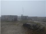
 | Gorjane (Železno) - Rigelj
Rigelj is a 626-meter-high indistinct peak in the Orlice range, on which a few antennas stand....
1 h 20 min |
 | Višnja Gora - Sveti Duh (Polževo)
The Church of the Holy Spirit is located at 630 meters above sea level on a hill above Hotel Polževo. The stamp is a few dozen meters away, along...
1 h 30 min |
 | Selo pri Vodicah - Rašica (Vrh Staneta Kosca) (by road)
Vrh Staneta Kosca, better known as Rašica, is located north of Ljubljana, more precisely above the villages of Rašica and Dobeno. From the summit...
1 h 20 min |
 | Mekinje nad Stično - Sveti Lambert
Sveti Lambert is located on an inconspicuous rise near the village of Pristava nad Stično. From the summit, once the site of a castle where Duche...
1 h 5 min |
 | Lokev - Kokoš
The Koča na Kokoši mountain hut is located on Jirmanec peak, just 5 minutes from the forested Kokoš. From the summit, situated south of Lokavsko ...
1 h 30 min |
 | Krvavi Potok - Kokoš
The Koča na Kokoši mountain hut is located on Jirmanec peak, just 5 minutes from the forested Kokoš. From the summit, situated south of Lokavsko ...
1 h 30 min |
| Prelože pri Lokvi - Kokoš
The Koča na Kokoši mountain hut is located on Jirmanec peak, just 5 minutes from the forested Kokoš. From the summit, situated south of Lokavsko ...
1 h 30 min |
 | Mekinje nad Stično - Pristava above Stična
Pristava nad Stično is a small village on a scenic rise north of Stična. Slightly above the village near the Partizanski dom lies a broad, panora...
1 h 5 min |
 | Hrpelje - Hrpeljska gora
Hrpeljska gora, also known as Mišja šoga, is a 737-meter-high peak located south of Hrpelje. From its partly vegetated summit, there are beautifu...
1 h 30 min |