 | Kozji hrbet - Možic
Možic is a 1,602 m high peak located west of Soriška Planina. At the very summit there is an old military bunker bearing the name of the peak and...
1 h |
 | Volovljek - Kranjska reber (on unmarked path)
Kranjska reber, also known as Vrh Kašne planine (1435 m), is a mountain of volcanic origin. From the summit, which has a registration box with a ...
1 h 15 min |
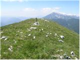 | Bohinjsko sedlo - Slatnik (northwestern peak) (direct way)
Slatnik is a panoramic mountain located west of the Soriška Planina ski resort. From its grassy summit there is a beautiful view of the Škofjeloš...
1 h |
| Bohinjsko sedlo - Slatnik (northwestern peak) (by Lajnar)
Slatnik is a panoramic mountain located west of the Soriška Planina ski resort. From its grassy summit there is a beautiful view of the Škofjeloš...
1 h 15 min |
 | Križovec - Ptičji vrh
Ptičji vrh is a 1550-meter-high mountain located in the main ridge of the Karavanke, between Struška and Golica. From the summit, through which t...
1 h |
 | Kajfežev rob - Kamniški vrh
Kamniški vrh is a 1259-metre-high mountain located north of Kamnik, more precisely between Stahovica and the Korošica valley. From the summit, wh...
1 h 15 min |
 | Dom na Lazni - Stanov rob
Stanov rob is a 1191-meter-high peak on the ridge of the precipitous Govce. From the summit, there are nice views over much of Govce, parts of th...
1 h 10 min |
 | Za Malim vrhom - Krevl
Krevl is a 1515-meter-high peak situated south of the Kobla ski area, more precisely between the Kobla peak and Kravja Črna gora. From the summit...
1 h |
 | Završnica (Pri žagi) - Smokuški vrh
Smokuški vrh is a panoramic mountain located on the ridge between the Završnica Valley and the Gorenjska plain. From the summit, where there is a...
1 h |
 | Cenc - Špičasti vrh (on road over Novina)
Špičasti vrh is a forest-covered mountain located south of the village of Zadlog. To ensure the summit is not without a view, a 13-meter-high woo...
1 h 30 min |
 | Dom Pristava in Javorniški Rovt - Španov vrh
Španov vrh is a 1334-meter-high mountain in the Karavanke that rises between Javorniški Rovt and Planina pod Golico. From the scenic summit, acce...
1 h 30 min |
| Planina pod Golico - Španov vrh
Španov vrh is a 1334-meter-high mountain in the Karavanke that rises between Javorniški Rovt and Planina pod Golico. From the scenic summit, acce...
1 h 15 min |
 | Planina Lom - Kobilja glava
Kobilja glava is a 1,475-meter-high peak located east of Tolmin. From the summit, where a cross stands, there is a beautiful view of Krn, the ran...
1 h 15 min |
 | Pri Žagi (Javorniški Rovt) - Alničje
Alničje is a 1145 m high ridge-like rise that ascends from the southwest above the Jesenice settlements of Koroška Bela and Javornik, extending n...
1 h |
 | Koča na Gozdu - Visoki Mavrinc
Visoki Mavrinc (Špica v Sedelcih) is a 1562 m high mountain between Suha, Mala, and Velika Pišnica. From the summit, where a wooden cross and ple...
1 h 15 min |
 | Makekova Kočna - Skubrov vrh
Skubrov vrh is a 1276 m high mountain rising steeply above the Ravenska Kočna valley. The forested summit offers no views....
1 h 10 min |
 | Makekova Kočna - Turni
Turni is a lesser-known peak above the eponymous cliffs that rise above Planšarsko jezero. From the summit, which features a logbook box, a beaut...
1 h |
 | Matevljek - Petelinjek
Petelinjek is a 1212 m high peak located in the Racna gora range. From the summit, where there is a small metal chair, a cairn, and an old ladder...
1 h 15 min |
 | Pri Žagi (Javorniški Rovt) - Velika Boncla
Velika Boncla is a 1,241-meter-high, partly rocky peak located between Javorniški Rovt and the Stamare mountain pasture in the Karawanks. From th...
1 h |
 | Rotek - Erbelc
Erbelc is a 1,308-meter-high peak that rises steeply above Zgornja Sorica. From the summit, which has a summit logbook, there is a fine view of t...
1 h 15 min |
| Spodnje Danje - Erbelc
Erbelc is a 1,308-meter-high peak that rises steeply above Zgornja Sorica. From the summit, which has a summit logbook, there is a fine view of t...
1 h 15 min |
 | Rotek - Tonderškofel
Tonderškofel is a 1,326-meter-high peak located between Soriška peč and Erbelc. From the partly overgrown summit, which has no marked trail leadi...
1 h 15 min |
 | Planina pod Golico - Na pečeh at Črni Vrh
Na pečeh is a lesser-known panoramic peak at 1,318 meters above sea level, rising east above the village of Planina pod Golico. Before the Španov...
1 h 5 min |
 | Polja - Kališje
Kališje is a lesser-known peak in the western part of the Karawanks. From the summit, where transmitters are located, there are some views toward...
1 h 40 min |
 | Bela Peč - Ojstri vrh (above Prevala) (past peak Seduc)
Ojstri vrh is a 1,197-meter-high mountain located between the Seduc peak and Prevala. From the summit, there is a beautiful view of the surroundi...
1 h 30 min |
 | Planina Smrečica (Poglajnov rovt) - Turn (above Bohinjska Bela)
Turn is a panoramic and precipitous peak located above Bohinjska Bela. From the summit, there is a nice view of Ratitovec, Jelovica, the Kamnik-S...
1 h 40 min |
| Zatrnik - Turn (above Bohinjska Bela)
Turn is a panoramic and precipitous peak located above Bohinjska Bela. From the summit, there is a nice view of Ratitovec, Jelovica, the Kamnik-S...
1 h 40 min |
 | Topla (Končnik) - Šoparjev vrh
Šoparjev vrh is a 1,524-meter-high mountain located between Olševa and Peca, more precisely on the ridge separating the Koprivna Valley from the ...
1 h 15 min |
| Koprivna (Kumer) - Šoparjev vrh
Šoparjev vrh is a 1,524-meter-high mountain located between Olševa and Peca, more precisely on the ridge separating the Koprivna Valley from the ...
1 h 10 min |
| Pod Peco / Koprein-Petzen - Šoparjev vrh
Šoparjev vrh is a 1,524-meter-high mountain located between Olševa and Peca, more precisely on the ridge separating the Koprivna Valley from the ...
1 h 35 min |
 | Sveta Jedert (Lajše) - Bela peč (Podbliška gora) (via Rigli)
Bela peč is situated on the edge of Jelovica above the village Podblica. From the top of the cliff a beautiful view opens up towards the mentione...
1 h 30 min |
| Sveta Jedert (Lajše) - Bela peč (Podbliška gora) (upper part on the road)
Bela peč is situated on the edge of Jelovica above the village Podblica. From the top of the cliff a beautiful view opens up towards the mentione...
1 h 30 min |
 | Koča na Pikovem - Jesenik (Jesenikov vrh)
Jesenik, also known as Jesenikov vrh, is a 1,199-meter-high forested peak situated between Mežica and Podpeca....
1 h 5 min |
 | Koča na Pikovem - Veliki vrh (above Mežiška dolina) (via Pikov vrh)
Veliki vrh is a 1,165-meter-high peak located between Mežica and Črna na Koroškem. On the summit, beside the television transmitters, there is a ...
1 h 10 min |
 | Koča na Pikovem - Šumahov vrh (via Pikov and Veliki vrh)
Šumahov vrh is a 1,155-meter-high peak on which a wooden cross stands. From the summit, which descends steeply towards Žerjav, a nice view opens ...
1 h 35 min |
 | Završnica (Pri žagi) - Tolsti vrh (at Poljška planina) (via saddle Kališča)
Tolsti vrh is a 1,225-meter-high peak located between Završnica Valley and Draga Valley. The summit lies in forest, but a viewpoint just below of...
1 h 25 min |
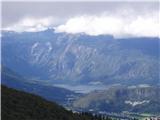
 | Bohinjsko sedlo - Črni vrh (above Soriška planina)
Črni vrh is a fairly panoramic peak located above Bohinj Pass. From the partly vegetated summit and its surroundings, fine views open towards Boh...
1 h |
 | Završnica (Pri žagi) - Pleče
Pleče is a 1,131-meter-high peak located north of Sveti Peter above Begunje. The summit is overgrown with forest, but near the top some views ope...
1 h 5 min |
 | Zatrnik - Berjanca
Berjanca is a 1,264 m high peak above the namesake mountain pasture. An abandoned ski lift from the former Zatrnik ski area used to reach the sum...
1 h 35 min |
 | Medvodje - Medvodnica (via Tržiška Bistrica)
Medvodnica is a 1,202-meter-high mountain situated between the Košutnik and Tržiška Bistrica streams. The summit lies within the forest, offering...
1 h 30 min |
| Medvodje - Medvodnica (via Košutnik)
Medvodnica is a 1,202-meter-high mountain situated between the Košutnik and Tržiška Bistrica streams. The summit lies within the forest, offering...
1 h 25 min |
 | Erjavčev rovt - Bela peč (above Dovje)
Bela peč is a lesser-known peak located above the marked trail from Dovje to Dovška Baba. From the summit, there is a beautiful view to the south...
1 h 15 min |
 | Dovje - Blažčeva skala (western path)
Blažčeva skala is a 1,091-meter-high hill located northeast of Mojstrana and Dovje. The summit, known more among climbers than hikers due to the ...
1 h |
 | Breitalm - Zachenkreuz
Zachenkreuz is a 1,601-meter-high peak situated above the Teichalm mountain pasture. On the summit, mostly overgrown by sparse forest, stands a w...
1 h 15 min |
 | 2nd turn of Vršič road - Škrbinjek
Škrbinjek is a 1,341-meter-high peak in the Julian Alps and Triglav National Park. The summit is located 2 km south-southwest of Kranjska Gora or...
1 h |
 | Pension Camping Holzmeister - Zechnerschlag (Rohregg)
Zechnerschlag, or Rohregg, is a 1434-meter-high mountain situated in the Almenland nature park. From the summit, where a cross stands, a beautifu...
1 h 30 min |
 | Straßegg - Zechnerschlag (Rohregg)
Zechnerschlag, or Rohregg, is a 1434-meter-high mountain situated in the Almenland nature park. From the summit, where a cross stands, a beautifu...
1 h 30 min |
 | Dražgoše (Jelenšče) - Britmanca (gentle path)
Britmanca is a 1,231-meter-high peak on the edge of the Jelovica plateau. Slightly south and lower from the summit along a well-worn path lies a ...
1 h 15 min |