 | Bohinjsko sedlo - Možic (by Lajnar)
Možic is a 1,602 m high peak located west of Soriška Planina. At the very summit there is an old military bunker bearing the name of the peak and...
1 h 30 min |
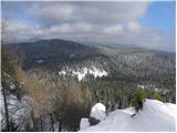
 | end of road on Vogar - Pršivec (direct way)
Pršivec is a panoramic mountain above Lake Bohinj. The view is extensive in all directions: Triglav and the surrounding mountains are clearly vis...
1 h 30 min |
 | Furlanovo zavetišče pri Abramu - Vojkova koča na Nanosu
Vojkova koča is located on the southern edge of the high karst Nanos plateau, near Pleša. This is the prominent peak with television transmitters...
2 h |
 | Kramarica - Smrekovec (by road)
Smrekovec is a mountain of volcanic origin on the eastern edge of the Smrekovec mountain range. The wide grassy summit features a pyramid with a ...
1 h 30 min |
 | Dom na Smrekovcu - Komen (Direct way)
At 1684 meters, Komen is the highest peak in the Smrekovec mountain range, which borders between Styria and Carinthia. In good weather, the summi...
2 h |
 | Planina Vodol - Veliki Travnik (Turnovka)
Veliki Travnik, also known as Turnovka by the locals, is located on the western edge of the Smrekovec mountain range. From the summit, which has ...
2 h |
 | Polomova rajda - Kucelj (on Čaven) (by road)
Kucelj is located on the southern slopes of the Trnovski Forest, northwest of the Vipava Valley. From the bare summit, where a cross stands, ther...
1 h 45 min |
 | Krnica - Kucelj (on Čaven) (via Veliki Rob)
Kucelj is located on the southern slopes of the Trnovski Forest, northwest of the Vipava Valley. From the bare summit, where a cross stands, ther...
1 h 40 min |
 | Polomova rajda - Veliki Modrasovec (via Koča na Čavnu)
Veliki Modrasovec is located on the southern part of the Trnovski Forest near Predmeja. On the summit stands an old military building, which we m...
1 h 25 min |
 | Bevški vrh - Veliki Modrasovec
Veliki Modrasovec is located on the southern part of the Trnovski Forest near Predmeja. On the summit stands an old military building, which we m...
1 h 40 min |
 | Ribniška koča - Lovrenška jezera
The Lovrenška jezera are located on a high bog in the middle of Pohorje between Rogla and Ribniško Pohorje. The smaller lakes, which receive wate...
2 h 5 min |
 | Lokve - Poldanovec
Poldanovec is located in Govci, on the northern edge of the Trnovo plateau. Govci rise steeply above the valley of Gorenja Trebuša. Poldanovec is...
1 h 30 min |
 | Turški klanec - Mrzovec
Mržovec is the most prominent peak in the heart of the Trnovo Plateau. Its location offers wonderful views, though high trees obscure them from t...
1 h 30 min |
 | Usek - Huhnerkogel/Košenjak (mimo sv. Urbana)
Košenjak is located north of Dravograd and the Drava River on the border with neighbouring Austria. Access to Košenjak is possible on foot or by ...
2 h |
 | Planinski dom Vrhe - Črni vrh (Čemšeniška planina)
Črni vrh is the highest peak of Čemšeniška planina and, at 1,204 m, the second-highest peak in Posavsko hribovje. The summit has a logbook box bu...
1 h 30 min |
 | Repna dolina - Javornik (above Črni Vrh)
Javornik is a forested peak located southeast of Črni Vrh. In 1972, a wooden observation tower was built on it, rising above the treetops and off...
1 h 45 min |
 | Vodice (Mali Školj) - Javornik (above Črni Vrh)
Javornik is a forested peak located southeast of Črni Vrh. In 1972, a wooden observation tower was built on it, rising above the treetops and off...
1 h 35 min |
 | Kalce - Veliki Javornik (Javorniki)
Veliki Javornik is a 1,268-meter-high peak of the forested hills named Javorniki. The extensive Javorniki forests stretch from Postojna to Cerkni...
1 h 30 min |
 | Koča na Šumiku - Žigartov vrh
Žigartov vrh, at 1,346 meters, is the highest peak in the eastern part of Pohorje. An "observation" tower once stood on the summit, erected solel...
1 h 55 min |
 | Pohorje cable car - Žigartov vrh (via Razglednik)
Žigartov vrh, at 1,346 meters, is the highest peak in the eastern part of Pohorje. An "observation" tower once stood on the summit, erected solel...
2 h 15 min |
| Pohorje cable car - Žigartov vrh (via Mariborska koča)
Žigartov vrh, at 1,346 meters, is the highest peak in the eastern part of Pohorje. An "observation" tower once stood on the summit, erected solel...
2 h 20 min |
| Mariborska koča - Žigartov vrh
Žigartov vrh, at 1,346 meters, is the highest peak in the eastern part of Pohorje. An "observation" tower once stood on the summit, erected solel...
1 h 40 min |
 | Platak - Snježnik (via grlo)
Snježnik is a panoramic mountain in the western part of Gorski Kotar. From the summit there is a beautiful view of the Kvarner islands, Rijeka ba...
1 h 30 min |
| Platak - Snježnik (via crest)
Snježnik is a panoramic mountain in the western part of Gorski Kotar. From the summit there is a beautiful view of the Kvarner islands, Rijeka ba...
1 h 30 min |
 | Atelsko sedlo - Boskovec
Boskovec is with 1587 m the highest peak of the Golte plateau. From the top on which a lookout tower stands, a view opens up on part of Kamnik Sa...
1 h 30 min |
 | Koča na Šumiku - Klopni vrh (eastern path)
From the northwest, Klopni vrh closes off the lower-lying extensive plateau on eastern Pohorje. The horizontal cross-sectional area at 1300 m is ...
2 h |
 | Koča na Šumiku - Klopni vrh (northern path)
From the northwest, Klopni vrh closes off the lower-lying extensive plateau on eastern Pohorje. The horizontal cross-sectional area at 1300 m is ...
2 h |
 | Zgornji Goreljek - Javorov vrh (Pokljuka)
Javorov vrh is a 1,482 m high mountain amidst the vast forests of Pokljuka, specifically between the Konjska dolina and Jelje mountain pastures. ...
1 h 30 min |
 | Soriška peč - Žbajnek
Žbajnek is a 1,538 m high peak located west of Ratitovec. From its grassy summit, surrounded by sparse forest, beautiful views open up of the Jul...
1 h 30 min |
 | Bohinjsko sedlo - Kačji rob (Ovharn)
Kačji rob (Ovharn) is a 1,552 m high peak situated between the Zgornji Jirn mountain pasture and the lesser-known Žbanjek peak. From the summit, ...
2 h |
| Soriška peč - Kačji rob (Ovharn)
Kačji rob (Ovharn) is a 1,552 m high peak situated between the Zgornji Jirn mountain pasture and the lesser-known Žbanjek peak. From the summit, ...
2 h 30 min |
 | Dom na Paškem Kozjaku - Štrukljev vrh
Štrukljev vrh is, alongside Špik (1,108 m) and Basališče (1,272 m), one of the three main peaks of Paški Kozjak, a roughly 10 km long, narrow and...
1 h 30 min |
 | St. John the Baptist on Ojstrica - Kozji vrh (at Košenjak)
Kozji vrh is a 1,383-meter-high peak located above Pernice; it is also the highest peak in the Municipality of Muta....
1 h 35 min |
 | Koča na Klopnem vrhu - Pesek
Pesek is a 1,423-meter-high peak on Pohorje, located above Koča na Pesku....
2 h 23 min |
 | Koča na Šumiku - Veliki vrh (on Pohorje)
Veliki vrh is a 1344-meter-high peak located above the RTC Jakec - Trije kralji ski slope. The highest point of the peak is in the forest, but ju...
2 h |
 | Teichalm (Teichalmsee) - Rote Wand (lower path)
Rote Wand is a 1,505-meter-high mountain in the Graz Mountains in Styria, Austria. The name "Rote Wand" (red wall) comes from its southeast-facin...
2 h 15 min |
| Teichalm (Teichalmsee) - Rote Wand (upper path)
Rote Wand is a 1,505-meter-high mountain in the Graz Mountains in Styria, Austria. The name "Rote Wand" (red wall) comes from its southeast-facin...
2 h 15 min |
 | Feistritzsattel - Grabmayr-Kogel
Grabmayr-Kogel is a lesser-known peak located southeast of the Pfaffensattel pass. From the partly vegetated summit, views open up toward the sum...
1 h 40 min |
 | St. Vinzenz (St. Vinzenz) - Dreieckkogel
Dreieckkogel is a 1,528-meter-high peak in the Golica/Koralpe range, north of Sobota Lake/Stausee Soboth. At the summit there is a cairn with a s...
1 h 35 min |
 | Knödelhütte - Hirschegger Alm (southern peak)
The southern peak in the Hirschegger Alm ridge is located west of the settlement of Hirschegg. From the summit, where a cross stands, a beautiful...
1 h 35 min |
| Unterauerlinger Hütte - Hirschegger Alm (southern peak)
The southern peak in the Hirschegger Alm ridge is located west of the settlement of Hirschegg. From the summit, where a cross stands, a beautiful...
1 h 25 min |
 | Planinski dom Orlove stine - Svilaja (past Umac)
Svilaja is a 1509-meter grassy peak above Peručko Lake, north of the town of Sinj. The summit features a cross and a concrete pillar. From the to...
2 h |
 | Sommeralm - Osser
Osser is a 1548-meter-high peak situated above the Teichalm plateau. From the summit, where a cross stands, a beautiful view opens up over the su...
2 h |
| Teichalm (Harrerhütte) - Osser
Osser is a 1548-meter-high peak situated above the Teichalm plateau. From the summit, where a cross stands, a beautiful view opens up over the su...
1 h 35 min |
 | Straßegg - Hochschlag
Hochschlag is a 1580-meter-high panoramic peak located in the Fischbacher Alpen mountain group. From the summit, where a cross and a summit regis...
1 h 45 min |
 | Hebalm (Gasthaus Zur Rehbockhütte) - Barofen
Barofen is a panoramic peak between the Weinebene Pass and the mountain road to Hebalm. On its 1,720 m high summit stands a cross with a summit r...
2 h |
 | Weinebene Straße - Barofen
Barofen is a panoramic peak between the Weinebene Pass and the mountain road to Hebalm. On its 1,720 m high summit stands a cross with a summit r...
1 h 40 min |
| Gasthof Pfeifferstocker - Barofen
Barofen is a panoramic peak between the Weinebene Pass and the mountain road to Hebalm. On its 1,720 m high summit stands a cross with a summit r...
2 h |
 | Weinebene Straße - Renneiskogel
Renneiskogel is a lesser-known pathless peak in the Lavanttal Alps, north of the Weinebene Pass....
1 h 25 min |
| Gasthof Pfeifferstocker - Renneiskogel
Renneiskogel is a lesser-known pathless peak in the Lavanttal Alps, north of the Weinebene Pass....
1 h 45 min |
 | Teichalm (Teichalmsee) - Gschaidberg (upper path)
Gschaidberg (also Gschaid-Nock or simply Gschaid) is a 1,239 m high mountain in the Graz Mountains in Austria's Styria.It is part of the Almenlan...
1 h 55 min |
| Teichalm (Teichalmsee) - Gschaidberg (past Gerlerkreuz)
Gschaidberg (also Gschaid-Nock or simply Gschaid) is a 1,239 m high mountain in the Graz Mountains in Austria's Styria.It is part of the Almenlan...
1 h 55 min |
| Teichalm (Angerwirt) - Gschaidberg
Gschaidberg (also Gschaid-Nock or simply Gschaid) is a 1,239 m high mountain in the Graz Mountains in Austria's Styria.It is part of the Almenlan...
1 h 50 min |
 | Schanzsattel - Stanglalpe
Stanglalpe is a peak in the Fischabacher Alpen mountain group, which lies in the hills east of the Mur. The peak itself is situated beside a road...
2 h 20 min |
 | Crossroads below Zvonik - Bitoraj
Bitoraj (also Veliki Bitoraj or Burni Bitoraj) is a 1,386-meter-high peak located south of the settlement Vrata. The peak is an HPO point. From t...
1 h 30 min |
 | Raxalm-Berggasthof (Rax) - Preiner Wand (Rax)
Preiner Wand is a panoramic peak in the Rax mountain group, where a large cross stands....
1 h 40 min |
 | Kugina kuća - Laktin vrh
Laktin vrh is a panoramic grassy peak in Central Velebit, east of the main ridge. It is a checkpoint for HPO and the Velebit Circuit. From the su...
1 h 30 min |