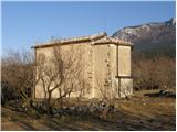
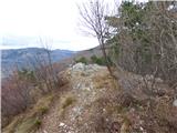
 | Hunting cottage Muljava - Mali Velebit (Petrova gora)
Mali Velebit is a 420-meter-high peak on Petrova gora....
30 min |
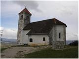
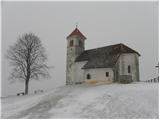
 | Tolmin - Kozlov rob (learning trail)
Kozlov rob, or Grad as the locals call it, is a 426-meter-high hill located above Tolmin. From the summit, which features renovated ruins of the ...
30 min |
 | Gorica pri Slivnici - Gradišče (above Slivniško jezero) (western path)
Gradišče above Slivniško Lake lies between the settlements of Gorica pri Slivnici and Tratna pri Grobelnem. From the logbook box on Gradišče, a f...
30 min |
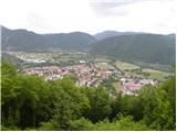
 | Laško (cemetery Laško) - Church of St. Michael at Šmihel
The Church of St. Michael at Šmihel is situated on a scenic hill above Laško. From the church, beautiful views open up to Veliko Kozje, Kopitnik,...
40 min |
| Laško (cemetery Laško) - Church of St. Michael at Šmihel (past Sveti Krištof)
The Church of St. Michael at Šmihel is situated on a scenic hill above Laško. From the church, beautiful views open up to Veliko Kozje, Kopitnik,...
52 min |
 | Ljubljana (Zalog) - Castle Stari grad (Stari Osterberg)
Stari grad, or Stari Osterberg, was first mentioned in the 12th century (less likely as early as 1015), at which time the castle belonged to the ...
30 min |
 | Podgrad - Castle Stari grad (Stari Osterberg) (on Ostrovrhar trail)
Stari grad, or Stari Osterberg, was first mentioned in the 12th century (less likely as early as 1015), at which time the castle belonged to the ...
45 min |
 | Kubed - Lačna
Lačna is a 451-meter-high hill located between Gračišče, Kubed, and Hrastovlje. The summit, which features a metal observation tower offering nic...
45 min |
 | Straža - Želin - Sveti Pavel (Straža)
The Church of St. Paul is situated above the settlement of Straža, specifically between the Cerknica and Zaganjalščica streams. From the church, ...
35 min |
 | Stoperce - Sveta Ana above Stoperce
The Church of St. Anne is situated on a 460-meter-high hill rising west of the settlement Stoperce. From the church or its nearby surroundings, a...
40 min |
 | Pichla bei Radkersburg - Königsberg
Königsberg is a 462-meter-high peak situated in Steiermark near the border with Slovenia. On the summit of volcanic origin, there are some memori...
40 min |
 | Jezero - Sveta Ana
The Church of St. Ana is situated on a small panoramic hill above Jezero, Podpeč, and Preserje. From the top, which has a panorama board, a nice ...
35 min |
 | Podpeč - Sveta Ana
The Church of St. Ana is situated on a small panoramic hill above Jezero, Podpeč, and Preserje. From the top, which has a panorama board, a nice ...
30 min |
 | Bevško - Špicberg
Špicberg, or Ostri Vrh, is a ridge directly above Trbovlje. The ridge consists of several indistinct peaks; the highest is 490 m high, with a car...
35 min |
 | Brezje pri Dobrovi - Vrhovčev grič (via Strmca)
Vrhovčev grič is an indistinct, forested peak located just a few meters off the marked trail between Debeli hrib and Strmca....
50 min |
 | Radeče - Svinjski rt
Svinjski rt is a panoramic peak located north of Radeče. From the top a beautiful view opens towards the Sava River and Posavje. The logbox is lo...
45 min |
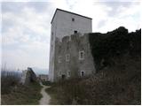
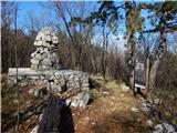
 | Škofja Loka - Divja Loka Castle (Stari grad)
Divja Loka Castle (also known as Stari grad) above Škofja Loka is located on a small hill north of Nemški grič. First mentioned in 1202, it was r...
40 min |
 | Loka pri Žusmu (Žamerk) - Castle Žusem
Castle Žusem (German Sussenheim), of which only ruins remain today, is located east to northeast of Žusem, a peak with a lookout tower....
50 min |
 | Lovska koča Muljava - Veliki Petrovac (Petrova gora) (Roman path)
Veliki Petrovac is a 512-meter-high peak on Petrova gora....
50 min |
 | Slovenske Konjice - Konjice Castle
Konjice Castle (Konjiški Stari grad), built in the 12th century, is one of the oldest castles in Slovenia. From the castle, which is slowly being...
30 min |
 | Stari trg (Pilštanj) - Vina gora
Vina Gora is a scenic hill rising east of the medieval market town of Pilštanj. Its summit has been converted into an attractive open-air museum ...
45 min |
| Lesično - Vina gora
Vina Gora is a scenic hill rising east of the medieval market town of Pilštanj. Its summit has been converted into an attractive open-air museum ...
45 min |
| Lesično - Vina gora (along the water educational trail)
Vina Gora is a scenic hill rising east of the medieval market town of Pilštanj. Its summit has been converted into an attractive open-air museum ...
45 min |
 | Vrtovin - Školj Svetega Pavla above Vrtovin
Školj sv. Pavla is located on a panoramic hill above the village of Vrtovin, which lies west of Ajdovščina. From the church, near which the logbo...
35 min |
 | Pirman - Turjak Castle (longer path)
Turjak Castle (Slovenian: Grad Turjak or Turjaški grad; German: Burg Ursperg, later Schloss Auersperg) lies on the edge of Turjak village and is ...
40 min |
 | Prevala - Veliki hrib (survey point 526)
Veliki hrib, or kota 526 (the latter mainly associated with World War I; also Mali vrh on some maps), is a peak located northwest of Škabrijel, w...
35 min |
 | Dravograd lake - Church of the Holy Cross at Dravograd
The Church of the Holy Cross near Dravograd stands on a panoramic rise from which fine views extend over the western Pohorje, Slovenjgraška Basin...
45 min |
 | Gradišče pri Vipavi - Plaz
Plaz or Vrh Plaza is a 528-meter-high peak above the Vipava Valley, more precisely between Vipava and Gradišče. From the summit, which has a summ...
40 min |
 | Tourist farm Žurej - Church of St. Helena on Javor
The Church of St. Helena stands on Javor, just off the highest point of the nearby peak where there is also a summit register box and an NOB monu...
45 min |
 | Ljubljana (Zalog) - Debenji vrh
Debenji vrh, also known as Debni or Deben vrh, at 530 m, is the highest peak of Kašeljski grič, a small range located between the Besnica valley ...
45 min |
 | Ljubljana (Zalog) - Debenji vrh
Debenji vrh, also known as Debni or Deben vrh, at 530 m, is the highest peak of Kašeljski grič, a small range located between the Besnica valley ...
45 min |
| Ljubljana (Zalog) - Debenji vrh (Trda varianta)
Debenji vrh, also known as Debni or Deben vrh, at 530 m, is the highest peak of Kašeljski grič, a small range located between the Besnica valley ...
40 min |
 | Ljubljana (G Design Hotel) - Gradišče (above Dobrova)
Gradišče is a forest-covered peak located south of the settlement Dobrova and north of Brezovica pri Ljubljani. From the summit, where there is a...
45 min |
 | Brezovica pri Ljubljani (Radna) - Gradišče (above Dobrova)
Gradišče is a forest-covered peak located south of the settlement Dobrova and north of Brezovica pri Ljubljani. From the summit, where there is a...
45 min |
 | Zbelovo (railway underpass) - Ljubična gora (via Marijine stopinje)
Ljubična gora is an elongated hill above the settlements of Ljubično, Zbelovo and Zbelovska gora. The peak is hidden in forest and not well visib...
45 min |
 | Zbelovo (railway underpass) - Ljubična gora
Ljubična gora is an elongated hill above the settlements of Ljubično, Zbelovo and Zbelovska gora. The peak is hidden in forest and not well visib...
45 min |
 | Lovnik - Ljubična gora
Ljubična gora is an elongated hill above the settlements of Ljubično, Zbelovo and Zbelovska gora. The peak is hidden in forest and not well visib...
45 min |
 | Veliki Erjavec - Vodenica
Vodenica is a vast, forest-covered hill southwest of Ozalj. The summit is an HPO point and part of the Dubovačka planinska pot. The summit is par...
45 min |
 | Treskavac - Veli Vrh
Veli Vrh is not the highest peak on the island of Krk, but it offers the best view of the entire island, the Bay of Rijeka / Riješki zaliv, Učka,...
50 min |
 | Galicija - Planinski dom Šentjungert
The mountain hut is located just a few meters below the summit of Gora, where the Church of St. Kunigunda stands; it was built in the 14th centur...
45 min |
 | Jakob pri Šentjurju - Rifnik
Rifnik is a 568-meter-high peak situated south of Šentjur pri Celju. The summit, known for its archaeological site, offers nice views towards Šen...
45 min |
| Šentjur - Rifnik
Rifnik is a 568-meter-high peak situated south of Šentjur pri Celju. The summit, known for its archaeological site, offers nice views towards Šen...
45 min |
 | Vezovje (bus station Vezovje most) - Rifnik
Rifnik is a 568-meter-high peak situated south of Šentjur pri Celju. The summit, known for its archaeological site, offers nice views towards Šen...
45 min |
 | Košnica - Hom above Celje
Hom is a forest-covered peak located north of Košnica pri Celju. The summit features a logbook box and a small bench....
40 min |
 | Trebnje Castle - Trebni vrh (steep path)
Trebni vrh is a 581-meter-high hill located south or southwest of Trebnje. On the forested summit stands a bench, and nearby is a logbook box wit...
45 min |
| Trebnje Castle - Trebni vrh (via caves)
Trebni vrh is a 581-meter-high hill located south or southwest of Trebnje. On the forested summit stands a bench, and nearby is a logbook box wit...
50 min |
 | Migojnice - Dom na Bukovici
The mountain hut Dom na Bukovici is situated just a few meters below the summit of the forested Bukovica. From the hut, near which there is a lar...
45 min |
 | Zabukovica - Dom na Bukovici
The mountain hut Dom na Bukovici is situated just a few meters below the summit of the forested Bukovica. From the hut, near which there is a lar...
45 min |
 | Kasaze - Dom na Bukovici
The mountain hut Dom na Bukovici is situated just a few meters below the summit of the forested Bukovica. From the hut, near which there is a lar...
45 min |
 | Gleichenberg Dorf - Gleichenberger Kogel
Gleichenberger Kogel is a 598-meter-high mountain of volcanic origin located above Bad Gleichenberg in Styria....
50 min |
 | Vitovlje - Vitovski hrib (west path)
Vitovski hrib is a 604-meter-high hill located north of the village Vitovlje in the Vipava Valley. From the summit, where there is a church dedic...
40 min |
 | Vitovlje - Vitovski hrib (via Vitovlje Lake)
Vitovski hrib is a 604-meter-high hill located north of the village Vitovlje in the Vipava Valley. From the summit, where there is a church dedic...
40 min |
 | Košnica - Veliki Slomnik
Veliki Slomnik is a peak located between Košnica pri Celju and Liboje. The summit has a logbook box, but due to the surrounding forest, there are...
40 min |