 | Kranj-Stražišče (Šrotenturn) - Šmarjetna gora (east path)
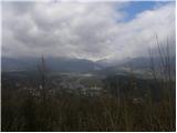
Šmarjetna gora is a panoramic peak rising above Kranj. From the summit, where the Church of St. Margaret and the Hotel Bellevue stand, a beautifu...
45 min |
| Kranj-Stražišče (Šrotenturn) - Šmarjetna gora (by cart track)
Šmarjetna gora is a panoramic peak rising above Kranj. From the summit, where the Church of St. Margaret and the Hotel Bellevue stand, a beautifu...
45 min |
 | Tičnica - Šmarjetna gora
Šmarjetna gora is a panoramic peak rising above Kranj. From the summit, where the Church of St. Margaret and the Hotel Bellevue stand, a beautifu...
50 min |
 | Strmica - Toško Čelo (via Brezarjevo brezno)
Toško Čelo is a 590-metre hill above the village of the same name. From the summit, or slightly below it, a beautiful view opens over part of Lju...
45 min |
 | Šujica (Na Gmajni) - Toško Čelo (along the stream Ostrožnik)
Toško Čelo is a 590-metre hill above the village of the same name. From the summit, or slightly below it, a beautiful view opens over part of Lju...
55 min |
 | Šujica (Na Gmajni) - Toško Čelo
Toško Čelo is a 590-metre hill above the village of the same name. From the summit, or slightly below it, a beautiful view opens over part of Lju...
50 min |
 | Mala voda - Koreno
Koreno (also known as Korena) is a 729 m high hill located north of Horjul. From the summit, which features a large cross, the church of St. Moho...
1 h 15 min |
 | Sora - Hom (steep past cemetery)
Hom is a 715 m high peak that rises steeply southwest of the village of Sora. From the summit, which is partly forested, there is a beautiful vie...
50 min |
 | Spodnje Pirniče - Grmada (Kovačeva steza)
Grmada is a 676-meter-high mountain located west of the much more visited Šmarna gora. From the summit, which has a small takeoff area, a beautif...
1 h 10 min |
 | Briše - Mali vrh
West of Polhov Gradec, between the rivers Mala voda and Velika Božna, lies the 708-meter-high hill known as Mali vrh. From the grassy summit, whi...
1 h 5 min |
 | Grgar - Vodice (by road)
Vodice (according to some records also Sveti Jakob) is a peak on the western part of the Banjška planota plateau. From the summit, which features...
1 h 15 min |
 | Podgrad - Debenji vrh
Debenji vrh, also known as Debni or Deben vrh, at 530 m, is the highest peak of Kašeljski grič, a small range located between the Besnica valley ...
1 h |
| Podgrad - Debenji vrh (via old castle Osterberg)
Debenji vrh, also known as Debni or Deben vrh, at 530 m, is the highest peak of Kašeljski grič, a small range located between the Besnica valley ...
50 min |
 | Podlipoglav - Pugled (past the guard post)
Pugled is a 615-meter-high peak situated between Podlipoglav and Veliki Lipoglav. From the summit, where a large NOB monument stands, the view is...
50 min |
 | Podlipoglav - Pugled (on the western ridge)
Pugled is a 615-meter-high peak situated between Podlipoglav and Veliki Lipoglav. From the summit, where a large NOB monument stands, the view is...
50 min |
 | Sežana - Zidovnik (Sedovnik) (by road)
Zidovnik is a 575-meter-high peak located west of Sežana. From the summit, which hosts a few transmitters, the view is limited by the forest and ...
1 h |
 | Kamnik - Visoka špica (via Krniška gora)
An indistinct but clearly visible forested hill above Kamnik from everywhere. Due to the slightly lower Čokl, on which Kamnik Castle stands, it i...
1 h |
 | Kamnik - Visoka špica (via Stari grad)
An indistinct but clearly visible forested hill above Kamnik from everywhere. Due to the slightly lower Čokl, on which Kamnik Castle stands, it i...
50 min |
 | Povodje - Veliki vrh (Rašica)
Veliki vrh is a 568-meter-high hill located west of Vrh Staneta Kosca. Just a few meters below the otherwise forested summit lies a small abyss n...
45 min |
 | Činžat - Lobnikov vrh
Lobnikov vrh is a forested peak above the Dravska dolina valley, located between the settlements of Fala and Ruta. From the east, due to its remo...
1 h |
| Fala Grad - Lobnikov vrh
Lobnikov vrh is a forested peak above the Dravska dolina valley, located between the settlements of Fala and Ruta. From the east, due to its remo...
1 h 15 min |
 | Dobrova - Vrhe above Dobrova
Vrhe is a lesser-known but significant peak at the far southeastern end of the Polhograjsko Hribovje. Several unmarked cart tracks and paths lead...
50 min |
 | Hruševo - Vrhe above Dobrova
Vrhe is a lesser-known but significant peak at the far southeastern end of the Polhograjsko Hribovje. Several unmarked cart tracks and paths lead...
1 h |
 | Izlake (Medijske toplice) - Vrhija (via Podlipovica)
Vrhija is a 648-meter-high hill located west of Izlake and east of Kolovrat. It lies between Kalanov hrib and Kolovraška reber, viewed from the N...
1 h 15 min |
 | Kamnik - Castle Stari grad Kamnik (by road)
Stari grad Kamnik, formerly known as Zgornji grad (Oberstain), is located on a scenic hill east of Kamnik called Krniška gora. Today, only ruins ...
1 h |
 | Log - Pečke (by road)
Pečke is an easily accessible peak that has seen fewer visitors lately, located north of the main Pohorje ridge. It gets more visits only on May ...
1 h 5 min |
 | Brezovica pri Ljubljani - Vrh (Debeli hrib)
Vrh is a 540-meter-high hill on the Debeli hrib ridge, which lies between the Ljubljana Marshes and the Horjulščica river valley. The view from t...
1 h |
 | Brezje pri Dobrovi - Vrh (Debeli hrib) (past Strmca)
Vrh is a 540-meter-high hill on the Debeli hrib ridge, which lies between the Ljubljana Marshes and the Horjulščica river valley. The view from t...
1 h 10 min |
 | Adergas - Apnišče (via Šterna)
Apnišče is a 740 m high mountain between Možjanca and Štefanja gora. It is the highest point of the Šenčur municipality. The forested summit offe...
1 h |
 | Preddvor - Apnišče (on footpath)
Apnišče is a 740 m high mountain between Možjanca and Štefanja gora. It is the highest point of the Šenčur municipality. The forested summit offe...
1 h 15 min |
 | Dvor - Kucelj above Polhov Gradec (on marked path)
Kucelj is a somewhat less known peak located between Polhov Gradec and Dvor pri Polhovem Gradcu. From the 705-meter-high summit, a view opens tow...
1 h |
| Dvor - Kucelj above Polhov Gradec (on unmarked path)
Kucelj is a somewhat less known peak located between Polhov Gradec and Dvor pri Polhovem Gradcu. From the 705-meter-high summit, a view opens tow...
1 h |
| Polhov Gradec - Kucelj above Polhov Gradec (via Ravnek)
Kucelj is a somewhat less known peak located between Polhov Gradec and Dvor pri Polhovem Gradcu. From the 705-meter-high summit, a view opens tow...
1 h |
 | Želimlje - Castle Stari grad above Želimlje
Stari grad above Želimlje is a forest-covered peak located between Želimlje and Rogatec above Želimlje....
50 min |
 | Železniki - Hujska (via Kres)
Hujska is a 706-meter-high peak located above Železniki, more precisely between the Dašnjica and Češnjica streams. At the summit there is a bench...
45 min |
 | Vrzdenec - Gradišče above Žažar (via Žažar)
Gradišče above Žažar is a panoramic peak topped by a large wooden cross. From the summit, which also has a summit logbook with a stamp, there is ...
1 h |
| Vrzdenec - Gradišče above Žažar (via Plesa)
Gradišče above Žažar is a panoramic peak topped by a large wooden cross. From the summit, which also has a summit logbook with a stamp, there is ...
45 min |
 | Prevalje - Brinjeva gora (above Prevalje) (via Stations of the Cross)
Brinjeva gora is a popular excursion spot for Prevalje locals, located between the Meža River and Zelenbreški Stream. On the summit stands a smal...
1 h |
| Prevalje - Brinjeva gora (above Prevalje) (south path)
Brinjeva gora is a popular excursion spot for Prevalje locals, located between the Meža River and Zelenbreški Stream. On the summit stands a smal...
1 h |
| Ravne na Koroškem - Brinjeva gora (above Prevalje)
Brinjeva gora is a popular excursion spot for Prevalje locals, located between the Meža River and Zelenbreški Stream. On the summit stands a smal...
1 h 10 min |
 | Vešter - Vrh soteske (Križna gora)
Vrh soteske is a 735 meters high peak, which is situated on the southwestern part of Križna gora. From the top, which is overgrown by the forest,...
1 h 15 min |
 | Sveta Barbara (Nova Hrastnica) - Sveti Andrej (above Zminec)
The Church of St. Andrew is located on a panoramic hill in the Sveti Andrej settlement. From the church, there is a fine view of the Škofjeloško ...
50 min |
 | Selca - Lepo brdo
Lepo brdo is a 778-metre hill rising above the Selca and Studeno settlements....
1 h |
 | Sora - Breznik (Boben)
Breznik, also known as Boben, is a 643-meter-high peak situated above the right bank of the Ločnica, more precisely above Sora, Rakovnik, Goričan...
1 h 5 min |
| Rakovnik - Breznik (Boben)
Breznik, also known as Boben, is a 643-meter-high peak situated above the right bank of the Ločnica, more precisely above Sora, Rakovnik, Goričan...
55 min |
 | Liboje - Kamčič (via organic farm Kralj - northern approach)
Kamčič is a wooded peak in the Posavje Hills, located north of Šmohor between Kotečnik to the left and Veliki Slomnik to the right. It is recogni...
45 min |
 | Podgrad - Grmadnik
Grmadnik is a 569-meter-high peak above the valley of the Besnica stream between Podgrad and Besnica. The Borovničeva pohodna pot trail runs just...
55 min |
 | Podgrad - Španov vrh (Besnica)
Španov vrh is a 559-meter-high peak above the Besnica stream valley between Podgrad and Besnica. Just below the summit runs the Borovničeva hikin...
50 min |
 | Brzika - Joški vrh
Joški vrh is a 595-meter-high peak located on the northern side of Donačka gora. A short unmarked path leads to the summit, branching off from th...
1 h 15 min |
| Prelaz Vrhe - Joški vrh
Joški vrh is a 595-meter-high peak located on the northern side of Donačka gora. A short unmarked path leads to the summit, branching off from th...
1 h 5 min |
| Sveti Jurij - Joški vrh
Joški vrh is a 595-meter-high peak located on the northern side of Donačka gora. A short unmarked path leads to the summit, branching off from th...
1 h 5 min |
 | Ruše - Lorbekov vrh
Lorbekov vrh is a 578-meter-high peak located southwest of Ruše. The summit lies in the forest, but from a meadow just below it, a nice view open...
45 min |
 | Bad Gleichenberg (Eichgraben Weg) - Bschaidkogel (via Mühlsteinbruch)
Bschaidkogel is a 563-meter-high mountain located northeast of the town of Bad Gleichenberg....
50 min |
 | Ožbalt (dam on stream Črmenica) - Turška peč (on cart track)
Turška peč is a scenic rocky outcrop above the left bank of the Drava River, along the Ožbalt to Grilov vrh path....
1 h |
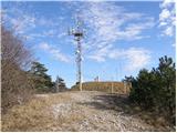
 | Ruše - Globokarjev vrh
Globokarjev vrh is situated on a small ridge between Drava and Lobnica, only a few minutes away from the Globokar farm. Several antennas stand on...
1 h 15 min |
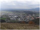
 | Slovenj Gradec - Rahtelov vrh (eastern path)
Rahtelov vrh is located north of Slovenj Gradec, above the left bank of the Mislinja River. On the summit there is a repeater facility and some t...
45 min |
| Slovenj Gradec - Rahtelov vrh (southeastern path)
Rahtelov vrh is located north of Slovenj Gradec, above the left bank of the Mislinja River. On the summit there is a repeater facility and some t...
45 min |
 | Kisovec - Castle Gamberk
Castle Gamberk (German: Gallenberg) is a castle situated on a hill above the settlement of Ržiše in the Posavsko hribovje....
1 h 10 min |
 | Zagorje ob Savi - Vinski vrh
Vinski vrh is a 616-meter-high hill, situated between the streams Medija and Kotredeščica, more precisely between the villages Vine and Zavine. T...
1 h |