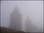
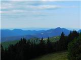
 | Kapetanova bajta - Snežnik
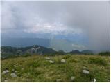
Snežnik, or Veliki Snežnik, at 1796 metres is the highest peak in the near and far surroundings, offering a beautiful view over a large part of S...
55 min |
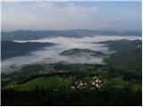
 | Lontovž - Kum (by road)
Kum, at 1,220 metres, is the highest peak in the Posavje Hills. As it rises above the Zasavje region, some call it the Zasavje Triglav. At the su...
50 min |
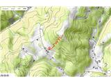
 | Bohinjsko sedlo - Možic (direct way)
Možic is a 1,602 m high peak located west of Soriška Planina. At the very summit there is an old military bunker bearing the name of the peak and...
1 h 15 min |
 | Leška gmajna - Lepenatka
Lepenatka is a grassy peak located south of the 1557-metre-high Rogatec. From the summit, which has a summit register box and stamp, there is a b...
1 h 15 min |
 | Tonkina koča na Vršiču - Vršič vrh
Vršič is a 1,737-metre-high mountain situated between the Poštarski dom hut and the Vršič pass. From the summit, where there is a registration bo...
1 h |
 | Preval - Stari vrh
Stari Vrh is a 1,217-metre-high mountain located above the ski resort of the same name. There is no view from the summit itself due to the forest...
50 min |
 | Bohinjsko sedlo - Dravh (via Lajnar)
Dravh is a 1,547-metre-high peak situated between Sorica and Soriška Planina. From the unforested summit a beautiful view opens across the Škofja...
1 h |
 | Črni Kal - Koprivnik (lower path)
Koprivnik is a 1393-meter-high mountain located between Blegoš and Mladi vrh. From the summit, which has a registration box and a stamp, the view...
1 h |
| Črni Kal - Koprivnik (via Romovec)
Koprivnik is a 1393-meter-high mountain located between Blegoš and Mladi vrh. From the summit, which has a registration box and a stamp, the view...
1 h |
 | Erjavčeva koča na Vršiču - Sovna glava (on old road)
Sovna Glava is a 1750-meter-high grassy peak situated between Prisank and the Vršič Pass. From the summit, there is a nice view of the peaks risi...
50 min |
 | Erjavčeva koča na Vršiču - Sovna glava (on footpath)
Sovna Glava is a 1750-meter-high grassy peak situated between Prisank and the Vršič Pass. From the summit, there is a nice view of the peaks risi...
45 min |
 | Zavetišče na Biba planini - Goli vrh (Šavnice) (on marked path)
Goli vrh is the highest peak of the Šavnice area, located at the far eastern end of the Menina planina plateau. From the open, unvegetated summit...
1 h 15 min |
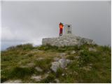
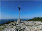
 | Atelsko sedlo - Smrekovec
Smrekovec is a mountain of volcanic origin on the eastern edge of the Smrekovec mountain range. The wide grassy summit features a pyramid with a ...
50 min |
 | Pod Hlipovcem - Komen
At 1684 meters, Komen is the highest peak in the Smrekovec mountain range, which borders between Styria and Carinthia. In good weather, the summi...
55 min |
 | Turnovka - Veliki Travnik (Turnovka)
Veliki Travnik, also known as Turnovka by the locals, is located on the western edge of the Smrekovec mountain range. From the summit, which has ...
1 h |
| Kolarica - Veliki Travnik (Turnovka)
Veliki Travnik, also known as Turnovka by the locals, is located on the western edge of the Smrekovec mountain range. From the summit, which has ...
1 h 5 min |
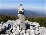
 | Preval Strgarija - Mali Golak
Mali Golak is the highest of the Golaki. It did not get its name because it is supposed to be the smallest, but because it had the smallest mount...
45 min |
 | Škrbina - Srednji Golak
Srednji Golak is located between Mali and Veliki Golak on the plateau of Trnovski gozd above Predmeja. The peak is covered with dwarf pines, and ...
1 h 15 min |
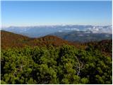
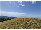
 | Snežniška Grda jama - Mali Snežnik
Mali Snežnik is a peak on the western ridge of Snežnik. Covered with dwarf pines, the summit offers beautiful views of the neighboring Veliki Sne...
1 h |
 | Gate below Mali vrh - Uršlja gora (Plešivec) (by road)
Uršlja gora, or Plešivec, is a panoramic mountain between Slovenj Gradec and Črna na Koroškem. At or just below the summit stands the Church of S...
50 min |
 | Koglereck - Huhnerkogel/Košenjak
Košenjak is located north of Dravograd and the Drava River on the border with neighbouring Austria. Access to Košenjak is possible on foot or by ...
1 h |
 | Rifugio Pelizzo - Monte Mataiur/Matajur
Matajur is a panoramic mountain located on the border between Slovenia and Italy. From the summit there is a beautiful view of Kobariški or Bregi...
45 min |
 | Rifugio Pelizzo - Monte Mataiur/Matajur (via Dom na Matajure)
Matajur is a panoramic mountain located on the border between Slovenia and Italy. From the summit there is a beautiful view of Kobariški or Bregi...
55 min |
 | Tuškov Grič - Črni vrh above Novaki
Črni vrh, the highest point of the popular Cerkno ski center, is located northeast of Novaki. Near the summit, where an artificial lake has been ...
45 min |
 | Golte (Alpine garden) - Boskovec (via Hleviška planina)
Boskovec is with 1587 m the highest peak of the Golte plateau. From the top on which a lookout tower stands, a view opens up on part of Kamnik Sa...
1 h 5 min |
| Golte (Alpine garden) - Boskovec (Severjeva pot)
Boskovec is with 1587 m the highest peak of the Golte plateau. From the top on which a lookout tower stands, a view opens up on part of Kamnik Sa...
1 h |
 | Pečana - Gladki vrh (Ratitovec)
Gladki vrh (Ratitovec), at 1,667 meters, is the most visited peak in the Ratitovec range. From its bare summit, which features a panorama board, ...
50 min |
 | Pečana - Altemaver (Ratitovec)
Altemaver (Ratitovec), at 1,678 meters, is the highest peak of Ratitovec. From its grassy summit, there is a beautiful view of the Julian Alps, J...
55 min |
 | Ski hotel Vogel - Visoki Orlov rob
Visoki Orlov rob is a 1,800-meter-high peak located right next to the upper station of the Šija single-chair lift. From the summit, which lies sl...
1 h 15 min |
 | Raspet - Kopa (Cimprovka)
Kopa is a 1360 m high peak or panoramic promontory from which a nice view opens up on Cerkno, the hills surrounding it, Ratitovec, Trnovski gozd,...
1 h 10 min |
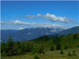
 | Bohinjsko sedlo - Slatnik (southeastern peak) (via Lajnar)
Slatnik (southeastern peak) is a panoramic mountain that rises steeply above Baška grapa on one side and descends more gently toward Soriška plan...
1 h 5 min |
| Bohinjsko sedlo - Slatnik (southeastern peak) (past barracks)
Slatnik (southeastern peak) is a panoramic mountain that rises steeply above Baška grapa on one side and descends more gently toward Soriška plan...
1 h 10 min |
 | Teichalm (Parking Heulantsch) - Heulantsch
Heulantsch is a 1,473 m high grassy hill above Teichalm, which together with "Sommeralm" forms the largest area of mountain meadows in the Alps.F...
45 min |
 | Pension Camping Holzmeister - Heulantsch
Heulantsch is a 1,473 m high grassy hill above Teichalm, which together with "Sommeralm" forms the largest area of mountain meadows in the Alps.F...
1 h 15 min |
 | Feistritzsattel - Harterkogel
Harterkogel is a 1523-meter-high peak situated in the ridge connecting the Pfaffensattel and Feistritzsattel saddles. On the panoramic top, there...
50 min |
 | Zeller Kreuz - Teufelstein
Teufelstein is a 1,498-meter-high mountain in the Fischbacher Alpen group. At the summit there is a cross with a summit logbook, and slightly bel...
55 min |
 | Pension Camping Holzmeister - Osser
Osser is a 1548-meter-high peak situated above the Teichalm plateau. From the summit, where a cross stands, a beautiful view opens up over the su...
1 h 15 min |
 | Nechnitz - Gschaidberg
Gschaidberg (also Gschaid-Nock or simply Gschaid) is a 1,239 m high mountain in the Graz Mountains in Austria's Styria.It is part of the Almenlan...
45 min |
 | Raxalm-Berggasthof (Rax) - Jakobskogel (Rax)
Jakobskogel is a 1,737-meter-high peak in the Rax mountain group, located above the Ottohaus hut. From the summit, where a cross stands, beautifu...
50 min |
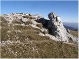
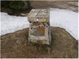
 | Kugina kuća - Lisac
Lisac is a lesser-known peak in Central Velebit, south of Šatorina. The grassy summit with some rocks has a logbook and stamp from the Lički gors...
1 h |