 | Stara Fužina - Triglavski dom na Kredarici
The Triglav Hut at Kredarica is the highest-lying serviced Slovenian mountain hut. It is open all year round but outside the season only on an em...
6 h 50 min |
 | Dom v Dragi - Begunjščica (via Roblekov dom)
Begunjščica is a mountain range in the Karawanks east of Stol. Its highest peak is Veliki Vrh, which at over 2,000 m offers a fine view across ce...
4 h 20 min |
 | Poljana (Završnica) - Hochstuhl/Stol (Žirovniška pot)
Stol is, at 2,236 m, the highest peak in the Karawanks. From the summit, which has a registration box and stamp, a beautiful view opens onto the ...
4 h 20 min |
 | Poljana (Završnica) - Hochstuhl/Stol (Zabreška pot)
Stol is, at 2,236 m, the highest peak in the Karawanks. From the summit, which has a registration box and stamp, a beautiful view opens onto the ...
4 h 40 min |
 | Podljubelj - Veliki vrh (Košuta) (via Matizovec)
Veliki Vrh, at 2,088 m, is the westernmost two-thousander in Slovenia's longest ridge, the Košuta. From the summit, which has a registration box ...
4 h 15 min |
 | Krnica - Debela peč
Debela peč is a 2014 m high mountain that rises steeply above the Krma valley on one side and gently descends towards the expansive Pokljuka fore...
5 h 30 min |
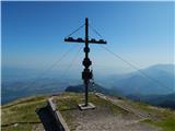
 | Laško - Storžič (via Javornik)
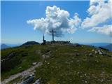
Storžič is a 2132 m high mountain located in the western part of the Kamnik-Savinja Alps. From the summit, where there is a cross, a beautiful vi...
4 h 45 min |
 | Zalog - Storžič (below Psica and through southwest groove)
Storžič is a 2132 m high mountain located in the western part of the Kamnik-Savinja Alps. From the summit, where there is a cross, a beautiful vi...
4 h 40 min |
| Zalog - Storžič (via Planina Javornik and through southwest groove)
Storžič is a 2132 m high mountain located in the western part of the Kamnik-Savinja Alps. From the summit, where there is a cross, a beautiful vi...
4 h 35 min |
 | Luče - Velika Raduha (mimo Koče na Loki pod Raduho)
Velika Raduha, at 2062 m, is the highest peak of the Raduha range, which rises steeply east of Robanov Kot. From the summit, with its registratio...
4 h 40 min |
| Bistra - Velika Raduha
Velika Raduha, at 2062 m, is the highest peak of the Raduha range, which rises steeply east of Robanov Kot. From the summit, with its registratio...
4 h 55 min |
 | Dom v Lepeni - Krn
Krn, at 2244 m, is the highest peak of the Krn mountain group, which rises steeply above the central part of the Soča River. From the summit, fea...
5 h |
 | Drežnica - Krn (south way)
Krn, at 2244 m, is the highest peak of the Krn mountain group, which rises steeply above the central part of the Soča River. From the summit, fea...
4 h 45 min |
 | Trenta - Zasavska koča na Prehodavcih
The Zasavska koča na Prehodavcih mountain hut is located on a panoramic rise above the Valley of the Triglav Lakes. From the hut, open in the sum...
4 h 15 min |
 | Poljana (Završnica) - Prešernova koča na Stolu (Zabreška pot)
The Prešernova koča na Stolu mountain hut is located just a few metres below the summit of the 2198 m high Mali Stol. From the hut or the nearby ...
4 h 25 min |
 | Koča pri Savici - Lanževica (via Bogatinsko sedlo)
Lanževica is a 2003 m high peak located between Bogatinsko sedlo and Oslova škrbina. From the summit, where remnants of the former Rapallo border...
5 h |
| Koča pri Savici - Lanževica (via Lepa Komna)
Lanževica is a 2003 m high peak located between Bogatinsko sedlo and Oslova škrbina. From the summit, where remnants of the former Rapallo border...
5 h |
 | Pod Zjabci - Lanževica (via Lepa Komna)
Lanževica is a 2003 m high peak located between Bogatinsko sedlo and Oslova škrbina. From the summit, where remnants of the former Rapallo border...
5 h |
| Dom v Lepeni - Lanževica (via Bogatinsko sedlo)
Lanževica is a 2003 m high peak located between Bogatinsko sedlo and Oslova škrbina. From the summit, where remnants of the former Rapallo border...
5 h |
 | Koča pri Savici - Mahavšček (via planina Govnjač)
Mahavšček, or Veliki Bogatin, is a 2008 m high mountain on the northwestern edge of the Lower Bohinj Mountains. From the summit, with its somewha...
4 h 55 min |
 | Mojstrana - Sleme
The mountain is located between Mojstrana and Kukova špica. The summit is grassy and offers a very beautiful view towards Kukova špica. There is ...
4 h 15 min |
 | Planina Polog - Batognica (via planina Sleme)
Batognica is a 2164 m high mountain that was the site of the so-called mine warfare during World War I. Remnants of the fighting between Italian ...
5 h 45 min |
| Planina Polog - Batognica (via Prehodci)
Batognica is a 2164 m high mountain that was the site of the so-called mine warfare during World War I. Remnants of the fighting between Italian ...
6 h |
| Koča pri Savici - Batognica (via Prehodci)
Batognica is a 2164 m high mountain that was the site of the so-called mine warfare during World War I. Remnants of the fighting between Italian ...
7 h 10 min |
| Drežnica - Batognica (south way)
Batognica is a 2164 m high mountain that was the site of the so-called mine warfare during World War I. Remnants of the fighting between Italian ...
4 h 50 min |
| Koča pri Savici - Batognica (via Krn lake and Prag)
Batognica is a 2164 m high mountain that was the site of the so-called mine warfare during World War I. Remnants of the fighting between Italian ...
7 h 30 min |
 | Poljana (Završnica) - Potoški Stol (Žirovniška pot)
Potoški Stol is located between Stol and Vajnež on the border with Austria. A cross stands just a few metres below the grassy summit. The finest ...
4 h 25 min |
 | Zauchen - Hochobir (Ojstrc) (via Kunetov graben)
Ojstrc (Hochobir) is the highest peak of the smaller Obir range. It is located west of Železna Kapla (Eisenkappel) on the Austrian side of the Ka...
5 h 5 min |
 | Podkanja vas / Wildenstein - Hochobir (Ojstrc)
Ojstrc (Hochobir) is the highest peak of the smaller Obir range. It is located west of Železna Kapla (Eisenkappel) on the Austrian side of the Ka...
5 h |
 | Podkraj / Unterort - Petzen (Kordeschkopf) (Peca (Kordeževa glava))
Kordeževa glava, better known as Peca, is the highest peak of the Peca range. It is located on the border with Austria above the Mežiška dolina v...
5 h 5 min |
 | Globasnitz - Petzen (Kordeschkopf) (Peca (Kordeževa glava))
Kordeževa glava, better known as Peca, is the highest peak of the Peca range. It is located on the border with Austria above the Mežiška dolina v...
6 h 30 min |
 | Mežica - Petzen (Kordeschkopf) (Peca (Kordeževa glava)) (easy path)
Kordeževa glava, better known as Peca, is the highest peak of the Peca range. It is located on the border with Austria above the Mežiška dolina v...
5 h |
| Podpeca (Helenski potok) - Petzen (Kordeschkopf) (Peca (Kordeževa glava)) (via Mirjanca and on easy path)
Kordeževa glava, better known as Peca, is the highest peak of the Peca range. It is located on the border with Austria above the Mežiška dolina v...
4 h 40 min |
 | Podkraj / Unterort - Wackendorfer Spitze
Veška kopa, also known as Veški vrh or by its German name Wackendorfer Spitze, is the northernmost two-thousander in the Peca range. From its ind...
5 h |
 | Globasnitz - Wackendorfer Spitze
Veška kopa, also known as Veški vrh or by its German name Wackendorfer Spitze, is the northernmost two-thousander in the Peca range. From its ind...
4 h 35 min |
 | Podkraj / Unterort - Wackendorfer Spitze (on path P7)
Veška kopa, also known as Veški vrh or by its German name Wackendorfer Spitze, is the northernmost two-thousander in the Peca range. From its ind...
5 h 5 min |
 | Podkraj / Unterort - Feistritzer Spitze
Bistriška špica is a 2113 m high peak located on the Austrian side of Peca. From the summit, which features a cross, there is a fine view of the ...
4 h 45 min |
 | Globasnitz - Feistritzer Spitze
Bistriška špica is a 2113 m high peak located on the Austrian side of Peca. From the summit, which features a cross, there is a fine view of the ...
5 h |
 | Podkraj / Unterort - Feistritzer Spitze (on path P7)
Bistriška špica is a 2113 m high peak located on the Austrian side of Peca. From the summit, which features a cross, there is a fine view of the ...
5 h 30 min |
 | Podkraj / Unterort - Končnikov vrh (Peca)
Končnikov vrh (German: Knieps) is a 2109 m high peak situated in the central part of Peca. From the grassy summit, there is a beautiful view of t...
4 h 20 min |
| Globasnitz - Končnikov vrh (Peca)
Končnikov vrh (German: Knieps) is a 2109 m high peak situated in the central part of Peca. From the grassy summit, there is a beautiful view of t...
5 h 45 min |