 | Zadnjica - Kanjavec (via Dolič)
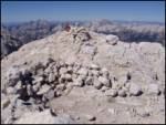
Kanjavec is a 2,569-meter-high mountain located between Dolič and Hribarice. From the summit, which has a logbook box and a stamp, a beautiful vi...
6 h 35 min |
 | Koča pri Savici - Kanjavec (via Triglavska jezera)
Kanjavec is a 2,569-meter-high mountain located between Dolič and Hribarice. From the summit, which has a logbook box and a stamp, a beautiful vi...
6 h 30 min |
 | Na Razpotju - Planjava
Planjava is a smaller mountain group east of Kamniško sedlo. It has two peaks eastern and western. The marked path leads to the eastern peak, wh...
5 h |
 | Mače - Storžič
Storžič is a 2132 m high mountain located in the western part of the Kamnik-Savinja Alps. From the summit, where there is a cross, a beautiful vi...
4 h |
| Laško - Storžič (via Sveti Lovrenc and over Bašeljski preval)
Storžič is a 2132 m high mountain located in the western part of the Kamnik-Savinja Alps. From the summit, where there is a cross, a beautiful vi...
4 h 25 min |
| Bašelj - Storžič (via Sveti Lovrenc and over Bašeljski preval)
Storžič is a 2132 m high mountain located in the western part of the Kamnik-Savinja Alps. From the summit, where there is a cross, a beautiful vi...
5 h 5 min |
| Bašelj - Storžič
Storžič is a 2132 m high mountain located in the western part of the Kamnik-Savinja Alps. From the summit, where there is a cross, a beautiful vi...
4 h |
| Bašelj - Storžič (via hospital Košuta)
Storžič is a 2132 m high mountain located in the western part of the Kamnik-Savinja Alps. From the summit, where there is a cross, a beautiful vi...
4 h 10 min |
| Spodnja Kokra - Storžič
Storžič is a 2132 m high mountain located in the western part of the Kamnik-Savinja Alps. From the summit, where there is a cross, a beautiful vi...
5 h 35 min |
| MHE Zabukovec - Storžič (via Bašeljski preval)
Storžič is a 2132 m high mountain located in the western part of the Kamnik-Savinja Alps. From the summit, where there is a cross, a beautiful vi...
4 h |
 | Dom v Kamniški Bistrici - Brana
Brana is a mountain above Kamniško sedlo. From the spacious summit, which has a registration box and a small cross, there is a very beautiful vie...
5 h |
 | Belca - Mittagskogel/Kepa
Kepa (also Jepa, German: Mittagskogel) is a panoramic mountain in the western Karavanke, located on the border ridge between Slovenia and Austria...
4 h 15 min |
 | Podrožca / Rosenbach - Mittagskogel/Kepa
Kepa (also Jepa, German: Mittagskogel) is a panoramic mountain in the western Karavanke, located on the border ridge between Slovenia and Austria...
5 h 10 min |
| Čemernica / Tschemernitzen - Mittagskogel/Kepa
Kepa (also Jepa, German: Mittagskogel) is a panoramic mountain in the western Karavanke, located on the border ridge between Slovenia and Austria...
5 h 5 min |
 | Na Razpotju - Ojstrica (via Škarje)
Ojstrica, named for its sharp shape, rises steeply above Korošica, the Logarska Dolina valley, and Robanov Kot. From the summit, which has a regi...
4 h 15 min |
 | Pred Belo - Ojstrica
Ojstrica, named for its sharp shape, rises steeply above Korošica, the Logarska Dolina valley, and Robanov Kot. From the summit, which has a regi...
6 h 45 min |
 | Robanov kot - Ojstrica (via Mala Ojstrica)
Ojstrica, named for its sharp shape, rises steeply above Korošica, the Logarska Dolina valley, and Robanov Kot. From the summit, which has a regi...
5 h 15 min |
 | Pred Belo - Ojstrica
Ojstrica, named for its sharp shape, rises steeply above Korošica, the Logarska Dolina valley, and Robanov Kot. From the summit, which has a regi...
6 h 45 min |
| Robanov kot - Ojstrica (via Kocbekov dom)
Ojstrica, named for its sharp shape, rises steeply above Korošica, the Logarska Dolina valley, and Robanov Kot. From the summit, which has a regi...
5 h 45 min |
 | Koča pri Savici - Mala Tičarica
Mala Tičarica is a highly panoramic mountain above the Twin Triglav Lakes. From the summit there is a beautiful view toward the Koča pri Triglavs...
4 h 10 min |
 | Koča pri Savici - Tolminski Kuk (via Vrh Planje)
Tolminski Kuk is the highest peak in the Bohinj-Tolmin mountains. The summit, equipped with a registration box, offers a very beautiful view. Fro...
6 h |
 | Koča pri Savici - Zasavska koča na Prehodavcih
The Zasavska koča na Prehodavcih mountain hut is located on a panoramic rise above the Valley of the Triglav Lakes. From the hut, open in the sum...
5 h 10 min |
 | Zadnjica - Križ (via Dovška vrata)
Križ is a 2,140 m high mountain located northeast of the Kriški Podi plateau. The summit, which has a registration box with a stamp, offers a bea...
5 h 45 min |
 | Zavrzelno - Rombon
Rombon is a scenic mountain above Bovec. It is particularly known for having the most artificial tunnels in Slovenia. During the First World War,...
4 h 45 min |
| Kluže Fortress - Rombon
Rombon is a scenic mountain above Bovec. It is particularly known for having the most artificial tunnels in Slovenia. During the First World War,...
5 h |
 | Možnica - Jerebica
Jerebica is a mountain located on the border between Slovenia and Italy, between the Možnica and Jezerska valleys. From the summit, where there i...
5 h |
 | Zadnjica - Planja
The Planja summit is located between two alpine valleys: Mlinarica on the north side and Zadnjica on the south. From the summit, there is a beaut...
5 h 45 min |
 | Koča pri Savici - Veliko Špičje
Veliko Špičje is the highest peak in the ridge from Travnik to Zasavska koča. From the top, there is a very nice view of the Komna plateaus, the ...
5 h 40 min |
| Zadnjica - Veliko Špičje
Veliko Špičje is the highest peak in the ridge from Travnik to Zasavska koča. From the top, there is a very nice view of the Komna plateaus, the ...
6 h 20 min |
| Trenta - Veliko Špičje
Veliko Špičje is the highest peak in the ridge from Travnik to Zasavska koča. From the top, there is a very nice view of the Komna plateaus, the ...
6 h 30 min |
 | Koča pri Savici - Mala Zelnarica (via Štapce)
Mala Zelnarica is a 2310-meter-high peak situated between the Valley of the Triglav Lakes and the Za Kopico Valley. From the summit, which has a ...
5 h 55 min |
 | Koča pri Savici - Mala Zelnarica (via Vrata)
Mala Zelnarica is a 2310-meter-high peak situated between the Valley of the Triglav Lakes and the Za Kopico Valley. From the summit, which has a ...
6 h 40 min |
 | Zadnjica - Bovški Gamsovec (via Luknja)
Bovški Gamsovec is a 2392 m high mountain in the immediate vicinity of Triglav. From the summit there is a magnificent view of Triglav and its no...
5 h 15 min |
| Zadnjica - Bovški Gamsovec (via Dovška vrata)
Bovški Gamsovec is a 2392 m high mountain in the immediate vicinity of Triglav. From the summit there is a magnificent view of Triglav and its no...
5 h 30 min |
 | Valbruna - Jof di Miezegnot/Poldašnja špica (via Planina Strehica)
Poldašnja špica is the easternmost two-thousander in the Malborghetto mountains group (Monti di Malborgheto). From the mountain, which has many r...
4 h |
 | Malborghetto - Jof di Miezegnot/Poldašnja špica
Poldašnja špica is the easternmost two-thousander in the Malborghetto mountains group (Monti di Malborgheto). From the mountain, which has many r...
4 h |
 | Bagni di Lusnizza - Cima Alta (Due Pizzi)
Dve špici (Due Pizzi) comprise two peaks in the Naborjet mountains group, namely Cima Alta (2046 m) and Cima Vildiver (2008 m). Both peaks have a...
4 h |
 | Ovčja vas / Valbruna - Kamniti lovec / Cima del Cacciatore
Kamniti lovec is a popular excursion point above Trbiž. Due to the short approach, shortened by the cable car to Višarje, it is well visited. Two...
4 h |
 | Soča - Bavški Grintavec
Bavški Grintavec is a mighty mountain that rises steeply above the valleys of Bavšica, Zadnja Trenta, and Soča. All approaches to the summit are ...
5 h 15 min |
 | Reklanska dolina - Sart / Žrd
Žrd, or Monte Sart in Italian, is a panoramic mountain located on the northwestern ridge of the Kanin mountains. The summit, which has a logbook ...
5 h 15 min |
 | Solbica / Stolvizza - Sart / Žrd (via Ricovero Igor Crasso)
Žrd, or Monte Sart in Italian, is a panoramic mountain located on the northwestern ridge of the Kanin mountains. The summit, which has a logbook ...
6 h |
 | Zadnjica - Pihavec
Pihavec is a spacious and panoramic peak located south of Kriški Podi. From the summit, which has a logbook and stamp, there are nice views of mo...
5 h 15 min |
 | Unterpirkach - Hochstadel (Dreitörlweg)
Hochstadel is a 2,681-meter peak in the eastern part of the picturesque Lienz Dolomites. From the summit, where a large cross commemorates those ...
6 h 50 min |
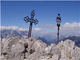
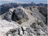
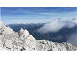
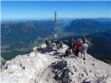 | Parking Alpspitzbahn - Alpspitze (Ostgrat)
Alpspitze is a 2628-meter-high peak in the Wetterstein mountain group. From the summit, where a cross from 1946 stands, there is a very nice view...
6 h 15 min |
 | Parking Alpspitzbahn - Bernadeinkopf (via Osterfelderkopf)
Bernadeinkopf is a 2143-meter-high peak in the Wetterstein mountain group. From the summit, where a cross stands, there is a very nice view of th...
5 h 30 min |
 | Val Aupa - Sernio (via normale)
Sernio (Ital. Monte Sernio / Furlan: Serenât or Crete di Seregnò) is a 2,187 m high mountain in the Carnic Alps in Italy, between the Aupa river ...
4 h 30 min |