 | Pri Mlinču - Mangart (italijanska pot)
Mangart (also spelled Mangrt; both forms are grammatically correct) is a mountain that attracts a large number of visitors in summer. Access to t...
4 h 45 min |
 | Aljažev dom v Vratih - Dolkova špica (western way)
Dolkova špica is a 2,591 m high mountain situated between Stenar and Škrlatica. From the summit, which has a registration box, a beautiful panora...
5 h 15 min |
 | The Kot Valley - Triglavski dom na Kredarici
The Triglav Hut at Kredarica is the highest-lying serviced Slovenian mountain hut. It is open all year round but outside the season only on an em...
5 h 10 min |
| Rudno polje - Triglavski dom na Kredarici
The Triglav Hut at Kredarica is the highest-lying serviced Slovenian mountain hut. It is open all year round but outside the season only on an em...
5 h 25 min |
| Uskovnica (Lom) - Triglavski dom na Kredarici (via Planina Spodnji Tosc)
The Triglav Hut at Kredarica is the highest-lying serviced Slovenian mountain hut. It is open all year round but outside the season only on an em...
5 h 35 min |
| Uskovnica (Razpotje) - Triglavski dom na Kredarici (via planina Spodnji Tosc)
The Triglav Hut at Kredarica is the highest-lying serviced Slovenian mountain hut. It is open all year round but outside the season only on an em...
5 h 30 min |
 | Gozdec - Prestreljenik (via dom Petra Skalarja)
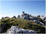
Prestreljenik is a 2,499 m high mountain located in the heart of the Kanin range. From the summit, where there is a registration box shaped like ...
5 h 45 min |
| B station - Prestreljenik (via Krnica)
Prestreljenik is a 2,499 m high mountain located in the heart of the Kanin range. From the summit, where there is a registration box shaped like ...
4 h 25 min |
| Sella Nevea - Prestreljenik (via Rifugio Gilberti)
Prestreljenik is a 2,499 m high mountain located in the heart of the Kanin range. From the summit, where there is a registration box shaped like ...
4 h 15 min |
 | Ruski križ - Špik (via Kačji graben)
Špik is a 2,472 m high mountain situated in the heart of the Martuljek group. From the summit, clearly visible from the road through Gozd Martulj...
4 h 45 min |
 | The Kot Valley - Begunjski vrh
Begunjski Vrh is a 2,461 m high mountain located in the heart of the highest peaks of the Julian Alps. From the summit, which has a registration ...
4 h 40 min |
 | Bodenbauer - Hochstuhl/Stol
Stol is, at 2,236 m, the highest peak in the Karawanks. From the summit, which has a registration box and stamp, a beautiful view opens onto the ...
4 h 30 min |
| Ogris - Hochstuhl/Stol
Stol is, at 2,236 m, the highest peak in the Karawanks. From the summit, which has a registration box and stamp, a beautiful view opens onto the ...
4 h 30 min |
 | Bodenbauer - Vertatscha/Vrtača
Vrtača is a 2181 m high peak located east of Stol. From the summit, where a large peg stands, a beautiful view opens over parts of the Julian Alp...
4 h 45 min |
| Ogris - Vertatscha/Vrtača
Vrtača is a 2181 m high peak located east of Stol. From the summit, where a large peg stands, a beautiful view opens over parts of the Julian Alp...
4 h 45 min |
 | Koča pod slapom Rinka - Planjava
Planjava is a smaller mountain group east of Kamniško sedlo. It has two peaks eastern and western. The marked path leads to the eastern peak, wh...
4 h 45 min |
| Planina Podvežak - Planjava (via Srebrno sedlo)
Planjava is a smaller mountain group east of Kamniško sedlo. It has two peaks eastern and western. The marked path leads to the eastern peak, wh...
4 h 15 min |
 | Planina Podvežak - Planjava (via Škarje)
Planjava is a smaller mountain group east of Kamniško sedlo. It has two peaks eastern and western. The marked path leads to the eastern peak, wh...
4 h 45 min |
| Planina Ravne - Planjava (via Dolga trata and Srebrno sedlo)
Planjava is a smaller mountain group east of Kamniško sedlo. It has two peaks eastern and western. The marked path leads to the eastern peak, wh...
5 h 30 min |
| Planina Ravne - Planjava (via Dolga trata and Škarje)
Planjava is a smaller mountain group east of Kamniško sedlo. It has two peaks eastern and western. The marked path leads to the eastern peak, wh...
6 h |
 | Kraljev dol - Planjava (via Srebrno sedlo)
Planjava is a smaller mountain group east of Kamniško sedlo. It has two peaks eastern and western. The marked path leads to the eastern peak, wh...
4 h 30 min |
 | Ravne - Mittagskogel/Kepa
Kepa (also Jepa, German: Mittagskogel) is a panoramic mountain in the western Karavanke, located on the border ridge between Slovenia and Austria...
4 h 15 min |
 | Dom na Gospincu - Kalška gora (via Zvoh)
Kalška gora lies between the Kalški greben and Kokrsko sedlo. From the grassy summit there is a beautiful view towards the nearby Kalški greben. ...
4 h 45 min |
| Planina Jezerca - Kalška gora (via Dom na Krvavcu and Zvoh)
Kalška gora lies between the Kalški greben and Kokrsko sedlo. From the grassy summit there is a beautiful view towards the nearby Kalški greben. ...
5 h |
 | Planina Ravne - Ojstrica (via Mala Ojstrica)
Ojstrica, named for its sharp shape, rises steeply above Korošica, the Logarska Dolina valley, and Robanov Kot. From the summit, which has a regi...
4 h 15 min |
 | Planina Ravne - Ojstrica (via Dolga trata and Kocbekov dom)
Ojstrica, named for its sharp shape, rises steeply above Korošica, the Logarska Dolina valley, and Robanov Kot. From the summit, which has a regi...
5 h 15 min |
| Planina Ravne - Ojstrica (via Dolga trata and Mala Ojstrica)
Ojstrica, named for its sharp shape, rises steeply above Korošica, the Logarska Dolina valley, and Robanov Kot. From the summit, which has a regi...
4 h 45 min |
| Kraljev dol - Ojstrica (via Kocbekov dom)
Ojstrica, named for its sharp shape, rises steeply above Korošica, the Logarska Dolina valley, and Robanov Kot. From the summit, which has a regi...
4 h 15 min |
 | Planina Zapleč - Krn
Krn, at 2244 m, is the highest peak of the Krn mountain group, which rises steeply above the central part of the Soča River. From the summit, fea...
4 h 30 min |
 | Tolminske Ravne - Tolminski Kuk (via planina Razor)
Tolminski Kuk is the highest peak in the Bohinj-Tolmin mountains. The summit, equipped with a registration box, offers a very beautiful view. Fro...
4 h 45 min |
 | The Kot Valley - Cmir
Cmir is located between two alpine valleys: Vrata and the lesser-known valley Za Cmirom. From the summit, there is a beautiful view of the peaks ...
6 h 10 min |
 | Aljažev dom v Vratih - Križ (via Sovatna)
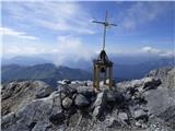
Križ is a 2,140 m high mountain located northeast of the Kriški Podi plateau. The summit, which has a registration box with a stamp, offers a bea...
5 h |
 | Podnar / Bodenbauer - Prešernova koča na Stolu
The Prešernova koča na Stolu mountain hut is located just a few metres below the summit of the 2198 m high Mali Stol. From the hut or the nearby ...
4 h 25 min |
| Vgriz / Ogris - Prešernova koča na Stolu
The Prešernova koča na Stolu mountain hut is located just a few metres below the summit of the 2198 m high Mali Stol. From the hut or the nearby ...
4 h 25 min |
 | Kriška planina - Kalški greben (via Zvoh)
Kalški greben is a 2224 m high peak and the highest point of the ridge bearing the same name. From the summit, where there is a summit register a...
4 h 10 min |
| Dom na Gospincu - Kalški greben (via Zvoh)
Kalški greben is a 2224 m high peak and the highest point of the ridge bearing the same name. From the summit, where there is a summit register a...
4 h 10 min |
| Planina Jezerca - Kalški greben (via Dom na Krvavcu and Zvoh)
Kalški greben is a 2224 m high peak and the highest point of the ridge bearing the same name. From the summit, where there is a summit register a...
4 h 25 min |
 | Tolminske Ravne - Batognica
Batognica is a 2164 m high mountain that was the site of the so-called mine warfare during World War I. Remnants of the fighting between Italian ...
6 h 45 min |
 | Sella Nevea - Rombon (via 636)
Rombon is a scenic mountain above Bovec. It is particularly known for having the most artificial tunnels in Slovenia. During the First World War,...
6 h 45 min |
| Sella Nevea - Rombon (along the ski piste)
Rombon is a scenic mountain above Bovec. It is particularly known for having the most artificial tunnels in Slovenia. During the First World War,...
6 h 30 min |
 | Aljažev dom v Vratih - Planja (via Sovatna)
The Planja summit is located between two alpine valleys: Mlinarica on the north side and Zadnjica on the south. From the summit, there is a beaut...
6 h 5 min |
| Vršič - Planja
The Planja summit is located between two alpine valleys: Mlinarica on the north side and Zadnjica on the south. From the summit, there is a beaut...
5 h 5 min |
 | Planina Blato - Veliko Špičje (via Štapce)
Veliko Špičje is the highest peak in the ridge from Travnik to Zasavska koča. From the top, there is a very nice view of the Komna plateaus, the ...
5 h 45 min |
| Planina Blato - Veliko Špičje (Za Kopico)
Veliko Špičje is the highest peak in the ridge from Travnik to Zasavska koča. From the top, there is a very nice view of the Komna plateaus, the ...
7 h 20 min |
 | Aljažev dom v Vratih - Bovški Gamsovec (via Luknja)
Bovški Gamsovec is a 2392 m high mountain in the immediate vicinity of Triglav. From the summit there is a magnificent view of Triglav and its no...
4 h 35 min |
| Aljažev dom v Vratih - Bovški Gamsovec (via Sovatna)
Bovški Gamsovec is a 2392 m high mountain in the immediate vicinity of Triglav. From the summit there is a magnificent view of Triglav and its no...
4 h 45 min |
 | Plockenpass - Monte Coglians (Hohe Warte) (via Rifugio Marinelli)
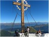
Monte Coglians (Hohe Warte) is, at 2,780 meters, the highest mountain of the Carnic Alps. From the summit, which has a cross and a bell, there is...
5 h |
| Rifugio Tolazzi - Monte Coglians (Hohe Warte) (via Rifugio Marinelli)
Monte Coglians (Hohe Warte) is, at 2,780 meters, the highest mountain of the Carnic Alps. From the summit, which has a cross and a bell, there is...
4 h 25 min |
 | Sella Nevea - Velika Črnelska špica (on ski track)
Velika Črnelska špica is located in the Kanin mountains on the border between Italy and Slovenia. From the top there is a very nice view of the V...
4 h 30 min |
| Sella Nevea - Velika Črnelska špica (via 636)
Velika Črnelska špica is located in the Kanin mountains on the border between Italy and Slovenia. From the top there is a very nice view of the V...
4 h 45 min |
 | Reißkofelbad - Reißkofel (via east ridge)
Reißkofel is a 2371 m high mountain in the Gailtal Alps. The summit, marked by a cross, also features a summit register. The view is particularly...
4 h 45 min |
 | Cave del Mole - Viš/Jof Fuart
Viš is a 2,666 m high peak in the western Julian Alps. From the summit, which features a statue of St. Mary and a cross beside it, there are fine...
4 h 30 min |
 | Aljažev dom v Vratih - Pihavec (via Sovatna)
Pihavec is a spacious and panoramic peak located south of Kriški Podi. From the summit, which has a logbook and stamp, there are nice views of mo...
5 h 15 min |
 | Sella Nevea - Koštrunove špice (via Forcella Lavinal dell Orso)
Koštrunove špice is a 2,502-meter-high peak located southwest of Viš (2,666 m). From the summit, a beautiful view opens up over much of the weste...
4 h 30 min |
 | Tolminske Ravne - Zeleni vrh (via planina Razor)
Zeleni vrh is a 2052-meter-high mountain located east of the highest peak of the Spodnje Bohinjske gore. From the grassy summit, which drops prec...
4 h 20 min |
 | Erschbaum - Große Kinigat / Monte Cavallino (western way)
Große Kinigat / Monte Cavallino is a 2,689-meter peak in the Carnic Alps. Located in the western part, it is one of the few there made of limesto...
6 h |
 | Coot Parking Lot - Velika Baba (Kanin) (via Skutnik)
Velika Baba is the southernmost two-thousander of the Kanin mountains. It is separated from the main ridge to the north by the saddle Med Baban, ...
4 h 20 min |
 | Plockenpass - Cima di Mezzo / Keller Warte (via Rifugio Marinelli)
Cima di Mezzo (German: Keller Warte) is a 2,713-meter-high mountain in the Carnic Alps on the border between Austria and Italy. A small cross and...
4 h 35 min |
 | The Kot Valley - Kredarica
Kredarica is a 2,541-meter-high panoramic peak located between Triglav and Rž. From the summit, a nice view opens up towards Triglav and the surr...
5 h 5 min |
 | Rudno polje - Kredarica
Kredarica is a 2,541-meter-high panoramic peak located between Triglav and Rž. From the summit, a nice view opens up towards Triglav and the surr...
5 h 30 min |
 | Weißenbach - Spitzegel / Negal (via Bodenalm)
Spitzegel / Negal is a 2,119 m high mountain in the Gailtal Alps in Austria. The ridge with its highest peak Spitzegel / Nagal logically connects...
4 h 30 min |
 | Ruski križ - Lipnica (via Koča v Krnici)
Lipnica is a high-mountain peak standing in the immediate vicinity of Špik and representing its southern neighbour. It lies on the ridge that des...
4 h 15 min |