 | Gozd - Tolsti vrh (Sheep Trail across Kriška Gora)
Tolsti vrh, located west of Storžič, is at 1715 metres also the highest peak of the Kriška gora range, which rises steeply above central Gorenjsk...
2 h 30 min |
 | Tominčev slap Waterfall - Dobrča
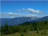
Dobrča is a 1634-metre mountain located between Begunje and Tržič. From the summit, which has a registration box with a stamp, the view opens onl...
3 h |
 | Draga - Dobrča (via Ledena trata)
Dobrča is a 1634-metre mountain located between Begunje and Tržič. From the summit, which has a registration box with a stamp, the view opens onl...
3 h |
 | Hudi Graben - Dobrča (via Lešanska planina)
Dobrča is a 1634-metre mountain located between Begunje and Tržič. From the summit, which has a registration box with a stamp, the view opens onl...
2 h 35 min |
| Hudi Graben - Dobrča
Dobrča is a 1634-metre mountain located between Begunje and Tržič. From the summit, which has a registration box with a stamp, the view opens onl...
2 h 30 min |
 | Grahovše - Veliki Javornik (Ženiklovec)
Veliki Javornik (also known as Ženiklovec) is a 1716 m high peak located between Storžič and Stegovnik. From the grassy summit with its registrat...
2 h 45 min |
 | Tržiški graben - Veliki Javornik (Ženiklovec)
Veliki Javornik (also known as Ženiklovec) is a 1716 m high peak located between Storžič and Stegovnik. From the grassy summit with its registrat...
2 h 30 min |
| Grahovše - Veliki Javornik (Ženiklovec) (via Rekar)
Veliki Javornik (also known as Ženiklovec) is a 1716 m high peak located between Storžič and Stegovnik. From the grassy summit with its registrat...
2 h 45 min |
 | Smrečje - Pečovnik (survey point 1668) (by road)
Pečovnik (1668 m) is a 1668-meter-high mountain located between Plešivec (1801 m) and Virnikov Grintovec (1654 m). From its grassy summit on the ...
2 h 45 min |
 | Polja - Ofen/Peč (via Petelinjek)
Peč (also known as Tromeja; in Italian Monte Forno, in German Dreiländereck or Ofen) is a 1508 m high peak located at the tripoint between Sloven...
2 h 45 min |
 | Planina pod Golico - Klek (via Ovčarska koča)
Klek is a 1753-metre-high mountain located between Hruški vrh and the better-known Golica. The summit, on the border between Slovenia and Austria...
3 h |
 | Log - Vošca
Vošca is a 1737 m high peak located west of Trupejevo poldne. From the grassy summit, there is a beautiful view of the Julian Alps, western Karaw...
2 h 30 min |
 | Srednji Vrh - Vošca (via Zajčnik)
Vošca is a 1737 m high peak located west of Trupejevo poldne. From the grassy summit, there is a beautiful view of the Julian Alps, western Karaw...
2 h 35 min |
 | Srnjak - Vošca
Vošca is a 1737 m high peak located west of Trupejevo poldne. From the grassy summit, there is a beautiful view of the Julian Alps, western Karaw...
2 h 45 min |
 | Bela Peč - Vivodnik (past peak Seduc)
Vivodnik, at 1508 meters, is the highest peak of Menina planina, a plateau rising south of Gornji Grad. From the summit, which has a small observ...
4 h 20 min |
| Bela Peč - Vivodnik (via Ovčje jame)
Vivodnik, at 1508 meters, is the highest peak of Menina planina, a plateau rising south of Gornji Grad. From the summit, which has a small observ...
4 h 25 min |
 | Source of Ljubija - Smrekovec (by road)
Smrekovec is a mountain of volcanic origin on the eastern edge of the Smrekovec mountain range. The wide grassy summit features a pyramid with a ...
2 h 30 min |
 | Valley of stream Žep - Komen
At 1684 meters, Komen is the highest peak in the Smrekovec mountain range, which borders between Styria and Carinthia. In good weather, the summi...
2 h 30 min |
 | Javorje (Mala Črna) - Komen (via Hlipovec)
At 1684 meters, Komen is the highest peak in the Smrekovec mountain range, which borders between Styria and Carinthia. In good weather, the summi...
4 h 20 min |
 | Javorje (Mala Črna) - Veliki Travnik (Turnovka) (steep path)
Veliki Travnik, also known as Turnovka by the locals, is located on the western edge of the Smrekovec mountain range. From the summit, which has ...
4 h 25 min |
 | Mislinjski graben (Pestotnik) - Rogla (via Ostruščica)
Rogla is a peak in the middle of the eponymous ski resort. The peak is forested with a small clearing on which stands a lookout tower. The tower ...
3 h |
 | Smrečje - Pečovnik (by road)
Pečovnik is a 1640-meter-high peak situated in the ridge of mountains between Košuta and Virnikov Grintovec. From the partly vegetated peak, a ni...
2 h 35 min |
 | Ivarčko jezero - Uršlja gora (Plešivec) (Grofovska pot)
Uršlja gora, or Plešivec, is a panoramic mountain between Slovenj Gradec and Črna na Koroškem. At or just below the summit stands the Church of S...
2 h 50 min |
 | Trbiž / Tarviso - Svete Višarje / Monte Lussari (on transport road)
Svete Višarje / Monte Lussari is a pilgrimage site for Slavs, Germans, and Romance peoples. Already in the 16th century, the mountain was called ...
3 h 25 min |
 | Jevšček - Monte Mataiur/Matajur
Matajur is a panoramic mountain located on the border between Slovenia and Italy. From the summit there is a beautiful view of Kobariški or Bregi...
2 h 30 min |
 | Poljšica pri Gorjah (Zatrata) - Galetovec (on footpath)
Galetovec is an indistinct peak on the southeastern part of the Pokljuka plateau. From the summit, which has a logbook, there is a nice view of t...
2 h 35 min |
 | Draga - Šentanski vrh (via Ledena trata)
Šentanski vrh, located in the Dobrča range just five minutes from the main peak, offers a nice view of the central Karawanks, the Storžič group, ...
3 h 5 min |
 | Hudi Graben - Šentanski vrh (via Lešanska planina)
Šentanski vrh, located in the Dobrča range just five minutes from the main peak, offers a nice view of the central Karawanks, the Storžič group, ...
2 h 40 min |
| Hudi Graben - Šentanski vrh
Šentanski vrh, located in the Dobrča range just five minutes from the main peak, offers a nice view of the central Karawanks, the Storžič group, ...
2 h 35 min |
 | NC Planica - Glave (by ski jumping hill)
Glave is an indistinct side ridge of Ponca, rising steeply west of Planica. Maps incorrectly label its highest peak (1,760 m) as Ovčja stran; tha...
2 h 30 min |
| Rateče (Ledine) - Glave
Glave is an indistinct side ridge of Ponca, rising steeply west of Planica. Maps incorrectly label its highest peak (1,760 m) as Ovčja stran; tha...
2 h 50 min |
 | Grant - Jehlc (Špičasta kupa)
Different maps list various names for Jehlc, which also vary in elevation. Locals call the peak Jehlc (1625 m), while newer maps show Jehelc and ...
2 h 45 min |
| Stržišče - Jehlc (Špičasta kupa)
Different maps list various names for Jehlc, which also vary in elevation. Locals call the peak Jehlc (1625 m), while newer maps show Jehelc and ...
3 h 30 min |
 | Spodnje Danje - Altemaver (Ratitovec)
Altemaver (Ratitovec), at 1,678 meters, is the highest peak of Ratitovec. From its grassy summit, there is a beautiful view of the Julian Alps, J...
2 h 30 min |
 | Spodnje Danje - Kremant (Ratitovec)
Kremant is a 1,654 m high peak located on the western part of Ratitovec. From the summit, where a stamp is attached to a metal pole, a nice view ...
2 h 30 min |
 | Srnjak - Tamarča
Tamarča is a lesser-known peak located northwest of Vošca. From its summit, surrounded by larch forest, a nice view opens up onto the Martuljek m...
2 h 30 min |
 | Radovna - Vošni vrh
Vošni vrh is a 1,621-meter-high mountain located in the ridge that begins at Radovna and ends at Tosc. Although the summit itself is in the fores...
3 h |
 | Kneške Ravne - Grušnica (via Planina na Kalu)
Grušnica is a 1,570-meter-high peak located between Čadrg, the Tolminka valley, and Tolminske Ravne. From the summit, which drops steeply toward ...
4 h 30 min |
 | Javorje - Gradovec (path over Glin)
Gradovec is a 1,692-meter-high peak located north of the ridge of Spodnje Bohinjske gore, specifically above the mountain pasture Poljana. From t...
3 h 10 min |
 | Jasna - Visoka peč (via Mojčin dom)
Visoka peč is a 1,749-meter-high mountain located southwest of Ciprnik. From its summit, which steeply descends towards Planica and features a sm...
3 h 30 min |
| Kranjska Gora - Visoka peč (via Bedančev dom)
Visoka peč is a 1,749-meter-high mountain located southwest of Ciprnik. From its summit, which steeply descends towards Planica and features a sm...
3 h 25 min |
 | Mislinjski graben (Pestotnik) - Ostruščica
Ostruščica is a 1,498-meter-high peak located west of the ski slopes on Rogla....
2 h 30 min |
 | Trbiž / Tarviso - Florjanka / Monte Florianca (on transport road)
Florjanka is a 1,653-meter-high mountain on the Italian side of the Julian Alps. At or just below the summit is a reservoir for snowmaking on the...
2 h 30 min |
 | Rebrca / Rechberg - Stara gora / Altberg (via Bukovnik)
Stara gora is a 1,552-meter-high peak located northeast of Ojstrca, the highest peak of Obir. On the summit stand a wooden cross and a bench, wit...
2 h 50 min |
| Rebrca / Rechberg - Stara gora / Altberg (via Rokov vrh)
Stara gora is a 1,552-meter-high peak located northeast of Ojstrca, the highest peak of Obir. On the summit stand a wooden cross and a bench, wit...
3 h 10 min |
 | Concentration camp - Hajnžev Praprotnik / Zeller Prapotnik
Hajnžev Praprotnik is a 1,727-metre peak on the Austrian side of the Karawanks, more precisely between Košutica and the settlement of Sele-Zvrhnj...
3 h 15 min |
| Vranček - Hajnžev Praprotnik / Zeller Prapotnik
Hajnžev Praprotnik is a 1,727-metre peak on the Austrian side of the Karawanks, more precisely between Košutica and the settlement of Sele-Zvrhnj...
3 h 20 min |
| Sele-Zvrhnji Kot (Male) / Zell-Oberwinkel (Male) - Hajnžev Praprotnik / Zeller Prapotnik
Hajnžev Praprotnik is a 1,727-metre peak on the Austrian side of the Karawanks, more precisely between Košutica and the settlement of Sele-Zvrhnj...
3 h 55 min |
 | Slovenji Plajberk / Windisch Bleiberg - Kosmatica / Kosmatitza
Kosmatica / Kosmatitza is a 1,659-meter-high peak entirely on the Austrian side of the Karawanks, north of Vrtača. From the summit, which is part...
3 h |
 | Veliko Tinje - Veliki vrh (on Pohorje) (via Sveti Urh)
Veliki vrh is a 1344-meter-high peak located above the RTC Jakec - Trije kralji ski slope. The highest point of the peak is in the forest, but ju...
2 h 55 min |
 | St. Vinzenz (St. Vinzenz) - Kleinalpl
Kleinalpl is a panoramic expansive grassy peak in the Golica/Koralpe range from which beautiful views extend far to the west....
3 h 35 min |
 | Unternberg - Schöberlriegel (via Kampstein)
Schöberlriegel is a 1,704-meter-high peak situated north of Hochwechsel. From the summit, where a large cairn stands, a beautiful view opens up o...
4 h 20 min |
| St. Corona am Wechsel - Schöberlriegel
Schöberlriegel is a 1,704-meter-high peak situated north of Hochwechsel. From the summit, where a large cairn stands, a beautiful view opens up o...
4 h 20 min |
 | Unternberg - Umschussriegel (via Kampstein)
Umschussriegel is a panoramic peak situated between Feistritzsattel pass and the Hochwechsel peak. From the grassy summit, a beautiful view opens...
4 h 20 min |
 | Aflenz Kurort (Freibad Aflenz) - Hochstein (at Mitteralm) (via Windgrube)
Hochstein is a scenic summit with a cross and summit register box in the Hochschwab mountain group, between Windgrube peak and the Mitteralm plat...
3 h 35 min |
| Aflenz Kurort (Bürgergraben) - Hochstein (at Mitteralm) (via Windgrube)
Hochstein is a scenic summit with a cross and summit register box in the Hochschwab mountain group, between Windgrube peak and the Mitteralm plat...
3 h 35 min |