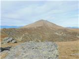
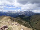
 | Bukovnik - Velika Raduha (via Durce)
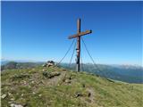
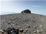
Velika Raduha, at 2062 m, is the highest peak of the Raduha range, which rises steeply east of Robanov Kot. From the summit, with its registratio...
2 h 50 min |
 | Planina Vodol - Velika Raduha
Velika Raduha, at 2062 m, is the highest peak of the Raduha range, which rises steeply east of Robanov Kot. From the summit, with its registratio...
2 h 40 min |
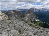
 | End of road on Vogar - Mala Tičarica (via Štapce)
Mala Tičarica is a highly panoramic mountain above the Twin Triglav Lakes. From the summit there is a beautiful view toward the Koča pri Triglavs...
3 h 30 min |
 | Kriška planina - Kalški greben (via planina Koren)
Kalški greben is a 2224 m high peak and the highest point of the ridge bearing the same name. From the summit, where there is a summit register a...
3 h 45 min |
| Dom na Gospincu - Kalški greben (via Dolga Njiva)
Kalški greben is a 2224 m high peak and the highest point of the ridge bearing the same name. From the summit, where there is a summit register a...
3 h 20 min |
 | Kraljev dol - Veliki vrh (Veža) (via Planina Vodole)
Veliki Vrh is a 2,110-metre-high mountain located in the central part of the Dleskovec Plateau. From the summit, where there are two registration...
2 h 35 min |
 | Waldheimhütte - Zirbitzkogel (via Wildsee)
Zirbitzkogel, at 2,396 m, is the highest peak of the Labotniške Alpe / Seetaler Alpen. From the summit, where a cross and a panorama board stand,...
3 h 32 min |
| Waldheimhütte - Zirbitzkogel (via Rothaidenhütte)
Zirbitzkogel, at 2,396 m, is the highest peak of the Labotniške Alpe / Seetaler Alpen. From the summit, where a cross and a panorama board stand,...
3 h 7 min |
| Waldheimhütte - Zirbitzkogel (via Lavantsee)
Zirbitzkogel, at 2,396 m, is the highest peak of the Labotniške Alpe / Seetaler Alpen. From the summit, where a cross and a panorama board stand,...
2 h 47 min |
 | Waldheimhütte - Fuchskogel (via Wildsee)
Fuchskogel is a peak south of Zirbitzkogel in the Seetaler Alpen mountain group. The summit is broad and mostly covered in grass. More precisely,...
2 h 45 min |
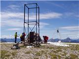
 | Waldheimhütte - Scharfes Eck (Direct way)
Scharfes Eck is a peak on which stands an Austrian meteorological radar station. From the summit, there is a beautiful view of the neighbouring p...
2 h 45 min |
| Tonnerhütte - Scharfes Eck
Scharfes Eck is a peak on which stands an Austrian meteorological radar station. From the summit, there is a beautiful view of the neighbouring p...
3 h |
 | Salzstiegelhaus - Großenberg (Packalpe) (via Ameringkogel)
Großenberg, also known as Größing, is the northernmost two-thousander in the Packalpe mountain group. From its expansive grassy summit, where a t...
3 h |
| Salzstiegelhaus - Großenberg (Packalpe)
Großenberg, also known as Größing, is the northernmost two-thousander in the Packalpe mountain group. From its expansive grassy summit, where a t...
2 h 55 min |
 | Nassfeld - Monte Cavallo / Rosskofel (via Sella di Aip / Rudnig sattel)
Konjski Špik / Monte Cavallo di Pontebba / Rosskofel is a 2,240-meter-high and highly panoramic mountain in the main ridge of the Carnic Alps in ...
4 h |
 | Waldrast - Großer Speikkogel (Koralpe) (via Großhöllerhütte)
Großer Speikkogel is, at 2,140 meters, the highest peak of Golica/Koralpe, a range east of Volšperk/Wolfsberg. From the summit, where a cross and...
3 h 45 min |
 | parking below Weinebene - Großer Speikkogel (Koralpe) (panoramic path)
Großer Speikkogel is, at 2,140 meters, the highest peak of Golica/Koralpe, a range east of Volšperk/Wolfsberg. From the summit, where a cross and...
3 h |
| parking below Weinebene - Großer Speikkogel (Koralpe) (via cross Schäferkreuz)
Großer Speikkogel is, at 2,140 meters, the highest peak of Golica/Koralpe, a range east of Volšperk/Wolfsberg. From the summit, where a cross and...
3 h 15 min |
| parking below Weinebene - Großer Speikkogel (Koralpe) (via Grünangerhütte)
Großer Speikkogel is, at 2,140 meters, the highest peak of Golica/Koralpe, a range east of Volšperk/Wolfsberg. From the summit, where a cross and...
3 h 10 min |
 | Weinebene - Großer Speikkogel (Koralpe) (above Pomswasserfall)
Großer Speikkogel is, at 2,140 meters, the highest peak of Golica/Koralpe, a range east of Volšperk/Wolfsberg. From the summit, where a cross and...
3 h 45 min |
| Waldrast - Großer Speikkogel (Koralpe) (by the edge of the Großes Kar plateau)
Großer Speikkogel is, at 2,140 meters, the highest peak of Golica/Koralpe, a range east of Volšperk/Wolfsberg. From the summit, where a cross and...
2 h 45 min |
 | Ladinger Straße - Ladinger Spitz (Saualpe) (via Ladinger Hütte)
Velika Svinja, known in German as Ladinger Spitz, is at 2079 m the highest peak of the Svinja / Saualpe mountain range. From the summit, which ha...
3 h |
 | Ladinger Straße - Ladinger Spitz (Saualpe) (via Wolfsberger Hütte)
Velika Svinja, known in German as Ladinger Spitz, is at 2079 m the highest peak of the Svinja / Saualpe mountain range. From the summit, which ha...
2 h 50 min |
 | Klippitztörl - Ladinger Spitz (Saualpe) (via Geierkogel and Gertrusk)
Velika Svinja, known in German as Ladinger Spitz, is at 2079 m the highest peak of the Svinja / Saualpe mountain range. From the summit, which ha...
4 h 10 min |
| Klippitztörl - Ladinger Spitz (Saualpe)
Velika Svinja, known in German as Ladinger Spitz, is at 2079 m the highest peak of the Svinja / Saualpe mountain range. From the summit, which ha...
3 h 35 min |
 | Etrachsee - Bauleiteck
Bauleiteck is a panoramic peak located on the eastern part of the Schladminger Tauern mountain group. From the summit, where a cross stands, ther...
3 h 15 min |
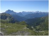
 | Passo Valparola - Lagazuoi Piccolo
Lagazuoi Piccolo is a 2,778 m high mountain located north of the Passo Falzarego pass (2,105 m). From the summit, where a cross stands, there is ...
2 h 45 min |
 | Rifugio Bai de Dones - Rifugio Nuvolau (Trincee)
The mountain hut Rifugio Nuvolau is located on its eponymous summit, southwest of Cortina d'Ampezzo. On clear days, it offers a breathtaking pano...
2 h 50 min |
| Rifugio Bai de Dones - Rifugio Nuvolau (via Rifugio Cinque Torri)
The mountain hut Rifugio Nuvolau is located on its eponymous summit, southwest of Cortina d'Ampezzo. On clear days, it offers a breathtaking pano...
2 h 35 min |
 | Jakobe - Feistritzer Spitze (easy path)
Bistriška špica is a 2113 m high peak located on the Austrian side of Peca. From the summit, which features a cross, there is a fine view of the ...
3 h 45 min |
 | Jakobe - Končnikov vrh (Peca) (easy path)
Končnikov vrh (German: Knieps) is a 2109 m high peak situated in the central part of Peca. From the grassy summit, there is a beautiful view of t...
2 h 45 min |
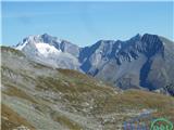
 | Volkzeinalm - Hochalmspitze (Villgraten)
Hochalmspitze is a 2797-meter-high peak located in the southwestern part of the High Tauern in the Villgraten mountain group. This peak is much l...
2 h 45 min |
 | Plockenpass - Creta di Collinetta / Cellon
Creta di Collinetta / Cellon is a 2,238-meter-high mountain located west of the Plöcken Pass. From the summit, which features a cross, there is a...
3 h |
 | Piano Fiscalino / Fischleinboden - Sasso di Sesto / Sextnerstein
Sasso di Sesto is a 2,539-meter-high peak located in the Sexten Dolomites Nature Park. This easily accessible peak offers exceptional views of th...
3 h 30 min |
 | Heidi Alm - Mallnock (via Klomnock)
Mallnock is a 2226 m high peak located north of the settlement St. Oswald in the Krške Alpe. From the summit, where a cross stands, a beautiful v...
2 h 45 min |
 | Malga Crocifisso - Sas de Adam
Sas de Adam (also Sass de Dama) is a 2,430-meter-high peak situated north of the alpine valley Val Sen Nicolo. From the top, a nice view opens up...
2 h 35 min |
 | Colfosco - Sas Ciampac
Sas Ciampac is a 2672-meter-high peak in the Puez group. From the summit, which features a small wooden cross, there is a nice view of the Puez g...
3 h 30 min |
 | Sadnighaus - Sadnig (direct way (path 150))
Sadnig or Hoher Sadnig is a relatively easily accessible and panoramic mountain in the eponymous Sadnig group (German: Sadniggruppe), the souther...
2 h 45 min |
 | Sadnighaus - Sadnig (via mountain pasture Lindler (pot 149))
Sadnig or Hoher Sadnig is a relatively easily accessible and panoramic mountain in the eponymous Sadnig group (German: Sadniggruppe), the souther...
3 h 15 min |
 | Sportgastein - Greilkopf (via Hagener Hütte)
Greilkopf is a 2,581 m high mountain in the Ankogel group of the Hohe Tauern in Austria above the town of Mallnitz. It is a popular winter destin...
3 h 45 min |
 | Turracher Höhe - Straßburger Spitz
Straßburger Spitz is a 2,404-meter-high peak located between the summits of Eisenhut (2,441 m) and Wintertalernock (2,394 m). From the top, where...
4 h 45 min |
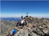
 | Thredbo - Mount Kosciuszko (Merritts Track & Mt. Kosciuszko Track)
Mount Kosciuszko is the highest mountain on mainland Australia, the easiest of the elite "Seven Summits", and it is also on the Ultra list. The m...
4 h |
 | Kühtai - Sulzkogel (normal approach from Kühtai)
Sulzkogel is a panoramic, easy, and relatively quickly accessible three-thousander located above the well-known ski center Kühtai in the Sellrain...
3 h 30 min |
 | Passo San Pellegrino - Col Margherita
Col Margherita is a 2,514-meter-high mountain rising above the San Pellegrino Pass in the Dolomites. Several cableways lead to it, and in the sum...
3 h |
 | Passo San Pellegrino - Cima Juribrutto
Cima Juribrutto is a 2,697-meter-high mountain rising above the San Pellegrino Pass. It offers a nice view also towards the Valles Pass....
3 h |
| Vitlenica - Veliki Vilinac (Vitlenica - Vilinac)
Veliki Vilinac is one of the peaks of the Čvrsnica mountain range, located west of Jablanica in Blidinje Nature Park. Čvrsnica is bounded by the ...
3 h |
 | Sella di Razzo - Clapsavon (via 210)
Clapsavon is a 2,462-meter-high mountain in the Carnic Alps in Italy. It lies about an hour's walk west of the 2,474-meter-high Bivera. Both peak...
3 h |
 | Lakkos tou Mygerou - Agathias (Kreta)
Agathias is the fourth-highest mountain on the island of Crete in Greece, at 2,424 meters. Agathias (Gr. Αγκαθιάς) is located southeast of Timios...
3 h |
 | Lakkos tou Mygerou - Timios Stavros / Psiloritis (Kreta)
Timios Stavros is Crete's highest mountain at 2,456 meters and also the highest among the Greek islands. Due to its topographic prominence, it is...
3 h |
 | parking below Weinebene - Krakaberg (Golica / Koralpe) (panoramic path)
Krakaberg is a 2,070-meter-high peak located south of Großer Speikkogel, the highest peak of Golica / Koralpe. From the summit, a nice view opens...
3 h 10 min |
 | parking below Weinebene - Steinschneider (above Pomswasserfall)
Steinschneider is a 2070-meter-high peak in the Golica / Koralpe mountain range, situated northwest of Großer Speikkogel, the highest peak of the...
3 h 20 min |