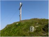
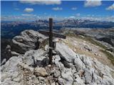
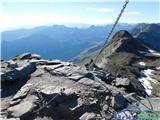
 | Sella Nevea - Prestreljenik (on ski track)
Prestreljenik is a 2,499 m high mountain located in the heart of the Kanin range. From the summit, where there is a registration box shaped like ...
3 h 30 min |
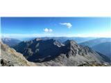
 | Ljubelj - Hochstuhl/Stol (upper way)
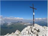
Stol is, at 2,236 m, the highest peak in the Karawanks. From the summit, which has a registration box and stamp, a beautiful view opens onto the ...
4 h 50 min |
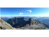
| Johannsenruhe - Hochstuhl/Stol (via Klagenfurter Hütte)
Stol is, at 2,236 m, the highest peak in the Karawanks. From the summit, which has a registration box and stamp, a beautiful view opens onto the ...
3 h 45 min |
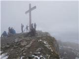
| Ljubelj - Hochstuhl/Stol (via Vatelca or Skleda)
Stol is, at 2,236 m, the highest peak in the Karawanks. From the summit, which has a registration box and stamp, a beautiful view opens onto the ...
5 h |
 | Ljubelj - Vertatscha/Vrtača
Vrtača is a 2181 m high peak located east of Stol. From the summit, where a large peg stands, a beautiful view opens over parts of the Julian Alp...
3 h 30 min |
| Tinčkova koča - Vertatscha/Vrtača (via Smuška planina in saddle Šija)
Vrtača is a 2181 m high peak located east of Stol. From the summit, where a large peg stands, a beautiful view opens over parts of the Julian Alp...
3 h 30 min |
| Trate / Johannsenruhe - Vertatscha/Vrtača
Vrtača is a 2181 m high peak located east of Stol. From the summit, where a large peg stands, a beautiful view opens over parts of the Julian Alp...
4 h |
 | Ljubelj - Prešernova koča na Stolu (upper way)
The Prešernova koča na Stolu mountain hut is located just a few metres below the summit of the 2198 m high Mali Stol. From the hut or the nearby ...
4 h 45 min |
| Ljubelj - Prešernova koča na Stolu (via Vatelca or Skleda)
The Prešernova koča na Stolu mountain hut is located just a few metres below the summit of the 2198 m high Mali Stol. From the hut or the nearby ...
4 h 55 min |
 | Trate / Johannsenruhe - Prešernova koča na Stolu (via Celovška koča)
The Prešernova koča na Stolu mountain hut is located just a few metres below the summit of the 2198 m high Mali Stol. From the hut or the nearby ...
3 h 40 min |
 | Ravenska Kočna - Ledinski vrh (hunter's way)
The mountain is located above Jezersko and lies on the border with Austria. From the summit there is a beautiful view north towards the neighbour...
3 h 30 min |
| Koča pod slapom Rinka - Ledinski vrh
The mountain is located above Jezersko and lies on the border with Austria. From the summit there is a beautiful view north towards the neighbour...
3 h 30 min |
 | Planina Blato - Mala Zelnarica (Za Kopico)
Mala Zelnarica is a 2310-meter-high peak situated between the Valley of the Triglav Lakes and the Za Kopico Valley. From the summit, which has a ...
4 h 15 min |
 | Planina Blato - Mala Zelnarica (via Štapce)
Mala Zelnarica is a 2310-meter-high peak situated between the Valley of the Triglav Lakes and the Za Kopico Valley. From the summit, which has a ...
5 h 10 min |
| End of road on Vogar - Mala Zelnarica (via Štapce)
Mala Zelnarica is a 2310-meter-high peak situated between the Valley of the Triglav Lakes and the Za Kopico Valley. From the summit, which has a ...
5 h 15 min |
 | Koča pod slapom Rinka - Velika (Koroška) Baba
Velika (Koroška) Baba is a 2127 m high mountain on the border ridge above the Ravenska Kočna valley on the Slovenian side and above the Bela (Bel...
4 h 30 min |
| Ravenska Kočna - Velika (Koroška) Baba (on hunting path and over Jezersko sedlo)
Velika (Koroška) Baba is a 2127 m high mountain on the border ridge above the Ravenska Kočna valley on the Slovenian side and above the Bela (Bel...
4 h 30 min |
 | Untere Valentinalm - Rauchkofel
North of Monte Coglians, the highest peak of the Carnic Alps, lies the 2,460-meter-high Rauchkofel. From the summit, which features a cross and a...
3 h 15 min |
| Untere Wolayeralm - Rauchkofel
North of Monte Coglians, the highest peak of the Carnic Alps, lies the 2,460-meter-high Rauchkofel. From the summit, which features a cross and a...
3 h 45 min |
| Rifugio Tolazzi - Rauchkofel
North of Monte Coglians, the highest peak of the Carnic Alps, lies the 2,460-meter-high Rauchkofel. From the summit, which features a cross and a...
3 h 15 min |
 | Raabtal - Monte Vancomun / Hochspitz
Monte Vancomun / Hochspitz is a 2,580-meter-high mountain located south of the upper Gail Valley. From the summit, which features a cross, there ...
3 h 15 min |
 | San Martino - Cima della Rosetta
Cima della Rosetta is a 2,743-meter-high peak rising above the settlement of San Martino. From the summit, where a cross stands, there is a nice ...
3 h 40 min |
 | Rifugio Pederü - Muntejela de Sennes
Muntejela de Sennes (Monte Sella di Sennes) is a 2,787-meter-high peak in the Fanes-Sennes-Prags Nature Park. The summit is located west of the M...
3 h 30 min |
| Rifugio Ra Stua - Muntejela de Sennes
Muntejela de Sennes (Monte Sella di Sennes) is a 2,787-meter-high peak in the Fanes-Sennes-Prags Nature Park. The summit is located west of the M...
3 h 30 min |
 | Klammbrückl - Weittalspitze
Weittalspitze is a 2539-meter-high peak in the Lienz Dolomites. The summit is located south of the Kerschbaumeralm pasture. From the top, where a...
3 h 30 min |
 | Colfosco - Piz de Puez / Puezspitz
Piz de Puez (eastern summit) is a 2,913-meter-high peak in the Puez mountain group. A marked path leads to the summit, which is relatively easy t...
4 h 45 min |
 | Kesselfall - Höhenburg
Höhenburg is a 2,108-metre mountain in the Glockner group of the High Tauern. It is located beside the Mooserboden reservoir. From the summit, wh...
3 h 50 min |
 | Rifugio Pederü - Col Bechei
Col Bechei (also Col Becchei, German Pareispitze, Italian Monte Parei) is a 2,794-meter-high peak above the Valle di Fanes and Valle di Rudo vall...
3 h 55 min |
| Capanna Alpina - Col Bechei
Col Bechei (also Col Becchei, German Pareispitze, Italian Monte Parei) is a 2,794-meter-high peak above the Valle di Fanes and Valle di Rudo vall...
4 h 15 min |
 | Parking below Jamnigalm - Vordere Geislspitze / Vorderer Gesselkopf
Vordere Geislspitze (also Geiselspitze) is a mountain in the Hohe Tauern in Austria, in the Goldberge group. The mountain name has numerous varia...
4 h 30 min |
 | Sportgastein - Vordere Geislspitze / Vorderer Gesselkopf (via Hagener Hütte)
Vordere Geislspitze (also Geiselspitze) is a mountain in the Hohe Tauern in Austria, in the Goldberge group. The mountain name has numerous varia...
5 h 15 min |
 | Parking below Jamnigalm - Hinterer Geißlkopf
Hinterer Geißlkopf (also known as Geiselkopf / Geisslkopf / Geiselspitze) is a 2,888-meter-high mountain in the Goldberg range of the Hohe Tauern...
4 h 40 min |
 | Sportgastein - Hinterer Geißlkopf (via Hagener Hütte)
Hinterer Geißlkopf (also known as Geiselkopf / Geisslkopf / Geiselspitze) is a 2,888-meter-high mountain in the Goldberg range of the Hohe Tauern...
5 h 15 min |
 | Collina - Cima Ombladet (path 141)
Cima Ombladet is a 2,255-meter-high mountain in the Carnic Alps east of the town of Forni Avoltri. From the summit, where a small cross stands, t...
3 h 20 min |
 | Maria Waldrast - Serles (western approach from Maria Waldrast)
Serles is one of the most recognizable, admired, and visited peaks around Innsbruck. This three-headed pyramidal mountain, together with Hafeleka...
3 h 30 min |
 | Tri studničky - Kriváň
Mount Kriváň is the first prominent peak of the High Tatras when viewed from the west and belongs to Tatra National Park. It rises above the Lipt...
4 h |
 | Crno polje - Zelena glava
Zelena glava is the highest peak of the Prenj mountain range, located in northern Herzegovina south of Konjic and north of Mostar. From the summi...
4 h |
 | Parkplatz Tappenkarweg - Weißgrubenkopf (Parkplatz Tappenkarweg - Weißgrubenkopf)
Weißgrubenkopf is a 2,369-meter-high panoramic mountain at the far west of the Lower Tauern in the Austrian state of Salzburg. It is located dire...
3 h 30 min |
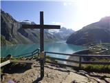
| Koča pod slapom Rinka - Skuta Glacier
Ledenik pod Skuto is today the largest glacier in Slovenia. Due to its location, it is in good condition and has been slightly expanding accordin...
4 h 10 min |