 | Vače - Zasavska Sveta gora
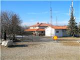
Zasavska Sveta Gora is a popular excursion destination located between Litija and Izlake. From the summit, where the parish church of the Nativit...
2 h |
 | Rovte - Vrh Svetih Treh Kraljev (steep path)
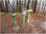
The Church of the Holy Three Kings stands on a panoramic hill above the village of Vrh Svetih Treh Kraljev. The summit features a panorama board ...
1 h 25 min |
| Rovte - Vrh Svetih Treh Kraljev (gentle path)
The Church of the Holy Three Kings stands on a panoramic hill above the village of Vrh Svetih Treh Kraljev. The summit features a panorama board ...
1 h 30 min |
 | Dom na Goropekah - Vrh Svetih Treh Kraljev
The Church of the Holy Three Kings stands on a panoramic hill above the village of Vrh Svetih Treh Kraljev. The summit features a panorama board ...
1 h 40 min |
| Sopot - Vrh Svetih Treh Kraljev
The Church of the Holy Three Kings stands on a panoramic hill above the village of Vrh Svetih Treh Kraljev. The summit features a panorama board ...
1 h 25 min |
 | Zaplana (Prezid) - Koča na Planini nad Vrhniko
Planina nad Vrhniko is for Vrhnika locals something like Šmarna gora for those from Ljubljana. It is 733 m high, reachable by several paths from ...
1 h 40 min |
 | Zaplana (Prezid) - Ulovka
Ulovka is a peak between Zaplana and Zavetišče na Planini nad Vrhniko. From the summit, to which ski lifts run, there is a nice view to the north...
1 h 45 min |
 | Podmeja - Reška planina (on ridge)
Reška planina is a peak in the Posavsko hribovje, located southwest of Prebold. The summit is in the forest and marked by a sign on a tree; it li...
2 h 5 min |
 | Zagreben (pri Dikcu) - Malič
Malič is a 936-meter-high peak situated between Celje and Laško, more precisely above Spodnja Rečica. From the summit, which has a transmitter, b...
1 h 30 min |
 | Lokev - Kokoš
The Koča na Kokoši mountain hut is located on Jirmanec peak, just 5 minutes from the forested Kokoš. From the summit, situated south of Lokavsko ...
1 h 30 min |
 | Lokev - Kokoš (via source of Vroček)
The Koča na Kokoši mountain hut is located on Jirmanec peak, just 5 minutes from the forested Kokoš. From the summit, situated south of Lokavsko ...
2 h |
 | Krvavi Potok - Kokoš
The Koča na Kokoši mountain hut is located on Jirmanec peak, just 5 minutes from the forested Kokoš. From the summit, situated south of Lokavsko ...
1 h 30 min |
| Prelože pri Lokvi - Kokoš
The Koča na Kokoši mountain hut is located on Jirmanec peak, just 5 minutes from the forested Kokoš. From the summit, situated south of Lokavsko ...
1 h 30 min |
 | Blečji vrh - Gradišče (via Kucelj)
Gradišče is a lesser-known peak situated north of Višnja gora. From the summit, where a large cross stands, there is a nice view of the surroundi...
1 h 30 min |
 | Hrpelje - Hrpeljska gora
Hrpeljska gora, also known as Mišja šoga, is a 737-meter-high peak located south of Hrpelje. From its partly vegetated summit, there are beautifu...
1 h 30 min |
 | Zagrad - Mala Plešivica
Mala Plešivica, which is higher than the neighboring Velika Plešivica, is an exceptionally scenic peak west of the village of Golac, right on the...
1 h 30 min |
 | Velike Lašče - Kamen vrh (via Gornje Retje and Grmada)
Kamen Vrh is a panoramic hill located on the northern edge of Mala Gora. From the summit, surrounded by low bushes, there are fine views of parts...
2 h 35 min |
 | Velike Lašče - Grmada on Mala gora (via Gornje Retje)
Grmada (also Grmada above Ortnek) is an 887-meter-high peak located above the village of Vrh pri Poljanah in the Mala Gora range. Just a few mete...
2 h |
 | Suhi Dol - Sivka (through forest)
Sivka is a grassy peak at the far western end of Polhograjsko hribovje. On clear days, it offers breathtaking views from Snežnik across Javorniki...
1 h 30 min |
| Suhi Dol - Sivka (by road)
Sivka is a grassy peak at the far western end of Polhograjsko hribovje. On clear days, it offers breathtaking views from Snežnik across Javorniki...
1 h 40 min |
 | Veliki Boč (Zgornji Kovač) - Žavcarjev vrh
Žavcarjev vrh is a 915 m high mountain located north of the Drava River on the slopes of Kozjak. Since the summit is completely forested, there i...
1 h 25 min |
 | Zavrh pri Trojanah - Golčaj
Golčaj is a 690 m high hill rising south of Blagovica. At the summit, which has a logbook box and stamp, stands a NOB monument; a few tens of met...
2 h 30 min |
 | Mislinja - Fričev vrh (via Črepič)
Fričev vrh is an 881 m high hill located south of Mislinjska Dobrava. From the summit, which has a logbook box with book and stamp inside, there ...
1 h 35 min |
 | Mislinja - Fričev vrh (via Završe)
Fričev vrh is an 881 m high hill located south of Mislinjska Dobrava. From the summit, which has a logbook box with book and stamp inside, there ...
2 h |
 | Mislinja - Sveti Rupert (Završe)
The Church of St. Rupert (Završe) is located on a panoramic rise south of Fričev vrh. In good weather, from the church or its nearby surroundings...
1 h 25 min |
 | Čepulje - Sveti Mohor (Zabrekve)
The Church of St. Mohor is located on a 952 m high hill between Zgornja Besnica and Selci. From the church or its nearby surroundings, there is a...
1 h 30 min |
 | Pivka - Šilentabor
Šilentabor is a 751-meter-high peak just above the village of the same name. From the summit, near which there is a bench and a logbook box, ther...
1 h 30 min |
 | Planina pri Sevnici - Brest (Bohor) (northern path)
Brest is a peak on Bohor, though it resembles more of a saddle. It is an important trail junction on Bohor, lying between more easterly Oslica an...
2 h 20 min |
| Šentvid pri Planini - Brest (Bohor) (northern path)
Brest is a peak on Bohor, though it resembles more of a saddle. It is an important trail junction on Bohor, lying between more easterly Oslica an...
1 h 50 min |
 | Bašelj - Gradišče (Pustinjak) (via Sveti Lovrenc)
Gradišče or Pustinjak (also Gradišče nad Bašljem) is an 871-meter-high peak located above the Belica stream, which lies below the 2,132-meter-hig...
1 h 30 min |
 | Travnarjev gozd (Hotenjsko podolje) - Šenčurjev vrh
Šenčurjev vrh is a 725-meter-high hill located above the settlement of Žibrše, which lies between Logatec, Hotedršica, and Rovte. At the summit, ...
1 h 50 min |
 | Ravne - Loška stena
Loška stena rises above Zgornja Kolpska dolina, more precisely above the villages of Grintovec pri Osilnici, Ložec, and Ribjek. From the summit o...
1 h 50 min |
 | border crossing Remšnik - Tolsti vrh (on Kozjak) (Slovenian way)
Tolsti vrh is a 756-meter-high peak on Kozjak, located on the Austria-Slovenia border north of Zgornja Kapla settlement. The summit lies in fores...
2 h 30 min |
 | Rein - Pfaffenkogel
Pfaffenkogel is a 734 m high hill in the western part of the Grazer Bergland in Austrian Styria. The summit is located north of the town of Gratw...
1 h 30 min |
 | Male Drage - Okrugljak (via Razdrto)
Okrugljak is a forested hill located in the eastern part of Gorski Kotar, near the border with Slovenia. The summit was formerly an HPO point (no...
2 h 30 min |
| Male Drage - Okrugljak
Okrugljak is a forested hill located in the eastern part of Gorski Kotar, near the border with Slovenia. The summit was formerly an HPO point (no...
1 h 30 min |
 | Brest - Špičasti vrh (pri Žbevnici) (gentle path)
Pointed Peak is a scenic grassy peak along the marked path between Golič and Žbevnica, near the Slovenian border. The peak has a summit book box ...
1 h 25 min |