 | Dom na Govejku - Tošč
Tošč, which became the highest peak of the Polhov Gradec Hills decades ago when the Yugoslav army lowered Pasja ravan by 9 metres, is located nor...
1 h 45 min |
 | Mesnice - Krim (by road)
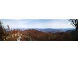
Krim is a 1,107-metre-high mountain rising south of the Ljubljana Marsh. From the summit, where a mountain hut and several transmitters stand, th...
1 h 50 min |
 | Rakitna - Krim
Krim is a 1,107-metre-high mountain rising south of the Ljubljana Marsh. From the summit, where a mountain hut and several transmitters stand, th...
2 h |
 | Polharski dom Krim - Krim
Krim is a 1,107-metre-high mountain rising south of the Ljubljana Marsh. From the summit, where a mountain hut and several transmitters stand, th...
1 h 35 min |
 | Furlanovo zavetišče pri Abramu - Vojkova koča na Nanosu
Vojkova koča is located on the southern edge of the high karst Nanos plateau, near Pleša. This is the prominent peak with television transmitters...
2 h |
 | Polomova rajda - Kucelj (on Čaven) (by road)
Kucelj is located on the southern slopes of the Trnovski Forest, northwest of the Vipava Valley. From the bare summit, where a cross stands, ther...
1 h 45 min |
 | Krnica - Kucelj (on Čaven) (via Veliki Rob)
Kucelj is located on the southern slopes of the Trnovski Forest, northwest of the Vipava Valley. From the bare summit, where a cross stands, ther...
1 h 40 min |
 | Dom na Goropekah - Vrh Svetih Treh Kraljev
The Church of the Holy Three Kings stands on a panoramic hill above the village of Vrh Svetih Treh Kraljev. The summit features a panorama board ...
1 h 40 min |
 | Repna dolina - Javornik (above Črni Vrh)
Javornik is a forested peak located southeast of Črni Vrh. In 1972, a wooden observation tower was built on it, rising above the treetops and off...
1 h 45 min |
 | Vodice (Mali Školj) - Javornik (above Črni Vrh)
Javornik is a forested peak located southeast of Črni Vrh. In 1972, a wooden observation tower was built on it, rising above the treetops and off...
1 h 35 min |
 | Predmeja - Navrše (Pot po Robu)
Navrše is a little-known peak southeast of Otliško okno. It offers nice views of the Vipava Valley and the peaks surrounding it....
2 h 15 min |
 | Predmeja - Otliški maj (Pot po Robu)
Otliški maj is a panoramic peak south of Otlica. It offers nice views of the Vipava Valley, Čavna slopes, Golaki (with the vast Trnovski gozd vis...
1 h 45 min |
 | Govejk - Sivka
Sivka is a forested peak located west of Žiri and north of Idrija. At the summit there is a stamp for the Slovenian Mountain Trail and a logbook ...
1 h 40 min |
 | Podmeja - Reška planina (on ridge)
Reška planina is a peak in the Posavsko hribovje, located southwest of Prebold. The summit is in the forest and marked by a sign on a tree; it li...
2 h 5 min |
 | Uglov laz - Koča na Kamnem griču (via Dom na Travni Gori)
The Koča na Kamnem griču mountain hut is located on Kamni grič, a panoramic hill rising southwest of Sodražica. From the grassy summit surrounded...
2 h |
 | Dom na Čreti - Tolsti vrh (Dobrovlje)
Tolsti vrh, together with Šentjoški vrh (1,077 m), is the highest peak of the Dobroveljska planota plateau. From the summit, which has a logbook ...
1 h 45 min |
 | Podlanišče - Ermanovec
Ermanovec is a 1,026-meter-high peak situated between Cerkno and Gorenja vas, more precisely above Sovodenj and Trebija. Just a few steps from th...
1 h 35 min |
 | Zagrad - Medvižica (via Ostrič)
Medvižica is a rocky peak located on the Slovenian side of Čičarija. From the bare summit, there is a beautiful view of the surrounding hills, wi...
1 h 50 min |
| Zagrad - Medvižica (via Razsušica)
Medvižica is a rocky peak located on the Slovenian side of Čičarija. From the bare summit, there is a beautiful view of the surrounding hills, wi...
1 h 45 min |
 | Suhi Dol - Sivka (by road)
Sivka is a grassy peak at the far western end of Polhograjsko hribovje. On clear days, it offers breathtaking views from Snežnik across Javorniki...
1 h 40 min |
 | Strma Reber - Cerk
Cerk, at 1,192 meters, is the highest peak of Borovška gora, a range situated between the Kolpa River valley and Goteniški Snežnik. From the summ...
1 h 45 min |
 | Mislinja - Fričev vrh (via Črepič)
Fričev vrh is an 881 m high hill located south of Mislinjska Dobrava. From the summit, which has a logbook box with book and stamp inside, there ...
1 h 35 min |
 | Mislinja - Fričev vrh (via Završe)
Fričev vrh is an 881 m high hill located south of Mislinjska Dobrava. From the summit, which has a logbook box with book and stamp inside, there ...
2 h |
 | Podblica - Sveti Mohor (Zabrekve)
The Church of St. Mohor is located on a 952 m high hill between Zgornja Besnica and Selci. From the church or its nearby surroundings, there is a...
1 h 40 min |
 | Govejk - Loncmanova Sivka (Mrzli Vrh)
Loncmanova Sivka is a panoramic peak above the village Mrzli Vrh near Žiri. From the bare summit, on clear days, there are views of Golaki, Škofj...
1 h 40 min |
 | Solarji - Nagnoj
Nagnoj is the second-highest peak of the Kolovrat range at 1193 m. The range lies between Tolmin and Venetian Slovenia. From the summit, which ha...
1 h 40 min |
 | Ravne - Loška stena
Loška stena rises above Zgornja Kolpska dolina, more precisely above the villages of Grintovec pri Osilnici, Ložec, and Ribjek. From the summit o...
1 h 50 min |
 | Sovodenj - Planinska koča Mrzl'k
The Planinska koča Mrzl'k mountain hut lies just a few meters below the Mrzlik summit. From the hut opens up a fine view of the neighboring Mrzli...
1 h 40 min |
| Govejk - Planinska koča Mrzl'k
The Planinska koča Mrzl'k mountain hut lies just a few meters below the Mrzlik summit. From the hut opens up a fine view of the neighboring Mrzli...
1 h 40 min |
 | Sveta Katarina (Zgornja Kapla) - Sveti Pankracij (Radelca) (Austrian way)
The Church of St. Pankracij on Radelca lies on the border ridge between Slovenia and Austria; since 1966, following an interstate agreement, it h...
2 h 45 min |
 | Gornje Jelenje - Tuhobić (mountain path on Tuhobić)
Tuhobić is a 1109-meter-high peak from which beautiful views open in all directions, with the best sights of Risnjak, Snježnik, Veliki Snežnik, U...
1 h 50 min |
 | Široko - Veliki vrh (above Lom) (via Grudnica - on trail Lom is my home)
Veliki vrh is located on the northeastern part of the Banjška planota plateau, which rises above Čepovani dol, the Soča river valley, and the Idr...
1 h 50 min |
 | Chortata - Egklouvi road - Stavrota (Lefkada)
Stavrota is the highest peak at 1,182 m on the Greek island of Lefkada (also known as Lefkas), which lies in the Ionian Sea. The Greek name of t...
1 h 50 min |
 | Malovan - Čardak (Tremzina)
Čardak is a peak on Tremzina, a smaller range east of the more famous Crnopac. Tremzina is located at the end of the Southern Velebit. There is a...
2 h |
 | Omar - Črni vrh (above Klenovica)
Črni vrh is a distinct peak situated above Klenovica. It is located near the more famous Kolovratske stijene. From the summit, which has a logboo...
1 h 45 min |