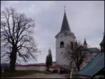
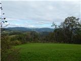
 | Topol - Sveti Jakob
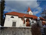
The Church of St. James is located on a scenic hill north of the village of Topol pri Medvodah. From the summit, which features a registration bo...
40 min |
| Topol - Sveti Jakob (via homestead Na Vihri)
The Church of St. James is located on a scenic hill north of the village of Topol pri Medvodah. From the summit, which features a registration bo...
45 min |
 | Rovišče - Zasavska Sveta gora (by road)
Zasavska Sveta Gora is a popular excursion destination located between Litija and Izlake. From the summit, where the parish church of the Nativit...
35 min |
 | Topol - Jeterbenk
Jeterbenk is a 774-meter-high peak located between the Slavkov dom hut on Golo Brdo and Katarina (the village of Topol). From the summit, where t...
45 min |
 | Praproče - Mali vrh
West of Polhov Gradec, between the rivers Mala voda and Velika Božna, lies the 708-meter-high hill known as Mali vrh. From the grassy summit, whi...
35 min |
 | Križna Gora - Archangel Gabriel (Planica)
Planica is an 824-meter-high peak located north of Škofja Loka, more precisely between Križna gora and Planica. From the summit, where the church...
35 min |
 | Čepulje - Archangel Gabriel (Planica)
Planica is an 824-meter-high peak located north of Škofja Loka, more precisely between Križna gora and Planica. From the summit, where the church...
50 min |
 | Smrečje - Vrh Svetih Treh Kraljev (by road)
The Church of the Holy Three Kings stands on a panoramic hill above the village of Vrh Svetih Treh Kraljev. The summit features a panorama board ...
45 min |
 | Smrečje - Vrh Svetih Treh Kraljev (footpath)
The Church of the Holy Three Kings stands on a panoramic hill above the village of Vrh Svetih Treh Kraljev. The summit features a panorama board ...
40 min |
| Smrečje - Vrh Svetih Treh Kraljev (via Jereb)
The Church of the Holy Three Kings stands on a panoramic hill above the village of Vrh Svetih Treh Kraljev. The summit features a panorama board ...
45 min |
 | Zaplana (St. Urh and St. Martin) - Ulovka
Ulovka is a peak between Zaplana and Zavetišče na Planini nad Vrhniko. From the summit, to which ski lifts run, there is a nice view to the north...
50 min |
 | Zagreben (pri Dikcu) - Dom na Šmohorju
The mountain lodge on Šmohor is located on a picturesque and scenic ridge between Laško, Liboje and Zabukovica. The lodge, a popular spot for bot...
45 min |
 | Sveta Gora - Vodice
Vodice (according to some records also Sveti Jakob) is a peak on the western part of the Banjška planota plateau. From the summit, which features...
45 min |
 | Tržič - Sveti Jurij above Tržič
The Church of St. Jurij, built in the 15th century, stands on a small hill above Tržič or Bistrica pri Tržiču. Nearby Gutenberg Castle, to which ...
40 min |
 | Lokev - Stari tabor
Stari Tabor is a panoramic peak located west of Divača, north of Lokev, and south of the village of Povir. From the summit, which has a stamp and...
45 min |
 | Križevska vas - Murovica (circular path)
Murovica is a popular excursion point, accessible from the Posavje side, Domžale, or the Moravška Valley. On the summit there is a bench and a lo...
50 min |
 | Križevska vas - Murovica
Murovica is a popular excursion point, accessible from the Posavje side, Domžale, or the Moravška Valley. On the summit there is a bench and a lo...
45 min |
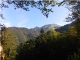
 | Zavratec - Medvedje Brdo
Medvedje Brdo is a small settlement located north of Hotedršica. The highest point of the village is a pleasant viewpoint on Šinkovcov grič (814 ...
45 min |
 | Dom na Govejku - Gontarska planina
Gontarska Planina is a 894-meter-high hill located between Osolnik and Tošč. From the summit, which features two benches, a splendid view opens t...
35 min |
 | Belo - Goljek
Goljek is an 809 m high peak located east of Polhograjska Grmada. From the summit, where remains of a former guard tower on the Italian-German bo...
40 min |
 | Čepulje - Špičasti hrib
Špičasti hrib (known as Špičasti vrh on maps) is an 837-meter-high hill located west of Sveti Jošt above Kranj. The summit, which has a few bench...
40 min |
 | Podlanišče - Veliki vrh (Lajše)
Veliki vrh is an almost 900-meter-high elevation rising south of Cerkno. From the summit, which features several television and radio transmitter...
40 min |
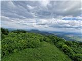
 | Hunting sports association Vinska Gora - Vinska gora
Vinska gora (marked as the neighboring Temnjak on some maps) is an 806 m high hill located northwest of Dobrna and northeast of Vinska Gora. From...
40 min |
 | Srednje - Globočak
Globočak is an 809 m high peak located in the Kanal Kolovrat range. From the summit, which has some remnants from the First World War, there is n...
35 min |
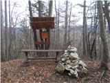
 | Zagorje - Šilentabor
Šilentabor is a 751-meter-high peak just above the village of the same name. From the summit, near which there is a bench and a logbook box, ther...
35 min |
 | Dragonoš (Krpesovka) - Japetić
Japetić is the highest peak of the Samoborsko gorje. It is located in its western part and serves as the local mountain for the town of Jastrebar...
45 min |
 | Preddvor - Novi grad (Pusti grad)
Novi grad or Pusti grad (German: Neuburg) is first mentioned in 1156. Today, only ruins remain of the castle, which is located on a hill north to...
40 min |
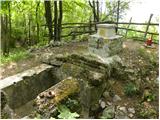
 | Veliko Trebeljevo - Sveta Marjeta (Prežganje)
The Church of St. Marjeta stands on the hilltop above Prežganje. Next to the church is the Minorite retreat house, and a bit lower down the Marje...
40 min |
 | Travnarjev gozd (Hotenjsko podolje) - Sveta Barbara (Ravnik pri Hotedršici)
The Church of St. Barbara is located on a panoramic rise above the settlement of Ravnik pri Hotedršici. From the church or its immediate surround...
35 min |
 | Možjanca - Apnišče
Apnišče is a 740 m high mountain between Možjanca and Štefanja gora. It is the highest point of the Šenčur municipality. The forested summit offe...
35 min |
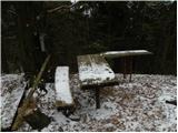
 | Čatež - Bajturn (Zaplaški hrib) (on ridge)
Bajturn, or Zaplaški hrib, at 609 meters, is the highest peak in the Trebnje municipality. The summit features a pleasant bench with a table, a b...
40 min |
| Čatež - Bajturn (Zaplaški hrib) (on north slope)
Bajturn, or Zaplaški hrib, at 609 meters, is the highest peak in the Trebnje municipality. The summit features a pleasant bench with a table, a b...
50 min |
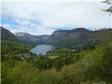 | Jezersko polje - Peč (viewpoint)
The viewpoint is located about 50 vertical meters below the 720-meter-high Peč peak, which separates the Lower from the Upper Bohinj Valley on th...
35 min |
 | Pečar - Žagarski vrh
Žagarski vrh is situated on the ridge between Podlipoglav and Besnica. From the summit, where there is the amateur radio operators' hut, there is...
35 min |
 | Aussichtswarte Vulkanland - Stradner Kogel
Stradner Kogel is the highest hill in southeastern Styria, Austria. The hill is of volcanic origin, and the summit offers no views in any directi...
45 min |
 | Zajasovnik - del (Strmce, chapel) - Jasovnik (Motnik tourist trail)
Jasovnik is a hill better known to everyone as the A1 highway tunnel. It lies near Trojane and has two peaks: Mali Jasovnik and Jasovnik. The sum...
45 min |
| Stružnica - Kuželjska stena
Kuželjska stena rises mightily above the village of Kuželj in the Kolpa River valley. It is a hill at a slope break, winding above the upper Kolp...
45 min |
 | Rašpor - Gradina Rašpor (on marked path)
Gradina Rašpor are the ruins of a former castle above the village of Rašpor. Several information boards are by the ruins. Due to the surrounding ...
45 min |