 | Railway station Hochzirl - Kleiner Solstein (on Höttinger Schützensteig)
Kleiner Solstein is the highest peak of the famous Nordkette ridge, which blocks views from the valley to the central part of the Karwendel range...
6 h |
 | Zadnja Trenta (Flori) - Jalovec (via Jalovška škrbina)
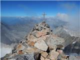
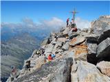
At 2,645 m, Jalovec is the sixth highest mountain in Slovenia. The summit drops steeply towards three alpine valleys (Loška Koritnica, Tamar, and...
5 h 40 min |
| Zadnja Trenta (Flori) - Jalovec (via Zavetišče pod Špičkom)
At 2,645 m, Jalovec is the sixth highest mountain in Slovenia. The summit drops steeply towards three alpine valleys (Loška Koritnica, Tamar, and...
5 h 45 min |
| Vršič - Jalovec (via Zavetišče pod Špičkom)
At 2,645 m, Jalovec is the sixth highest mountain in Slovenia. The summit drops steeply towards three alpine valleys (Loška Koritnica, Tamar, and...
6 h |
 | NC Planica - Jalovec (past bivouac and Kotovo sedlo)
At 2,645 m, Jalovec is the sixth highest mountain in Slovenia. The summit drops steeply towards three alpine valleys (Loška Koritnica, Tamar, and...
6 h 10 min |
| NC Planica - Jalovec (via Jalovška škrbina)
At 2,645 m, Jalovec is the sixth highest mountain in Slovenia. The summit drops steeply towards three alpine valleys (Loška Koritnica, Tamar, and...
6 h 30 min |
| NC Planica - Jalovec (on scree and over Kotovo sedlo)
At 2,645 m, Jalovec is the sixth highest mountain in Slovenia. The summit drops steeply towards three alpine valleys (Loška Koritnica, Tamar, and...
6 h 10 min |
 | parking lot Stupfer in Gaistal - Hohe Munde - western peak (on climbing path via western ridge)
Hohe Munde is a peak in the Mieming range west of Innsbruck and the local mountain of the town of Telfs, appearing as an imposing rock fortress a...
6 h 15 min |
 | Rio Bianco - Viš/Jof Fuart (Sentiero del Centenario)
Viš is a 2,666 m high peak in the western Julian Alps. From the summit, which features a statue of St. Mary and a cross beside it, there are fine...
6 h |
| Cave del Mole - Viš/Jof Fuart (Anita Goitan)
Viš is a 2,666 m high peak in the western Julian Alps. From the summit, which features a statue of St. Mary and a cross beside it, there are fine...
5 h 30 min |
 | Pri Mlinču - Mangart (slovenska pot)
Mangart (also spelled Mangrt; both forms are grammatically correct) is a mountain that attracts a large number of visitors in summer. Access to t...
4 h 45 min |
 | Klammbrückl - Spitzkofel
Spitzkofel is a 2717-meter-high mountain in the Lienz Dolomites. From the summit, where a large cross stands, there is a very nice view of the en...
5 h |
 | Aljažev dom v Vratih - Mali Triglav (via Prag)
Mali Triglav is an indistinct summit on the main ridge of Triglav. Despite its considerable height, it is rarely chosen as an independent objecti...
5 h 45 min |
| The Kot Valley - Mali Triglav
Mali Triglav is an indistinct summit on the main ridge of Triglav. Despite its considerable height, it is rarely chosen as an independent objecti...
5 h 50 min |
| Aljažev dom v Vratih - Mali Triglav (Tominšek route)
Mali Triglav is an indistinct summit on the main ridge of Triglav. Despite its considerable height, it is rarely chosen as an independent objecti...
5 h 35 min |
| The Krma Valley - Mali Triglav (via Kredarica)
Mali Triglav is an indistinct summit on the main ridge of Triglav. Despite its considerable height, it is rarely chosen as an independent objecti...
5 h 40 min |
| The Krma Valley - Mali Triglav (past Doma Planika pod Triglavom)
Mali Triglav is an indistinct summit on the main ridge of Triglav. Despite its considerable height, it is rarely chosen as an independent objecti...
5 h 25 min |
| Rudno polje - Mali Triglav (via Dom Planika)
Mali Triglav is an indistinct summit on the main ridge of Triglav. Despite its considerable height, it is rarely chosen as an independent objecti...
5 h 50 min |
| Rudno polje - Mali Triglav (via Kredarica)
Mali Triglav is an indistinct summit on the main ridge of Triglav. Despite its considerable height, it is rarely chosen as an independent objecti...
6 h 5 min |
| end of road on Pokljuka - Mali Triglav (via Planika)
Mali Triglav is an indistinct summit on the main ridge of Triglav. Despite its considerable height, it is rarely chosen as an independent objecti...
5 h 25 min |
| end of road on Pokljuka - Mali Triglav (via Kredarica)
Mali Triglav is an indistinct summit on the main ridge of Triglav. Despite its considerable height, it is rarely chosen as an independent objecti...
5 h 40 min |
| Uskovnica (Razpotje) - Mali Triglav (via Planika)
Mali Triglav is an indistinct summit on the main ridge of Triglav. Despite its considerable height, it is rarely chosen as an independent objecti...
5 h 55 min |
 | Aljažev dom v Vratih - Škrlatica
Škrlatica is the second highest mountain in Slovenia. A cross stands on the summit, making it easily recognisable from neighbouring peaks. It als...
6 h |
 | Plockenpass - Pilastro del Coglians
Pilastro del Coglians is a 2,750-metre peak east of Monte Coglians on the Austria-Italy border. A summit logbook is located on the compact summit...
4 h 30 min |
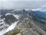
 | Planina Zajzera - Jôf di Montasio/Montaž (Via Amalia)
Montaž is one of the most imposing and, at 2,753 m, the second-highest mountain in the Julian Alps. Its authentic Slovenian name is Špik nad Poli...
6 h 45 min |
 | Plöckenpass - Creta della Chianevate / Kellerspitzen (path 171)
Creta della Chianevate (German: Kellerspitzen) is a 2,769-meter peak in the central Carnic Alps on the AustriaItaly border. From the summit, mark...
4 h 50 min |
| Plöckenpass - Creta della Chianevate / Kellerspitzen (via Cresta Verde)
Creta della Chianevate (German: Kellerspitzen) is a 2,769-meter peak in the central Carnic Alps on the AustriaItaly border. From the summit, mark...
5 h |
 | Sant'Uberto - Furcia Rossa III
Furcia Rossa III is a 2,791-meter-high peak in a somewhat more remote ridge along which the Walk of Peace (Fridensweg / Via della Pace) runs. At ...
5 h 15 min |
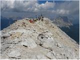
 | Aljažev dom v Vratih - Triglav (Tominšek route)
Triglav is a 2,864 m high mountain located in the heart of the Julian Alps. At this altitude, it is the highest mountain in Slovenia and also the...
6 h 10 min |
| Aljažev dom v Vratih - Triglav (via Prag)
Triglav is a 2,864 m high mountain located in the heart of the Julian Alps. At this altitude, it is the highest mountain in Slovenia and also the...
6 h 20 min |
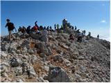 | Aljažev dom v Vratih - Triglav (via Plemenice)
Triglav is a 2,864 m high mountain located in the heart of the Julian Alps. At this altitude, it is the highest mountain in Slovenia and also the...
6 h 30 min |
| The Kot Valley - Triglav
Triglav is a 2,864 m high mountain located in the heart of the Julian Alps. At this altitude, it is the highest mountain in Slovenia and also the...
6 h 25 min |
| The Krma Valley - Triglav (via Kredarica)
Triglav is a 2,864 m high mountain located in the heart of the Julian Alps. At this altitude, it is the highest mountain in Slovenia and also the...
6 h 15 min |
| The Krma Valley - Triglav (via Planika and Mali Triglav)
Triglav is a 2,864 m high mountain located in the heart of the Julian Alps. At this altitude, it is the highest mountain in Slovenia and also the...
6 h |
 | The Krma Valley - Triglav (via Planika and Triglavska škrbina)
Triglav is a 2,864 m high mountain located in the heart of the Julian Alps. At this altitude, it is the highest mountain in Slovenia and also the...
5 h 55 min |
| end of road on Pokljuka - Triglav (via Kredarica)
Triglav is a 2,864 m high mountain located in the heart of the Julian Alps. At this altitude, it is the highest mountain in Slovenia and also the...
6 h 15 min |
| end of road on Pokljuka - Triglav (via Planika and Mali Triglav)
Triglav is a 2,864 m high mountain located in the heart of the Julian Alps. At this altitude, it is the highest mountain in Slovenia and also the...
6 h |
| Uskovnica (Razpotje) - Triglav (via Planika and Mali Triglav)
Triglav is a 2,864 m high mountain located in the heart of the Julian Alps. At this altitude, it is the highest mountain in Slovenia and also the...
6 h 30 min |
| Uskovnica (Razpotje) - Triglav (via Triglavska škrbina)
Triglav is a 2,864 m high mountain located in the heart of the Julian Alps. At this altitude, it is the highest mountain in Slovenia and also the...
6 h 25 min |
| end of road on Pokljuka - Triglav (via Planika and Triglavska škrbina)
Triglav is a 2,864 m high mountain located in the heart of the Julian Alps. At this altitude, it is the highest mountain in Slovenia and also the...
5 h 55 min |
| Rudno polje - Triglav (via Kredarica)
Triglav is a 2,864 m high mountain located in the heart of the Julian Alps. At this altitude, it is the highest mountain in Slovenia and also the...
6 h 40 min |
| Uskovnica (Lom) - Triglav (via Triglavska škrbina)
Triglav is a 2,864 m high mountain located in the heart of the Julian Alps. At this altitude, it is the highest mountain in Slovenia and also the...
6 h 30 min |
| Rudno polje - Triglav (via Dom Planika and Mali Triglav)
Triglav is a 2,864 m high mountain located in the heart of the Julian Alps. At this altitude, it is the highest mountain in Slovenia and also the...
6 h 25 min |
| Rudno polje - Triglav (past Dom Planika and Triglavska škrbina)
Triglav is a 2,864 m high mountain located in the heart of the Julian Alps. At this altitude, it is the highest mountain in Slovenia and also the...
6 h 20 min |
 | Parking Erichhütte - Hoher Kopf (path 432)
Hoher Kopf is located in the Berchtesgaden Alps, west of the highest peak, Höchkonig. The summit is popular mainly due to the protected climbing ...
4 h 45 min |
 | Parkplatz Erichhütte - Hochkönig (path 432)
Hochkönig is, at 2941 meters, the highest peak of the Berchtesgaden Alps. The peak, on which the Matrashaus mountain hut stands, is very well vis...
5 h 20 min |
 | Parkplatz Innerfragant - Alteck (via Fraganter Scharte)
Alteck is a 2,942-meter-high peak rising steeply above Lake Hochwurtenspeicher next to the Mölltaler Gletscher ski slope. From the summit, where ...
7 h |
 | Obermoos - Zugspitze (Stopselziehersteig)
Zugspitze, at 2,962 meters, is the highest peak of the Wetterstein group and also Germany's highest mountain. It lies south of Garmisch-Partenkir...
5 h |
 | Piano Fiscalino / Fischleinboden - Croda Rossa di Sesto (Via Ferrata Croda Rossa)
Croda Rossa di Sesto (German: Sextner Rotwand, also Zehner) is a 2,965-meter-high mountain in the Sexten Dolomites (Dolomiti di Sesto). The mount...
5 h |
 | Rifugio Pederü - Cima Nove / Neunerspitze
The Italian Cima Nove or Sasso delle Nove, German Neuner or Neunerspitze, Ladin Sas dles Nü or Nönör is a 2,968-meter-high peak in the Fanes-Sene...
4 h 50 min |
 | Alba di Canazei - Cima Ombretta (Via Ferrata Ombretta)
Cima Ombretta is a 3,011-meter-high peak in the Marmolada mountain group. From the summit, where a cross stands, there is the finest view of the ...
5 h 15 min |
 | Rifugio Pederü - Sasso delle Dieci / Zehnerspitze (path 12)
Sasso delle Dieci / Zehnerspitze is a 3,028-meter-high mountain rising steeply above Val Badia valley. Sasso delle Dieci is the highest peak in t...
5 h 30 min |
| Rifugio Pederü - Sasso delle Dieci / Zehnerspitze (path 7)
Sasso delle Dieci / Zehnerspitze is a 3,028-meter-high mountain rising steeply above Val Badia valley. Sasso delle Dieci is the highest peak in t...
5 h 35 min |
 | Lenzanger - Goldzechkopf (via Hoher Sonnblick)
Goldzechkopf is a 3042-meter-high peak in the Goldberg mountain group. The summit is located on the ridge between the better-known Hoher Sonnblic...
6 h 10 min |
 | Rifugio Pederü - Piz dles Conturines
Piz dles Conturines, at 3064 m, is the highest peak in the Lavarella group. From the cross-topped summit, there are fine views of the entire grou...
6 h 30 min |
 | Lenzanger - Hoher Sonnblick (via Goldzechkopf)
Hoher Sonnblick, also known as Rauriser Sonnblick, is a 3106-meter-high mountain in the Goldberg group. The Zittelhaus hut and Austria's highest ...
6 h 30 min |
 | Palafavera - Monte Civetta (Via Normale)
Monte Civetta is one of the main mountains in the Dolomites. It is recognizable primarily by its more than 1000-meter-high northwestern wall. Thi...
6 h 20 min |
 | Alba di Canazei - Punta Penia (Marmolada)
Punta Penia, at 3,343 meters, is the highest peak of Marmolada and the Italian Dolomites. From the summit, where there is a small mountain hut (s...
6 h 15 min |
 | Gößgraben - Hochalmspitze (via Steinerne Mandln)
Hochalmspitze (also Hochalmer), often called the queen of the High Tauern, is at 3,360 meters the highest mountain in the Ankogel group. Built of...
5 h 30 min |
 | Gößgraben - Hochalmspitze (Detmolder Grat)
Hochalmspitze (also Hochalmer), often called the queen of the High Tauern, is at 3,360 meters the highest mountain in the Ankogel group. Built of...
5 h 30 min |
 | parking lot before Plangeroß - Hohe Geige (route through western ridge (I-II))
Hohe Geige, at an elevation between 3,393 and 3,396 m, is one of the highest and most important peaks in the northern part of the Ötztal Alps. As...
5 h |