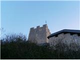
 | Štore - Old Castle of Celje
The Old Castle of Celje is located southeast of Celje on a panoramic hill called Grajski hrib. The castle, abandoned in the 18th century, was the...
1 h 30 min |
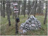
 | Krog - Sveti Kvirik
The church or chapel of St. Kvirik (also listed on maps and elsewhere as St. Kirk, Kirik, Kvirk, Kvirin, or Kirin) stands on a panoramic rise bet...
1 h 15 min |
 | Naraplje - Janški vrh
Janški vrh is a 417-meter-high peak on which stands a small namesake settlement and the Church of St. John the Baptist from the 15th century. The...
1 h 30 min |
 | Phliški bajer - Mengeška koča on Gobavica (ridge path)
Gobavica is a hill rising above Mengeš. Mengeška koča mountain hut stands on it, along with a goat pen. It is one of the starting points for the ...
1 h 10 min |
 | Jablje Castle - Mengeška koča on Gobavica (lower path)
Gobavica is a hill rising above Mengeš. Mengeška koča mountain hut stands on it, along with a goat pen. It is one of the starting points for the ...
1 h 55 min |
 | Lokvica - Renški vrh
Renški vrh is a 449-meter-high hill located in the heart of the Črni hribi ridge. From the summit, which has a summit logbox and a decaying bench...
1 h 55 min |
 | Ljubljana (Gruberjeva brv) - Orle
Orle is a settlement in the Municipality of Škofljica, located on a small hill northeast of the Ljubljana Marshes. A few meters below the highest...
1 h 45 min |
 | Ljubljana (Žabja vas) - Orle
Orle is a settlement in the Municipality of Škofljica, located on a small hill northeast of the Ljubljana Marshes. A few meters below the highest...
1 h 15 min |
 | Stainz bei Straden - Rosenberg
Rosenberg is a panoramic peak located south of the Aussichtswarte Vulkanland observation tower, or just slightly above the settlement of Rožni Vr...
1 h 10 min |
 | Lokvica - Veliki vrh (Črni hribi)
Veliki vrh is a 463-meter-high hill located in the Črni hribi ridge. From the summit, which has a summit logbox, there is no view due to the fore...
1 h 30 min |
 | Dragomer - Strmca (via Debeli hrib)
Strmca is a lesser-known forested hill located between the settlements of Brezje pri Dobrovi and Log pri Brezovici. Due to the forest cover, ther...
1 h 15 min |
 | Stainz bei Straden - Aussichtswarte Vulkanland (via Rosenberg)
The 41-meter-high lookout tower Aussichtswarte Vulkanland (or Aussichtswarte Frutten-Gießelsdorf) is located above the settlement Frutten-Gießels...
1 h 30 min |
| Stainz bei Straden - Aussichtswarte Vulkanland (Um die Mitte)
The 41-meter-high lookout tower Aussichtswarte Vulkanland (or Aussichtswarte Frutten-Gießelsdorf) is located above the settlement Frutten-Gießels...
1 h 30 min |
 | Dragomer (bajer) - Vrhovčev grič (via Ferjanka and Strmca)
Vrhovčev grič is an indistinct, forested peak located just a few meters off the marked trail between Debeli hrib and Strmca....
1 h 10 min |
 | Svečina - Plački vrh
Plački vrh is a peak in Slovenske Gorice. It lies in the municipality of Kungota, right on the border with Austria.A 28-meter-high lookout tower ...
1 h 35 min |
 | Lake Gradišče - Sveti Mohor on Mohorjev hrib (via Vinje pri Moravčah)
The church of St. Mohor is situated on a panoramic rise, the lower peak of Mohorjev hrib above Moravče. From the top, a beautiful view opens up t...
1 h 35 min |
 | Skaručna - Smledniški hrib (Stari grad) (via Zapoški hrib)
Stari grad (also known as Smlednik Castle) is located on a small hill southwest of Valburga. In recent years, the castle has been renovated and n...
1 h 40 min |
 | Repnje - Smledniški hrib (Stari grad)
Stari grad (also known as Smlednik Castle) is located on a small hill southwest of Valburga. In recent years, the castle has been renovated and n...
1 h 15 min |
 | Hunting cottage Muljava - Mali Petrovac (Petrova gora) (via Mali Velebit)
Mali Petrovac is a rather low hill located somewhere on the border between Banija and Kordun, as well as Pannonian Croatia and Gorski Kotar. The ...
1 h 15 min |
 | Rdeči Kal - Ostri vrh (above Globodol) (via Velika raven)
Ostri vrh is a 523-meter-high peak located between Vrbovec, Rdeči Kal, Gorenji, Srednji, and Dolenji Globodol, Dolnji and Gornji Ajdovec, and Pod...
1 h 15 min |
| Dom Frata - Ostri vrh (above Globodol)
Ostri vrh is a 523-meter-high peak located between Vrbovec, Rdeči Kal, Gorenji, Srednji, and Dolenji Globodol, Dolnji and Gornji Ajdovec, and Pod...
1 h 20 min |
 | Liboje - Kamčič (via organic farm Kralj - southern approach)
Kamčič is a wooded peak in the Posavje Hills, located north of Šmohor between Kotečnik to the left and Veliki Slomnik to the right. It is recogni...
1 h 10 min |
 | Jama Pekel (parking lot) - Apno (via Pogorišče)
Apno is a 525-metre-high mountain located on the Ponikovski karst. The summit has some benches, a summit register box, but due to the forest ther...
1 h 25 min |
 | Gorjuša - Sveta Trojica (above Dob) (via Dobovlje)
Sveta Trojica is a village located southeast of Dob pri Domžalah. In the upper part of the village, on a scenic hill, stands the Church of the Ho...
1 h 50 min |
 | Gorica pri Slivnici - Church of St. Helena on Javor
The Church of St. Helena stands on Javor, just off the highest point of the nearby peak where there is also a summit register box and an NOB monu...
1 h 45 min |
 | Zagrad - Vipota (via crossing Ivankovič)
Vipota is a 532-meter-high peak south of Celje above the left bank of the Savinja River. Approaches to the summit are possible from several direc...
1 h 15 min |
 | Zgornje Poljčane - Ljubična gora
Ljubična gora is an elongated hill above the settlements of Ljubično, Zbelovo and Zbelovska gora. The peak is hidden in forest and not well visib...
1 h 15 min |
 | Velika Kostrevnica - Kožljevec
Kožljevec (also Kožlevec) is a 533-meter-high hill above Cerovica in the municipality of Šmartno pri Litiji. The forested summit features a logbo...
1 h 10 min |
 | Brezje pri Dobrovi - Vrh (Debeli hrib) (via Strmca)
Vrh is a 540-meter-high hill on the Debeli hrib ridge, which lies between the Ljubljana Marshes and the Horjulščica river valley. The view from t...
1 h 15 min |
 | Okrog (Lazar) - Zaplaz
Zaplaz is a 543-meter-high hill located above Čatež, a settlement best known as the endpoint of the Levstik Trail (From Litija to Čatež). The sum...
1 h 10 min |
 | Pliskovica - Volnik
Volnik (Monte Lanaro in Italian) is a 546 m high hill located near the village of Pliskovica on the Karst. At the summit there is a small tower, ...
1 h 30 min |
 | Wildon - Buchkogel (Wildoner Berg)
Buchkogel or Wildoner Berg is a 550-meter-high hill in southern Styria. Buchkogel together with the peaks Wildoner Schlossberg (450 m) and Bockbe...
1 h 30 min |
 | Žena Glava - Sveti Duh (Hum)
Sveti Duh is a chapel located northeast of Hum, the highest peak on Vis island, though it is under military control and inaccessible. From the ch...
1 h 45 min |
 | Bad Gleichenberg (Eichgraben Weg) - Bschaidkogel (via Steinriegel)
Bschaidkogel is a 563-meter-high mountain located northeast of the town of Bad Gleichenberg....
1 h 30 min |
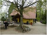
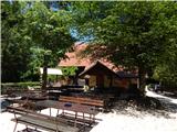
 | Lopata - Planinski dom Šentjungert
The mountain hut is located just a few meters below the summit of Gora, where the Church of St. Kunigunda stands; it was built in the 14th centur...
1 h 30 min |
 | Gorica pri Slivnici - Rifnik
Rifnik is a 568-meter-high peak situated south of Šentjur pri Celju. The summit, known for its archaeological site, offers nice views towards Šen...
1 h 15 min |
 | Treskavac - Obzova
Obzova is the highest point on the island of Krk. Like the entire surrounding area, the summit is completely rocky. Interesting are the pools nea...
1 h 30 min |
 | Šahovec - Trebni vrh (Baragova pot)
Trebni vrh is a 581-meter-high hill located south or southwest of Trebnje. On the forested summit stands a bench, and nearby is a logbook box wit...
1 h 5 min |
| Dobrnič - Trebni vrh (via Šahovec)
Trebni vrh is a 581-meter-high hill located south or southwest of Trebnje. On the forested summit stands a bench, and nearby is a logbook box wit...
1 h 45 min |
 | Ljubljana (Šentvid) - Toško Čelo
Toško Čelo is a 590-metre hill above the village of the same name. From the summit, or slightly below it, a beautiful view opens over part of Lju...
1 h 45 min |
 | Bad Gleichenberg (Eichgraben Weg) - Gleichenberger Kogel (via Mühlsteinbruch)
Gleichenberger Kogel is a 598-meter-high mountain of volcanic origin located above Bad Gleichenberg in Styria....
1 h 10 min |
| Bad Gleichenberg (Eichgraben Weg) - Gleichenberger Kogel
Gleichenberger Kogel is a 598-meter-high mountain of volcanic origin located above Bad Gleichenberg in Styria....
1 h 5 min |
| Bad Gleichenberg (Eichgraben Weg) - Gleichenberger Kogel (via Steinriegel)
Gleichenberger Kogel is a 598-meter-high mountain of volcanic origin located above Bad Gleichenberg in Styria....
1 h 55 min |
 | Polhov Gradec - Visoki hrib
Visoki hrib is a 602-meter-high hill located south of Polhov Gradec. From the summit, which is partly overgrown with forest, a beautiful view ope...
1 h 15 min |
 | Stojdraga (Glažuta) - Tuščak (Žumberačka gora)
Tuščak is a forested hill above the Bregana River valley on Žumberačka gora. The summit features a logbox....
1 h 10 min |
 | Griže - Dragov dom na Homu (direct path)
Dragov dom is located on a scenic hill south of Šempeter. From the summit, where there is also the Church of St. Magdalena, there is a fine panor...
1 h 30 min |
| Griže - Dragov dom na Homu (via Zahom)
Dragov dom is located on a scenic hill south of Šempeter. From the summit, where there is also the Church of St. Magdalena, there is a fine panor...
1 h 50 min |
| Griže - Dragov dom na Homu (via Lajnarjev hrib)
Dragov dom is located on a scenic hill south of Šempeter. From the summit, where there is also the Church of St. Magdalena, there is a fine panor...
1 h 40 min |
| Šešče pri Preboldu - Dragov dom na Homu (Brdovska pot)
Dragov dom is located on a scenic hill south of Šempeter. From the summit, where there is also the Church of St. Magdalena, there is a fine panor...
1 h 15 min |