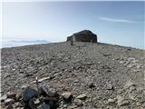
 | Tomčeva koča na Poljški planini - Begunjščica
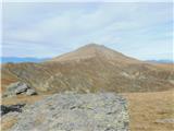
Begunjščica is a mountain range in the Karawanks east of Stol. Its highest peak is Veliki Vrh, which at over 2,000 m offers a fine view across ce...
2 h 50 min |
 | Šport hotel - Mrežce
Mrežce is a panoramic peak near Lipanski vrh, which is visible on the other side of the gully between the two peaks. Since the slopes towards Pok...
2 h 40 min |
 | Rudno polje - Mrežce
Mrežce is a panoramic peak near Lipanski vrh, which is visible on the other side of the gully between the two peaks. Since the slopes towards Pok...
2 h 40 min |
 | Rudno polje - Lipanski vrh
The panoramic Lipanski vrh is located above the Blejska koča on the Lipanca mountain pasture. From the summit, which drops steeply towards the Kr...
2 h 55 min |
 | Strmec - Debela peč (via Spodnja Brda)
Debela peč is a 2014 m high mountain that rises steeply above the Krma valley on one side and gently descends towards the expansive Pokljuka fore...
2 h 45 min |
 | Šport hotel - Debela peč
Debela peč is a 2014 m high mountain that rises steeply above the Krma valley on one side and gently descends towards the expansive Pokljuka fore...
3 h 30 min |
 | Rudno polje - Debela peč
Debela peč is a 2014 m high mountain that rises steeply above the Krma valley on one side and gently descends towards the expansive Pokljuka fore...
3 h 15 min |
 | Vrh Bače - Črna prst
On the northern slope of the summit ridge of Črna prst, black soil is visible the feature after which the mountain is named. Črna prst is renown...
3 h 10 min |
 | Bukovnik - Velika Raduha (via Durce)
Velika Raduha, at 2062 m, is the highest peak of the Raduha range, which rises steeply east of Robanov Kot. From the summit, with its registratio...
2 h 50 min |
 | Planina Vodol - Velika Raduha
Velika Raduha, at 2062 m, is the highest peak of the Raduha range, which rises steeply east of Robanov Kot. From the summit, with its registratio...
2 h 40 min |
 | End of road on Vogar - Mala Tičarica (via Štapce)
Mala Tičarica is a highly panoramic mountain above the Twin Triglav Lakes. From the summit there is a beautiful view toward the Koča pri Triglavs...
3 h 30 min |
 | Šport hotel - Brda (east path)
Brda is a panoramic peak situated between Pokljuka and Krma. The summit has a stamp attached to a metal pole and offers a beautiful view towards ...
3 h 15 min |
 | Rudno polje - Brda (east path)
Brda is a panoramic peak situated between Pokljuka and Krma. The summit has a stamp attached to a metal pole and offers a beautiful view towards ...
3 h 10 min |
 | Rudno polje - Brda (west path)
Brda is a panoramic peak situated between Pokljuka and Krma. The summit has a stamp attached to a metal pole and offers a beautiful view towards ...
2 h 55 min |
 | Erjavčev rovt - Frauenkogel/Dovška Baba (via Brvog)
Dovška Baba is a 1891-meter-high peak located on the border ridge between Slovenia and Austria. From the summit, which has a registration box and...
2 h 45 min |
 | Ljubelj - Srednji vrh (above Završnica) (via source of Završnica)
Srednji vrh is a panoramic mountain covered in dwarf pine, located between Stol, Vrtača and Begunjščica. From the summit, which drops steeply to ...
2 h 40 min |
 | Ljubelj - Srednji vrh (above Završnica) (on the slope of Vrtača)
Srednji vrh is a panoramic mountain covered in dwarf pine, located between Stol, Vrtača and Begunjščica. From the summit, which drops steeply to ...
3 h |
 | Ljubelj - Srednji vrh (above Završnica) (on a slope of Vrtača)
Srednji vrh is a panoramic mountain covered in dwarf pine, located between Stol, Vrtača and Begunjščica. From the summit, which drops steeply to ...
2 h 40 min |
 | Javorje - Rodica (marked way)
The mountain Rodica is located above Bohinj in the Lower Bohinj Mountains. From the summit there is a beautiful view over the Julian Alps and the...
2 h 45 min |
 | Ski hotel Vogel - Rodica
The mountain Rodica is located above Bohinj in the Lower Bohinj Mountains. From the summit there is a beautiful view over the Julian Alps and the...
3 h |
 | Dom na Gospincu - Kalški greben (via Dolga Njiva)
Kalški greben is a 2224 m high peak and the highest point of the ridge bearing the same name. From the summit, where there is a summit register a...
3 h 20 min |
 | Kriška planina - Mokrica (via Kompotela)
Mokrica is a panoramic peak east of Kompotela. The summit, partially covered with dwarf pines, has a summit logbook....
2 h 45 min |
| Planina Jezerca - Mokrica (via Kompotela)
Mokrica is a panoramic peak east of Kompotela. The summit, partially covered with dwarf pines, has a summit logbook....
3 h |
 | Rudno polje - Debeli vrh above Lipanca (via Kačji rob)
Debeli vrh is a 1962 m high mountain located in the ridge that rises steeply above the Krma valley. From the summit, where a stamp is attached to...
2 h 45 min |
 | Šport hotel - Debeli vrh above Lipanca
Debeli vrh is a 1962 m high mountain located in the ridge that rises steeply above the Krma valley. From the summit, where a stamp is attached to...
3 h 15 min |
| Rudno polje - Debeli vrh above Lipanca (via Blejska koča)
Debeli vrh is a 1962 m high mountain located in the ridge that rises steeply above the Krma valley. From the summit, where a stamp is attached to...
2 h 45 min |
 | Planina Kuk - Vogel (direct way)
Many associate the name Vogel first with the Vogel ski resort near the eponymous peak. From the north, it is recognizable by its pyramidal shape,...
2 h 45 min |
| Planina Kuk - Vogel (via Globoko)
Many associate the name Vogel first with the Vogel ski resort near the eponymous peak. From the north, it is recognizable by its pyramidal shape,...
3 h 30 min |
 | Koutschitz Alm/Kočiška planina - Poludnig/Poludnik
Poludnik/Poludnig is located on the eastern part of the Carnic Alps. Because there is no higher peak nearby, there is a very nice view from Polud...
3 h |
 | Waldheimhütte - Zirbitzkogel (via Wildsee)
Zirbitzkogel, at 2,396 m, is the highest peak of the Labotniške Alpe / Seetaler Alpen. From the summit, where a cross and a panorama board stand,...
3 h 32 min |
| Waldheimhütte - Zirbitzkogel (via Rothaidenhütte)
Zirbitzkogel, at 2,396 m, is the highest peak of the Labotniške Alpe / Seetaler Alpen. From the summit, where a cross and a panorama board stand,...
3 h 7 min |
| Waldheimhütte - Zirbitzkogel (via Lavantsee)
Zirbitzkogel, at 2,396 m, is the highest peak of the Labotniške Alpe / Seetaler Alpen. From the summit, where a cross and a panorama board stand,...
2 h 47 min |
 | Waldheimhütte - Fuchskogel (via Wildsee)
Fuchskogel is a peak south of Zirbitzkogel in the Seetaler Alpen mountain group. The summit is broad and mostly covered in grass. More precisely,...
2 h 45 min |
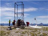
 | Waldheimhütte - Scharfes Eck (Direct way)
Scharfes Eck is a peak on which stands an Austrian meteorological radar station. From the summit, there is a beautiful view of the neighbouring p...
2 h 45 min |
| Tonnerhütte - Scharfes Eck
Scharfes Eck is a peak on which stands an Austrian meteorological radar station. From the summit, there is a beautiful view of the neighbouring p...
3 h |
 | Salzstiegelhaus - Großenberg (Packalpe) (via Ameringkogel)
Großenberg, also known as Größing, is the northernmost two-thousander in the Packalpe mountain group. From its expansive grassy summit, where a t...
3 h |
| Salzstiegelhaus - Großenberg (Packalpe)
Großenberg, also known as Größing, is the northernmost two-thousander in the Packalpe mountain group. From its expansive grassy summit, where a t...
2 h 55 min |
 | Nassfeld - Monte Cavallo / Rosskofel (via Sella di Aip / Rudnig sattel)
Konjski Špik / Monte Cavallo di Pontebba / Rosskofel is a 2,240-meter-high and highly panoramic mountain in the main ridge of the Carnic Alps in ...
4 h |
 | Spodnje Sleme - Govca (Olševa)
Govca is the highest peak of the Olševa range, rising above Koprivna, Solčava, and Remšenik (Remšenik/Remschenig is a valley on the Austrian side...
3 h |
 | Pod Peco / Koprein-Petzen - Govca (Olševa) (via Kumer)
Govca is the highest peak of the Olševa range, rising above Koprivna, Solčava, and Remšenik (Remšenik/Remschenig is a valley on the Austrian side...
4 h 30 min |
| Mountain hut on farm Kumer - Govca (Olševa)
Govca is the highest peak of the Olševa range, rising above Koprivna, Solčava, and Remšenik (Remšenik/Remschenig is a valley on the Austrian side...
3 h 45 min |
 | Windische Hohe - Kobesnock
Kobesnock is a lesser-known peak west of the massive Dobrač range. From its summit, which features a cross, there are fine views of Dobrač, the l...
2 h 45 min |
 | Ladinger Straße - Großer Sauofen (Saualpe) (via Offnerhütte)
Großer Sauofen is, due to its location and shorter precipitous southwestern wall, one of the more prominent peaks on the Svinja / Saualpe mountai...
2 h 40 min |
 | Ladinger Straße - Ladinger Spitz (Saualpe) (via Ladinger Hütte)
Velika Svinja, known in German as Ladinger Spitz, is at 2079 m the highest peak of the Svinja / Saualpe mountain range. From the summit, which ha...
3 h |
 | Ladinger Straße - Ladinger Spitz (Saualpe) (via Wolfsberger Hütte)
Velika Svinja, known in German as Ladinger Spitz, is at 2079 m the highest peak of the Svinja / Saualpe mountain range. From the summit, which ha...
2 h 50 min |
 | Klippitztörl - Ladinger Spitz (Saualpe) (via Geierkogel and Gertrusk)
Velika Svinja, known in German as Ladinger Spitz, is at 2079 m the highest peak of the Svinja / Saualpe mountain range. From the summit, which ha...
4 h 10 min |
| Klippitztörl - Ladinger Spitz (Saualpe)
Velika Svinja, known in German as Ladinger Spitz, is at 2079 m the highest peak of the Svinja / Saualpe mountain range. From the summit, which ha...
3 h 35 min |
 | Rudno polje - Okroglež
Okroglež is a peak covered with dwarf pines, located between Debela peč and Brda. From the summit, which has a stamp (no logbook), a nice view op...
2 h 55 min |
 | Koprivna (Kumer) - Wackendorfer Spitze
Veška kopa, also known as Veški vrh or by its German name Wackendorfer Spitze, is the northernmost two-thousander in the Peca range. From its ind...
2 h 55 min |
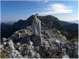
 | Jakobe - Feistritzer Spitze (easy path)
Bistriška špica is a 2113 m high peak located on the Austrian side of Peca. From the summit, which features a cross, there is a fine view of the ...
3 h 45 min |
| Koprivna (Kumer) - Feistritzer Spitze (Austrian path)
Bistriška špica is a 2113 m high peak located on the Austrian side of Peca. From the summit, which features a cross, there is a fine view of the ...
2 h 55 min |
 | Pod Peco/Koprein-Petzen - Končnikov vrh (Peca) (slovenska pot)
Končnikov vrh (German: Knieps) is a 2109 m high peak situated in the central part of Peca. From the grassy summit, there is a beautiful view of t...
3 h 15 min |
| Koprivna (Kumer) - Končnikov vrh (Peca) (slovenska pot)
Končnikov vrh (German: Knieps) is a 2109 m high peak situated in the central part of Peca. From the grassy summit, there is a beautiful view of t...
2 h 55 min |
 | Jakobe - Končnikov vrh (Peca) (easy path)
Končnikov vrh (German: Knieps) is a 2109 m high peak situated in the central part of Peca. From the grassy summit, there is a beautiful view of t...
2 h 45 min |
 | Plockenpass - Creta di Collinetta / Cellon
Creta di Collinetta / Cellon is a 2,238-meter-high mountain located west of the Plöcken Pass. From the summit, which features a cross, there is a...
3 h |
 | Planina Ravne - Mala Ojstrica (via Dolga trata)
Mala Ojstrica is an indistinct peak located between Ojstrica, Molička Planina mountain pasture, and Korošica. From the summit, which features a l...
3 h 45 min |
 | Heidi Alm - Mallnock (via Klomnock)
Mallnock is a 2226 m high peak located north of the settlement St. Oswald in the Krške Alpe. From the summit, where a cross stands, a beautiful v...
2 h 45 min |
 | Passo Staulanza - Monte Pena
Monte Pena is a 2,196-meter-high mountain in the Pelmo group. From its summit, topped by a cross, there are superb views of nearby Monte Pelmo an...
3 h 30 min |
 | Klippitztörl - Kienberg (Saualpe) (via Geierkogel)
Kienberg is a 2,050-meter-high peak in the massif of Svinška planina / Saualpe. From the grassy summit, a beautiful view opens up over a larger p...
2 h 50 min |
 | Klippitztörl - Gertrusk (Saualpe) (via Geierkogel)
Gertrusk is a panoramic two-thousander in the central part of the Saualpe. A cross stands on the summit, next to it a summit register box with a ...
3 h 35 min |
| Klippitztörl - Gertrusk (Saualpe)
Gertrusk is a panoramic two-thousander in the central part of the Saualpe. A cross stands on the summit, next to it a summit register box with a ...
3 h 5 min |
 | Passo San Pellegrino - Col Margherita
Col Margherita is a 2,514-meter-high mountain rising above the San Pellegrino Pass in the Dolomites. Several cableways lead to it, and in the sum...
3 h |
| Vitlenica - Veliki Vilinac (Vitlenica - Vilinac)
Veliki Vilinac is one of the peaks of the Čvrsnica mountain range, located west of Jablanica in Blidinje Nature Park. Čvrsnica is bounded by the ...
3 h |
 | Sella di Razzo - Clapsavon (via 210)
Clapsavon is a 2,462-meter-high mountain in the Carnic Alps in Italy. It lies about an hour's walk west of the 2,474-meter-high Bivera. Both peak...
3 h |
 | Lakkos tou Mygerou - Agathias (Kreta)
Agathias is the fourth-highest mountain on the island of Crete in Greece, at 2,424 meters. Agathias (Gr. Αγκαθιάς) is located southeast of Timios...
3 h |
 | Lakkos tou Mygerou - Timios Stavros / Psiloritis (Kreta)
Timios Stavros is Crete's highest mountain at 2,456 meters and also the highest among the Greek islands. Due to its topographic prominence, it is...
3 h |
 | Pass Lius above Ligosullo - Tersadia (from Ligosullo)
Tersadia is a mountain in the heart of the Carnic Alps, just far enough from its higher neighbors to serve as an excellent vantage point, especia...
3 h |
 | parking below Weinebene - Krakaberg (Golica / Koralpe) (panoramic path)
Krakaberg is a 2,070-meter-high peak located south of Großer Speikkogel, the highest peak of Golica / Koralpe. From the summit, a nice view opens...
3 h 10 min |
 | parking below Weinebene - Steinschneider (via Großes Kar)
Steinschneider is a 2070-meter-high peak in the Golica / Koralpe mountain range, situated northwest of Großer Speikkogel, the highest peak of the...
3 h 15 min |
| Weinebene - Steinschneider (above Pomswasserfall)
Steinschneider is a 2070-meter-high peak in the Golica / Koralpe mountain range, situated northwest of Großer Speikkogel, the highest peak of the...
3 h 20 min |
| parking below Weinebene - Steinschneider (above Pomswasserfall)
Steinschneider is a 2070-meter-high peak in the Golica / Koralpe mountain range, situated northwest of Großer Speikkogel, the highest peak of the...
3 h 20 min |
 | Oberfresen (Brendlwald) - Bürgerhalt (Koralpe)
Bürgerhalt is a lesser-known peak in the Golica / Koralpe mountain range, situated between the peaks Krennkogel and Großer Frauenkogel....
3 h 15 min |
 | Raxalm-Berggasthof (Rax) - Heukuppe (Rax) (via Raxgmoahütte)
Heukuppe is a 2007-meter-high peak in the Northern Limestone Alps and the highest peak of the Rax mountain group. A large monument stands on the ...
3 h 50 min |
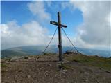
 | Preiner Gscheid - Preiner Wand (Rax) (Göbl-Kühn-Steig)
Preiner Wand is a panoramic peak in the Rax mountain group, where a large cross stands....
2 h 40 min |
 | Preiner Gscheid - Jakobskogel (Rax) (Göbl-Kühn-Steig)
Jakobskogel is a 1,737-meter-high peak in the Rax mountain group, located above the Ottohaus hut. From the summit, where a cross stands, beautifu...
3 h 40 min |
 | Preiner Gscheid - Raxgmoahütte (Rax) (via Karl-Ludwig-Haus, Schlangenweg)
Raxgmoahütte is a hut owned by the Austrian mountain rescue service, open year-round as a bivouac or shelter. From the hut on top of a panoramic ...
3 h 5 min |
 | Koprein-Petzen - Križnik (Peca)
Križnik is a 2,109-meter-high peak on Peca, located on the Austrian side of the mountain. From the summit, just a short way above the marked path...
3 h |