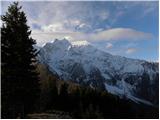
 | Gozd - Tolsti vrh (Sheep Trail across Kriška Gora)
Tolsti vrh, located west of Storžič, is at 1715 metres also the highest peak of the Kriška gora range, which rises steeply above central Gorenjsk...
2 h 30 min |
 | Tominčev slap Waterfall - Dobrča
Dobrča is a 1634-metre mountain located between Begunje and Tržič. From the summit, which has a registration box with a stamp, the view opens onl...
3 h |
 | Grahovše - Veliki Javornik (Ženiklovec)
Veliki Javornik (also known as Ženiklovec) is a 1716 m high peak located between Storžič and Stegovnik. From the grassy summit with its registrat...
2 h 45 min |
 | Tržiški graben - Veliki Javornik (Ženiklovec)
Veliki Javornik (also known as Ženiklovec) is a 1716 m high peak located between Storžič and Stegovnik. From the grassy summit with its registrat...
2 h 30 min |
| Grahovše - Veliki Javornik (Ženiklovec) (via Rekar)
Veliki Javornik (also known as Ženiklovec) is a 1716 m high peak located between Storžič and Stegovnik. From the grassy summit with its registrat...
2 h 45 min |
 | Smrečje - Pečovnik (survey point 1668) (by road)
Pečovnik (1668 m) is a 1668-meter-high mountain located between Plešivec (1801 m) and Virnikov Grintovec (1654 m). From its grassy summit on the ...
2 h 45 min |
 | Rateče - Ofen/Peč (western path, past bivouac and on footpath)
Peč (also known as Tromeja; in Italian Monte Forno, in German Dreiländereck or Ofen) is a 1508 m high peak located at the tripoint between Sloven...
2 h 15 min |
| Rateče - Ofen/Peč (western path, past bivouac and on mule track)
Peč (also known as Tromeja; in Italian Monte Forno, in German Dreiländereck or Ofen) is a 1508 m high peak located at the tripoint between Sloven...
2 h 20 min |
 | Polja - Ofen/Peč (via Petelinjek)
Peč (also known as Tromeja; in Italian Monte Forno, in German Dreiländereck or Ofen) is a 1508 m high peak located at the tripoint between Sloven...
2 h 45 min |
| Polja - Ofen/Peč (via Kališje)
Peč (also known as Tromeja; in Italian Monte Forno, in German Dreiländereck or Ofen) is a 1508 m high peak located at the tripoint between Sloven...
2 h 15 min |
 | Klemenčevo - Kamniški vrh (by Korošaki waterfalls)
Kamniški vrh is a 1259-metre-high mountain located north of Kamnik, more precisely between Stahovica and the Korošica valley. From the summit, wh...
2 h 15 min |
 | Planina pod Golico - Klek (via Rožca)
Klek is a 1753-metre-high mountain located between Hruški vrh and the better-known Golica. The summit, on the border between Slovenia and Austria...
2 h 20 min |
 | Planina pod Golico - Klek (via Ovčarska koča)
Klek is a 1753-metre-high mountain located between Hruški vrh and the better-known Golica. The summit, on the border between Slovenia and Austria...
3 h |
 | Srednji Vrh - Vošca (via Zajčnik)
Vošca is a 1737 m high peak located west of Trupejevo poldne. From the grassy summit, there is a beautiful view of the Julian Alps, western Karaw...
2 h 35 min |
 | Srnjak - Vošca
Vošca is a 1737 m high peak located west of Trupejevo poldne. From the grassy summit, there is a beautiful view of the Julian Alps, western Karaw...
2 h 45 min |
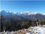
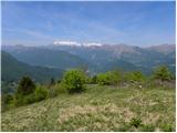
177100.th.jpg) | Gate (Belca) - Mojstrovica
Mojstrovica is a panoramic grassy peak in the western part of the Karawanks, located between the Belca Valley and the Hladnik stream valley. From...
2 h 20 min |
 | Planina Spodnji Kozjek - Jerebikovec
The panoramic, slightly overgrown peak is located above Mojstrana and Radovna. From the summit, there is a beautiful view towards the Karawanks a...
2 h 30 min |
 | Okrog pri Motniku - Vivodnik (via Biba planina)
Vivodnik, at 1508 meters, is the highest peak of Menina planina, a plateau rising south of Gornji Grad. From the summit, which has a small observ...
2 h 25 min |
| Okrog pri Motniku - Vivodnik (via Oseke and peak Drč)
Vivodnik, at 1508 meters, is the highest peak of Menina planina, a plateau rising south of Gornji Grad. From the summit, which has a small observ...
2 h 15 min |
| Češnjice v Tuhinju - Vivodnik
Vivodnik, at 1508 meters, is the highest peak of Menina planina, a plateau rising south of Gornji Grad. From the summit, which has a small observ...
2 h 25 min |
 | Srednji vrh - Mallestiger Mittagskogel (Via Grajšca)
Ostra peč, known in German as Mallestiger Mittagskogel, is an 1801 m high mountain located on the northern side of the main Karawanks ridge. From...
3 h 10 min |
 | Source of Ljubija - Smrekovec (via Leskovškova pustota)
Smrekovec is a mountain of volcanic origin on the eastern edge of the Smrekovec mountain range. The wide grassy summit features a pyramid with a ...
2 h 20 min |
 | Valley of stream Žep - Komen
At 1684 meters, Komen is the highest peak in the Smrekovec mountain range, which borders between Styria and Carinthia. In good weather, the summi...
2 h 30 min |
 | Valley of stream Žep - Veliki Travnik (Turnovka) (via partisan hospital)
Veliki Travnik, also known as Turnovka by the locals, is located on the western edge of the Smrekovec mountain range. From the summit, which has ...
2 h 25 min |
 | Smrečje - Pečovnik (by road)
Pečovnik is a 1640-meter-high peak situated in the ridge of mountains between Košuta and Virnikov Grintovec. From the partly vegetated peak, a ni...
2 h 35 min |
 | Nemci - Mrzovec
Mržovec is the most prominent peak in the heart of the Trnovo Plateau. Its location offers wonderful views, though high trees obscure them from t...
2 h 40 min |
 | Jevšček - Monte Mataiur/Matajur
Matajur is a panoramic mountain located on the border between Slovenia and Italy. From the summit there is a beautiful view of Kobariški or Bregi...
2 h 30 min |
 | Poljšica pri Gorjah (Zatrata) - Galetovec (on footpath)
Galetovec is an indistinct peak on the southeastern part of the Pokljuka plateau. From the summit, which has a logbook, there is a nice view of t...
2 h 35 min |
 | NC Planica - Glave (by ski jumping hill)
Glave is an indistinct side ridge of Ponca, rising steeply west of Planica. Maps incorrectly label its highest peak (1,760 m) as Ovčja stran; tha...
2 h 30 min |
| Rateče (Ledine) - Glave
Glave is an indistinct side ridge of Ponca, rising steeply west of Planica. Maps incorrectly label its highest peak (1,760 m) as Ovčja stran; tha...
2 h 50 min |
 | Podbreg - Logarska peč
Logarska peč is a peak or viewpoint a few meters below the summit, rising steeply above the Logarska Valley. From Logarska peč there is a very ni...
2 h 20 min |
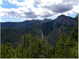
 | Bukovo - Kojca (north path)
Kojca is a panoramic peak rising south of Baška grapa. From the summit, where there is a haystack, fine views extend over the Lower Bohinj Mounta...
2 h 15 min |
 | Bukovo - Kojca (south path)
Kojca is a panoramic peak rising south of Baška grapa. From the summit, where there is a haystack, fine views extend over the Lower Bohinj Mounta...
2 h 15 min |
 | Zalog - Grebenc
Grebenc is a lesser-known peak that rises steeply above Mala and Velika Poljana. From this little-visited summit, on a clear day there is a nice ...
2 h 25 min |
 | Spodnje Danje - Altemaver (Ratitovec)
Altemaver (Ratitovec), at 1,678 meters, is the highest peak of Ratitovec. From its grassy summit, there is a beautiful view of the Julian Alps, J...
2 h 30 min |
 | Srednji Vrh - Zajčnik
Zajčnik (also Blekova) is a 1746-meter-high peak situated northeast of Vošca. From the partly vegetated summit, which borders Slovenia and Austri...
2 h 10 min |
 | Makekova Kočna - Visoki vrh above Jezersko (via Javornik)
Visoki vrh is a 1459-meter-high mountain in the ridge between Makekovo Kočna and Ravenska Kočna. From the summit, there is a fine view toward Koč...
2 h 15 min |
 | Solarji - Kuk (Kolovrat)
Kuk is the highest peak of the Kolovrat range at 1243 m. The range extends from Livek to Kambreško. From the summit, which has several transmitte...
2 h 10 min |
 | Spodnje Danje - Kremant (Ratitovec)
Kremant is a 1,654 m high peak located on the western part of Ratitovec. From the summit, where a stamp is attached to a metal pole, a nice view ...
2 h 30 min |
 | Kosmačev preval - Lengarjeva glava
Lengarjeva glava is a 1,498 m high peak situated between the Vrata and Kot valleys. From the partly vegetated summit, a nice view opens up on Deb...
3 h 30 min |
 | Srnjak - Tamarča
Tamarča is a lesser-known peak located northwest of Vošca. From its summit, surrounded by larch forest, a nice view opens up onto the Martuljek m...
2 h 30 min |
 | Vodel - Hunting cottage Na Glinu
The hunting cottage Na Glinu is situated on a panoramic hill between the mountain pastures Suha and Poljana. From the cottage there opens a nice ...
2 h 35 min |
 | Javorje - Gradovec (path over Glin)
Gradovec is a 1,692-meter-high peak located north of the ridge of Spodnje Bohinjske gore, specifically above the mountain pasture Poljana. From t...
3 h 10 min |
 | Trbiž / Tarviso - Florjanka / Monte Florianca (on transport road)
Florjanka is a 1,653-meter-high mountain on the Italian side of the Julian Alps. At or just below the summit is a reservoir for snowmaking on the...
2 h 30 min |
 | Concentration camp - Hajnžev Praprotnik / Zeller Prapotnik
Hajnžev Praprotnik is a 1,727-metre peak on the Austrian side of the Karawanks, more precisely between Košutica and the settlement of Sele-Zvrhnj...
3 h 15 min |
| Vranček - Hajnžev Praprotnik / Zeller Prapotnik
Hajnžev Praprotnik is a 1,727-metre peak on the Austrian side of the Karawanks, more precisely between Košutica and the settlement of Sele-Zvrhnj...
3 h 20 min |
 | Slovenji Plajberk / Windisch Bleiberg - Kosmatica / Kosmatitza
Kosmatica / Kosmatitza is a 1,659-meter-high peak entirely on the Austrian side of the Karawanks, north of Vrtača. From the summit, which is part...
3 h |
 | Slovenji Plajberk / Windisch Bleiberg - Veliki Rob / Großer Rain
Veliki Rob / Großer Rain is a 1,464-meter-high peak located on the Austrian side of the Karawanks, specifically in the ridge above the Poden / Bo...
2 h 10 min |
| Slovenji Plajberk / Windisch Bleiberg - Veliki Rob / Großer Rain (via Veronjak / Hausberg)
Veliki Rob / Großer Rain is a 1,464-meter-high peak located on the Austrian side of the Karawanks, specifically in the ridge above the Poden / Bo...
2 h 15 min |
 | Podljubelj - Robič (via Zavetišče na Kalu)
Robič is a 1,384-meter-high peak located between the Tržiška Bistrica Valley and the Košuta ridge. From the summit, there is a beautiful view mai...
2 h 15 min |
| Podljubelj (Pod Košuto) - Robič (via lake Jezero pri Čežov)
Robič is a 1,384-meter-high peak located between the Tržiška Bistrica Valley and the Košuta ridge. From the summit, there is a beautiful view mai...
2 h 15 min |
 | Dovje - Bela peč (above Dovje) (via Blažčeva skala)
Bela peč is a lesser-known peak located above the marked trail from Dovje to Dovška Baba. From the summit, there is a beautiful view to the south...
2 h 15 min |
 | Veliko Tinje - Veliki vrh (on Pohorje) (via Sveti Urh)
Veliki vrh is a 1344-meter-high peak located above the RTC Jakec - Trije kralji ski slope. The highest point of the peak is in the forest, but ju...
2 h 55 min |
 | St. Vinzenz (St. Vinzenz) - Kleinalpl
Kleinalpl is a panoramic expansive grassy peak in the Golica/Koralpe range from which beautiful views extend far to the west....
3 h 35 min |